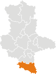
Burgenlandkreis
| Burgenlandkreis | ||
|---|---|---|
| District | ||
| ||
 | ||
| Country |
| |
| State | Saxony-Anhalt | |
| Capital | Naumburg | |
| Area | ||
| • Total | 1,413.4 km2 (545.7 sq mi) | |
| Population (31 December 2017)[1] | ||
| • Total | 181,968 | |
| • Density | 130/km2 (330/sq mi) | |
| Time zone | UTC+01:00 (CET) | |
| • Summer (DST) | UTC+02:00 (CEST) | |
| Vehicle registration | BLK, HHM, NEB, NMB, WSF, ZZ | |
| Website | www.burgenlandkreis.de | |
Burgenlandkreis is a district in Saxony-Anhalt, Germany.
History
The district was established as Landkreis Burgenland by the merger of the former Burgenlandkreis and Landkreis Weißenfels as part of the reform of 2007. On 16 July 2007, the district parliament decided to change the name to Burgenlandkreis, coming into effect on 1 August 2007.[2]
In 2015 the skeletal remains of an ancient inhabitant of Karsdorf dated from the Early Neolithic (7200 BP) were analyzed; he turned out to belong to the paternal T1a-M70 lineage and maternal lineage H1.[3][4]
Towns and municipalities
The Burgenlandkreis consists of the following subdivisions:[5][6]
| Free towns | Free municipalities |
|---|---|
Verbandsgemeinden
1 seat of the Verbandsgemeinde; 2 town
References
- ↑ "Bevölkerung der Gemeinden – Stand: 31. Dezember 2017" (PDF). Statistisches Landesamt Sachsen-Anhalt (in German).
- ↑ Namechange announcement
- ↑ Our Far Forebears (Y-DNA haplogroups )
- ↑ Haak, Wolfgang; Lazaridis, Iosif; Patterson, Nick; Rohland, Nadin; Mallick, Swapan; Llamas, Bastien; Brandt, Guido; Nordenfelt, Susanne; Harney, Eadaoin; Stewardson, Kristin; Fu, Qiaomei; Mittnik, Alissa; Bánffy, Eszter; Economou, Christos; Francken, Michael; Friederich, Susanne; Rafael Garrido Pena; Hallgren, Fredrik; Khartanovich, Valery; Khokhlov, Aleksandr; Kunst, Michael; Kuznetsov, Pavel; Meller, Harald; Mochalov, Oleg; Moiseyev, Vayacheslav; Nicklisch, Nicole; Pichler, Sandra L; Risch, Roberto; Rojo Guerra, Manuel A; et al. (2015). "Massive migration from the steppe is a source for Indo-European languages in Europe". Nature. 522 (7555): 207–211. arXiv:1502.02783. Bibcode:2015Natur.522..207H. doi:10.1038/nature14317. PMC 5048219. PMID 25731166.
- ↑ "Gebietsinformationen". Statistisches Landesamt Sachsen-Anhalt (in German). 7 June 2010. Retrieved 22 August 2010.
- ↑ "Aktuelle Bekanntmachungen der Gemeinde Meineweh". Verbandsgemeinde Wethautal (in German). 20 May 2011. Retrieved 2 August 2011.
External links
- Official website of Burgenlandkreis (in German)

| Urban districts | |
|---|---|
| Rural districts | |
| Former districts | |
Coordinates: 51°9′N 11°52′E / 51.150°N 11.867°E
| Authority control |
|---|
This article is issued from
Wikipedia.
The text is licensed under Creative Commons - Attribution - Sharealike.
Additional terms may apply for the media files.