Burbank, South Dakota
| Burbank, South Dakota | |
|---|---|
| Unincorporated community | |
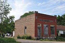 The old Bank of Burbank building | |
 Burbank Location within the state of South Dakota  Burbank Burbank (the US) | |
| Coordinates: 42°44′43″N 96°49′44″W / 42.74528°N 96.82889°WCoordinates: 42°44′43″N 96°49′44″W / 42.74528°N 96.82889°W | |
| Country | United States |
| State | South Dakota |
| County | Clay |
| Time zone | UTC-6 (Central (CST)) |
| • Summer (DST) | UTC-5 (CDT) |
| ZIP codes | 57010 |
Burbank is an unincorporated community in Clay County, South Dakota, United States.[1] Although not recognized by the United States Census Bureau, Burbank has been assigned the ZIP Code 57010.
Burbank was laid out in 1873, and named in honor of John A. Burbank, fourth Governor of Dakota Territory.[2]
References
- ↑ U.S. Geological Survey Geographic Names Information System: Burbank, South Dakota
- ↑ Federal Writers' Project (1940). South Dakota place-names, v.1-3. University of South Dakota. p. 29.
Municipalities and communities of Clay County, South Dakota, United States | ||
|---|---|---|
| Cities | 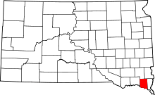 | |
| Town | ||
| Unincorporated communities |
| |
| Footnotes | ‡This populated place also has portions in an adjacent county or counties | |
This article is issued from
Wikipedia.
The text is licensed under Creative Commons - Attribution - Sharealike.
Additional terms may apply for the media files.