Bunch, Oklahoma
| Bunch | |
|---|---|
| Unincorporated community | |
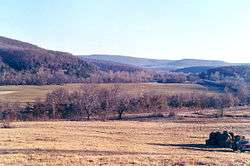 Picture of Bunch almost hidden in the trees from about 1 mile north. There is a Kansas City Southern freight-train just across the road | |
 Bunch Location within the state of Oklahoma  Bunch Bunch (the US) | |
| Coordinates: 35°40′57″N 94°45′38″W / 35.68250°N 94.76056°WCoordinates: 35°40′57″N 94°45′38″W / 35.68250°N 94.76056°W | |
| Country | United States |
| State | Oklahoma |
| County | Adair |
| Elevation | 781 ft (238 m) |
| Time zone | UTC-6 (Central (CST)) |
| • Summer (DST) | UTC-5 (CDT) |
| ZIP codes | 74931 |
| GNIS feature ID | 1100245[1] |
Bunch is an unincorporated community in southwestern Adair County, Oklahoma, United States.[1] It was named after a Cherokee vice-chief named Rabbit Bunch who lived in the area in the 1880s. Nestled in the Sallisaw Creek valley, Bunch is bisected by the Kansas City Southern Railroad, which was built in the 1890s. Bunch is in the Cookson Hills area of eastern Oklahoma which are a part of the western area of the Ozark Mountains. The Cookson Hills Wildlife Management Area is west of the town.[2] The post office's zip code is 74931. Two and one-half miles north of town is Cave Springs Public Schools, a K-12 school which serves Bunch and the surrounding area.
Popular culture
Bunch is one of the prominent locales referenced in Elmore Leonard's crime novel "The Hot Kid", which takes place in the 1930s.
References
- 1 2 "Bunch". Geographic Names Information System. United States Geological Survey.
- ↑ Adair County, Oklahoma General Highway Map (PDF) (Map). Oklahoma Department of Transportation. 1992. Retrieved 2011-10-16.
Municipalities and communities of Adair County, Oklahoma, United States | ||
|---|---|---|
| City | 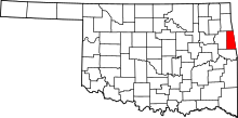 | |
| Towns | ||
| CDPs | ||
| Other unincorporated communities | ||