Bukit Payong
| Bukit Payong | ||
|---|---|---|
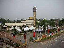 Bukit Payong Mosque, a landmark at the centre of Bukit Payong | ||
| ||
 Bukit Payong Location in Malaysia | ||
| Coordinates: 4°15′N 103°25′E / 4.250°N 103.417°E | ||
| Country |
| |
| State | Terengganu | |
| District | Marang | |
| Population (2010) | ||
| • Total | 26,790 | |
| • Ethnicities |
95.8% Malays 4% Chinese 0.15 others | |
| Time zone | UTC+8 (Malaysian Standard Time) | |
| Postcode | 21xxx | |

Bukit Payong (est. pop. 2010 census: 26790)[1] is a town in the Marang district of Terengganu, on the east coast of peninsular Malaysia.
The population comprises 95.85% Malays, 4% Chinese and 0.15% of other races. The town borders with the district of Kuala Terengganu. It houses several government departments such as Jabatan Pertanian, Jabatan Haiwan, Peladang, and Pejabat Pos. There are two shopping centres; Pasaraya Seri Intan and Kedai Wahab. There are also a lot of bundle shops in the town as well as facilities such as banks, a futsal hall, police station, civic hall, clinics, health centres and schools. The East Coast Expressway interchange also exits here. It is also the seat of the state constituency of the same name. Currently, the seat is held by Pan-Malaysian Islamic Party or PAS after 2013 Malaysia General Election[2]
Gallery
.jpg)
References
| Wikimedia Commons has media related to Bukit Payong. |
- ↑ "Archived copy" (PDF). Archived from the original (PDF) on 2012-11-14. Retrieved 2012-07-12.
- ↑ 1
Coordinates: 5°14′1.25″N 103°06′2.05″E / 5.2336806°N 103.1005694°E
Capital: Kuala Terengganu | |
| Topics |
|
| Society |
|
| Administrative divisions | |
| |