Buenaventura, Valle del Cauca
| Buenaventura Isla Cascajal Buenaventura and Cascajal | |||
|---|---|---|---|
| Municipality and town | |||
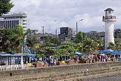 Seaside park near the main tourist jetty | |||
| |||
| Nickname(s): El Puerto (the Port) | |||
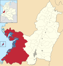 Location of the municipality and town of Buenaventura, Colombia in the Valle del Cauca Department of Colombia. | |||
 Buenaventura Location in Colombia | |||
| Coordinates: 3°52′38″N 77°1′36″W / 3.87722°N 77.02667°WCoordinates: 3°52′38″N 77°1′36″W / 3.87722°N 77.02667°W | |||
| Country |
| ||
| Department | Valle del Cauca Department | ||
| Region | Pacific Region of Colombia | ||
| Regional District | Special economic zone district | ||
| Foundation | 14 Julio de 1540 | ||
| Founded by | Juan Ladrillero by orden from Pascual de Andagoya | ||
| Government | |||
| • Mayor | Bartolo Valencia Ramos (Partido Liberal Colombiano) | ||
| • City Council |
List of Councillors
| ||
| Area | |||
| • Total | 6,078 km2 (2,347 sq mi) | ||
| Highest elevation | 7 m (23 ft) | ||
| Lowest elevation | 0 m (0 ft) | ||
| Population (2011 estimate) | |||
| • Total | 362,625 | ||
| • Rank | Ranked 19th | ||
| • Density | 60/km2 (150/sq mi) | ||
| Demonym(s) | Porteño, Bonaverense | ||
| Time zone | UTC-5 (Colombia Standard Time) | ||
| Area code(s) | 224 | ||
| Website |
www | ||


Buenaventura is a coastal seaport city on the department of Valle del Cauca, Colombia (South America). Buenaventura (Spanish for "good fortune") is the main port of Colombia in the Pacific Ocean.[1]
Buenaventura is a city with a population of 333,194[2] as of the 2005 census (most of city development lies on Cascajal Island) and it is the size of Los Angeles' metropolitan area; most of the city's land is rural with scattered small villages throughout. It is served by the Gerardo Tobar López Airport.
The city is part of the UNESCO Creative Cities Network after it was named "City of Gastronomy" in 2017.[3]
History
The city was founded on July 14, 1540, by Juan de Ladrilleros through orders from Pascual de Andagoya. At that time it was inhabited by the Buscajas. The city was destroyed by Native Americans before 1600; it was later rebuilt. Buenaventura thrived after the opening of the Panama Canal in 1914; and in the 1950s became a regular stopover for the 'international jet set'. Today, the city is crucial for sending raw materials to nearby areas; this has brought prosperity and allowed recent new development to occur.
Demographics
The city is, as of 2011, affected by very high levels of poverty and violence, and is considered a center for the cocaine trade in Colombia.[4]
Buenaventura's population is mostly of African descent (85%) with 10% mixed European/Native Indian and 5% Hispanic.
Transport
Port
The city is one of the major ports on the continent, accounting for nearly 60% of all Colombian sea imports and exports.[5] However, due to its strategic position, the city's economy has been hampered by gang-related activity fighting over control of the port, making it the most impoverished cities in Colombia.[5]
Rivers
The city is surrounded by an immense number of rivers, including: the Dagua; the Anchicayá; the Calima; the Raposo; the Mayorquín; the Cajambre; the Yurumanguí; and part of the right arm of the Naya River and part of the left arm of the River San Juan at its mouth. In addition, it has an enormous amount of streams and smaller rivers, such as Agua Clara, San Marcos, Sabaletas, San Cipriano and Escalerete, which supplies the municipal capital through a modern aqueduct.
Road
Well paved and maintained roads, that are designed to be unaffected by landslides, leave the city via Loboguerrero, where it divides to go to Cali, or Buga and then onwards to the cities of Armenia, Medellín and Bogotá. This route is known as "La Vía al Mar", as it connects large and different parts of the country together.
Airport
Gerardo Tobar López Airport connects Buenaventura with direct flights of 1 hour 20 minutes to Bogotá via Satena , as well as to other cities.
Crime
Buenaventura has had a notorious history plagued by the Colombian armed conflict, drug trafficking, violence, and the presence of guerrilla and paramilitary groups.[6]
Colombian authorities have seized almost US$28 million in cash from drug kingpins. The money found was in several shipping containers sent from Manzanillo, Colima (Mexico) and Houston (USA), that belonged to brothers Luis Enrique and Javier Antonio Calle Serna, also known as the ‘Combas’.[7][8]
Between 2008 and 2010, the number of reported homicides in the city doubled. In 2010, the murder rate of Buenaventura was 175.2 homicides per 100,000, a rate 24 times that of New York City. To counter the violence, the Colombian government has set up a marine special forces unit in the worst area of the city.[9] In 2011, it seemed that counter-violence efforts had improved crime metrics, even while aspects of the Colombian drug war in that city worsened. According to community activist Victor Hugo Vidal, "If you ask the authorities, they will tell you [the city] is better -- that the homicide rates are way down. But for us [living here], during the last 10 years, there has been no change."[10]
Education
Universities
The city hosts many higher education universities, both private and public:
Public
- Universidad del Valle - it is the leading academic institution in south-western Colombia, with the third-highest student population in the country. Its main campus is in the city of Cali, but apart from the capital of Valle del Cauca, there are campuses in Barrio San Fernando, where the Faculty of Health and the Faculty of Administration are based, and they have regional headquarters in: Buga, Cartago, Caicedonia, Northern Cauca, Buenaventura, Palmira, Tulua, Yumbo and Zarzal. In all its branches have in total more than 30,000 students (2007) of which almost 25,000 are undergraduates and 5,000 postgraduates. The headquarters of the Universidad del Valle in the city of Buenaventura, are on the Avenida Simon Bolivar km 9 Contiguo ITI College, GVC.
- Universidad del Pacífico - is a University Public Institution of Higher Education. It currently has five academic programs; Systems Engineering, Architecture, Sociology, Humid Tropics Agriculture, Aquaculture Technology, and Computer Technology. The administrative office is located at Avenida Simon Bolivar # 54A-10 in Buenaventura. It also has offices in Guapi and Tumaco.
- Universidad del Quindío
Private
- Universidad Antonio Nariño - one of the largest private universities in the country, with campuses in nearly all major cities in Colombia, including Buenaventura
Geography
Buenaventura is located a few miles from the western cordillera of the Andes mountain range and the major city of Cali, the department's capital. It is one of the rainiest cities in the world, with 6000–7000 mm of precipitation annually.
Climate
| Climate data for Buenaventura | |||||||||||||
|---|---|---|---|---|---|---|---|---|---|---|---|---|---|
| Month | Jan | Feb | Mar | Apr | May | Jun | Jul | Aug | Sep | Oct | Nov | Dec | Year |
| Record high °C (°F) | 33 (91) |
37.0 (98.6) |
37.0 (98.6) |
37.0 (98.6) |
36.0 (96.8) |
37.0 (98.6) |
39.0 (102.2) |
35.4 (95.7) |
35.6 (96.1) |
35.8 (96.4) |
34.0 (93.2) |
35.6 (96.1) |
39 (102.2) |
| Average high °C (°F) | 32.8 (91) |
33.3 (91.9) |
33.9 (93) |
34.1 (93.4) |
33.4 (92.1) |
33.2 (91.8) |
33.2 (91.8) |
32.8 (91) |
33.2 (91.8) |
32.8 (91) |
32.3 (90.1) |
32.7 (90.9) |
33.1 (91.6) |
| Daily mean °C (°F) | 25.9 (78.6) |
25.9 (78.6) |
26.1 (79) |
26.2 (79.2) |
26.0 (78.8) |
25.8 (78.4) |
26.0 (78.8) |
25.7 (78.3) |
25.6 (78.1) |
25.6 (78.1) |
25.7 (78.3) |
25.6 (78.1) |
25.8 (78.5) |
| Average low °C (°F) | 19.7 (67.5) |
20.0 (68) |
19.9 (67.8) |
20.1 (68.2) |
19.9 (67.8) |
19.7 (67.5) |
20.0 (68) |
20.0 (68) |
19.7 (67.5) |
20.0 (68) |
19.6 (67.3) |
19.0 (66.2) |
19.8 (67.6) |
| Record low °C (°F) | 14.4 (57.9) |
15.4 (59.7) |
14.6 (58.3) |
14.6 (58.3) |
16.2 (61.2) |
15.1 (59.2) |
13.6 (56.5) |
13.4 (56.1) |
14.2 (57.6) |
15.0 (59) |
15.1 (59.2) |
15.0 (59) |
13.4 (56.1) |
| Average precipitation mm (inches) | 330.8 (13.024) |
264.2 (10.402) |
347.2 (13.669) |
468.3 (18.437) |
606.9 (23.894) |
501.2 (19.732) |
530.8 (20.898) |
578.2 (22.764) |
724.2 (28.512) |
803.3 (31.626) |
639.1 (25.161) |
481.4 (18.953) |
6,275.6 (247.072) |
| Average precipitation days | 19 | 16 | 19 | 19 | 24 | 23 | 24 | 25 | 25 | 25 | 24 | 21 | 264 |
| Average relative humidity (%) | 87 | 86 | 86 | 86 | 86 | 87 | 86 | 88 | 88 | 87 | 86 | 86 | 87 |
| Source: Instituto de Hidrologia Meteorologia y Estudios Ambientales[11] | |||||||||||||
Tourism
The city has several places of interest.
The most notable tourist venue is the Cascajal Island. This island is located in the western part of the city of Buenaventura, it is inhabited, and is surrounded by marshes and in it are important tourist and commercial sites, making it an important source of income. Among its most important tourist attractions we can mention: the park Néstor Urbano Tenorio, the field of handicrafts sea of the same, the cathedral San Buenaventura Hotel Station, the ramp or site boats to go to nearby islands and finally the pier, from where over 70% of commerce happens.
The San Cipriano reserve, which actual name is "Protective Forest Reserve Escalarete Rivers and San Cipriano", covers an area of 8564 hectares and to get them you have to get to Cordoba is 20 km before Buenaventura and Córdoba, to the reserve are 20 minutes witches (these are carts ball bearings operating in the railway tracks) or carromotor in the reserve are deep pools and transparent waters, frills, great diversity of fauna and flora, typical dishes of the region, fruits and liquors representative of this and most importantly friendly and respectful people.
Juanchaco and Ladrilleros beaches are located at the entrance of Bahía Málaga an hour by boat from Buenaventura, located south of the Colombian Pacific, where flowing rivers, there are fishing villages in the middle of a dense forest of mangroves live and work lilting rhythm marimba and drum. There, between Buenaventura and Bahía Málaga are vast beaches of great beauty, with good tourist infrastructure, as Ladrilleros and Juanchaco, with much culture and tradition, which are visited by tourists. The Bocana: is a coastal town that is before reaching Ladrilleros, the beaches are beautiful, it is a good fishing sector has a lot of culture, the people are friendly and the dishes are delicious. There are also comfortable cabins and nature trails showing its great biodiversity.
Piangüita, which is near Buenaventura is a coastal town, where the sea meets the sky in dreamy sunsets, is the Ecoparque Theme Green Iguanas, it becomes a community effort to revive tourism, as Rigoberto Gomez, creator of the place. The Ecopark, comprising four hectares, is part of the habitat of the black community Bazán, "who designed nature trails to show tourists their way of life, fauna and flora, and how it has been recording their culture." It also has beautiful beaches which attracts many tourists.
Bahía Málaga is a deepwater port designed to provide support to large shippers to ship next generation that can not enter the port of Buenaventura, alternate port of private capital for public service.
La Barra is the last beach after Pianguita, Juanchaco and Ladrilleros. To reach this beautiful beach you have to go by boat and then take ground transportation. There are several hostels near to stay and nature trails to admire the vegetation and biodiversity of the place.
Major places of interest
- Cathedral of Buenaventura
- National Palace
- San Cipriano and Escalarete rivers Nature Reserve.
- Beaches of La Bocana, Piangüita, Juanchaco, Ladrilleros and La Barra
- Hotel Maguipi
- Botanical Garden Bushes, within the area of Bahía Málaga Uramba National Natural Park
Minor places of interest
- Néstor Urbano Tenorio Park
- Several viewpoints towards the sea.
- Tourist floating dock.
- Mural "Buenaventura 450 years in space"
- Spa on the outskirts of the city
- Hotel Station
Notable natives and residents
- Edison Miranda, a 2000 Colombia Olympian, former WBO Latino, NABA, and IBF Latino Middleweight champion
- Juan Carlos Candelo, former NABF Light Middleweight champion
- Freddy Rincón, retired Colombian football midfielder
- Gerardo Valencia Cano, Apostolic vicariate de Buenaventura
- Adolfo Valencia, retired Colombian football striker
- Raul Cuero, professor of microbiology at Prairie View A&M University and Inventor
- Petronio Álvarez Quintero, singer-songwriter Currulao
- Fernando Montaño, soloist with the Royal Ballet in London
- Jairo Andres Lerma Payan, comedian, civil rights leader raised in USA, Anti Police Brutality, End War on Drugs, DACA rescipient fighting for Immigration reform Borough of Manhattan Community College Alumni
- Marbelle, pop singer
Sport
The city has had two professional football teams; each club played Categoría Primera B and had only a short existence. Pacífico F.C. only existed for the 2010-2011 season, whereas Atlético Buenaventura played between 1991 and 1995.
References
- ↑ Kraul, Chris (21 September 2009). "Colombian crackdown appears to be paying off". Retrieved 19 April 2018 – via LA Times.
- ↑ "World Gazetteer: Buenaventura - profile of geographical entity includ…". world-gazetteer.com. 9 February 2013. Archived from the original on 9 February 2013. Retrieved 19 April 2018.
- ↑ "Once Colombia's 'Deadliest City,' Buenaventura Is Coming Back". Retrieved 2018-10-03.
- ↑ Otis, John (27 April 2011). "DIY subs join Colombia's cocaine trade". Retrieved 19 April 2018 – via www.bbc.co.uk.
- 1 2 "Buenaventura: Dismemberment and Displacement (Full Length) - VICE News". VICE News. Retrieved 19 April 2018.
- ↑ "Colombia's new urban drugs war". 18 August 2007. Retrieved 19 April 2018 – via news.bbc.co.uk.
- ↑ http://colombiareports.com/colombia-news/news/5946-colombian-authorities-hauled-drug-money-almost-us-28-million.html
- ↑ "U.S. Targets Powerful, Profitable "Super Cartel"". cbsnews.com. Retrieved 19 April 2018.
- ↑ Reuters (24 March 2010). "Bomb Kills at Least 6 in Port City in Colombia". Retrieved 19 April 2018 – via NYTimes.com.
- ↑ Dickinson, Elizabeth. "Colombia's Invisible War". theatlantic.com. Retrieved 19 April 2018.
- ↑ "Climate of Buenaventura -Table of Values" (in Spanish). Instituto de Hidrologia Meteorologia y Estudios Ambientales. Retrieved September 6, 2012.
External links

