Buckland Bund
Buckland Bund (Bengali: বাকল্যানড বাঁধ) is a historically significant architectural creation situated by the Buriganga river bank of Old Dhaka, Bangladesh. It was constructed by Charles Thomas Buckland in 1864 who was the commissioner of Dhaka during that period.[1]
History
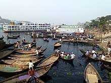
There was no expansion of the city south of the river, but the riverfront itself grew to be the most pleasing and beautiful part of the town. In Dhaka there had always been a tendency to live near the river. As it was the principal means of communication with the other parts of the country, river frontages were commercially valuable and the river itself was a major source of water supply. Only after the coming of the railway, a piped water supply and electricity for fans and coolers did the riverfront of Dhaka lose its prime importance as a residential locality. Prior to these developments, most of the rich inhabitants of the city had their residences here, and all the most elegant houses and buildings of Dhaka fronted the Buriganga. The magnificent houses of the zamindars, merchants and other richer people, the fine residences of European officials, the remnants of the majestic Lalbagh Fort, the old buildings of Bara Katra and Chota Katra, the domes and minarets of several beautiful mosques upon the edge of the river, gave to Dhaka, as the traveler approached it, the look of a city rising from the sea. The river was also however, a source of problems. It was tidal, so that at low tide, it exposed a foreshore which was muddy and noisome, causing great difficulties to those crossing the river or loading and unloading cargo.[2][3]
Charles Thomas Buckland was appointed the commissioner of Dhaka 1864 and he had a very successful tenure at this post for 5 years. Azimush-Shan built a palace for himself in Posht on the bank of Buriganga which was situated about 400 yards away from Lalbagh Fort. The palace is now washed up by the river, but the embankment was visible for a long time. This embankment goes right eastward and terminates at Babubazar Khal. It is clearly visible when passing by boats. According to Rennel, this bund in 1765 extended four miles northeast to southwest. Even though there was already a bund by the Buriganga river bank from the Mughal period, it was Buckland who took the initiative to build a metaled road over it. That is how the road by the riverbank came to be known as the Buckland Bund which is almost one mile long, from Farashganj (French Town) to Babu Bazaar.[4][5]
In 1864, to protect the shore from flooding and erosion, to prevent the formation of great mudflats at low tide, and to facilitate the movement of passenger and cargo at the river ghats Buckland launched a scheme to construct an embankment along the southern front of the city. He also planned a promenade behind the bund to beautify the waterfront and provide a pleasure walk. Accordingly, he convened a meeting of influential residents, explained to them the benefits that would accrue from the embankment told them that he wanted funds for it.[4][6]
Initially Buckland collected the funds to build the bund from Dhaka’s well established and rich people amongst whom were Khwaja Abdul Ghani, the zamindar of Bhawal Kali Narayan Rai, Jagannath Rai Chowdhury and Mohinimohon Dash. In Nazir Hossain’s Book “Kingbodontir Dhakai” he mentioned Bhutto Hazi as well as one of the financial contributors. Buckland started the construction work with the collection of tk.65, 000 but unfortunately he could not finish the work during his reign of 5 years as the commissioner as he had to leave Dhaka and as believe by many, it was probably Simson the next commissioner finished the work of Buckland Bund. It is said that the fund collected by Mr. Buckland was not enough to finish the construction work, hence his successor Simson arranged more tk.10,000 from the local fund and borrowed tk.8,000 from Khwaja Abdul Gani Miyah to continue the work even though there was still a little financial shortage. Seeing this, Khwaja Abdul Ghani donated Tk.2,000 more to help the cause and tk.2, 000 more was collected as tax from Mohini Mohon Dash to arrange the rest of the fund.[4][7] A few more information was collected from the autobiography of Hridoynath Mojumder.[8] According to him, during the first year of construction the road was built from Northbrook Hall to Owaiz Ghat and in the next year it was built from Ruplal House to Badamtoli Ghat.[9] The east side was completed with the donation of Ruplal Dash and the west side was completed with the donation of Nawab Abdul Gani whereas the middle part was built with the donation of the government.[8]
Architectural significance
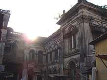
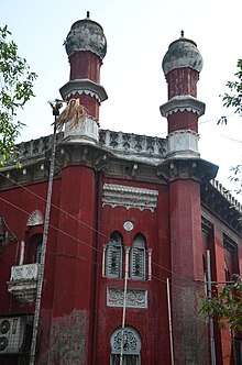
Buckland Bund was a place for recreation and passing time for local people not only in the 19th century but also in the beginning decades of the 20th century. It was a very attractive place to visit for the middle class local people of that time. During C. T. Buckland’s period, under government initiative a lot of buildings and significant architectural creations took place in Dhaka. In fact, during the time of his leaving he was offered an “Appreciation Certificate” from the communities of Muslims, Hindus, Armenians and English which unfortunately he could not accept due to not having such permission from the government. Buckland Bund was a new gathering place for the people of Dhaka as the view of the river was an amazing piece of recreation for them. According to the autobiography of Ridoai Nath Mojhumder, 12 steel benches were provided there at first which were not sufficient so 8 more benches were added. The crowd visiting the Buckland Bund at that time proved that it was a very refreshing place and even today after almost 300 years the place is still used as a social gathering place by the local people.[4][10] The construction of the bund quickly transformed the area into a very posh place and a lot of zamindars started to erect their mansions on and around this bund. The embankment was fortified with stone, and the top laid with bricks. Near Sadarghat, part of the strand was left green, and was later turned into a miniature park with a raised dais where visiting dignitaries could be received on landing from steamers and where a local regimental band played daily in the afternoon for the entertainment of the people. The strand became an attraction to the city and a boon and was used as a promenade overlooking the river with its busy traffic, where people could stroll in the afternoon and evening while enjoying the cool breeze from the river.[11][3][12]
Present condition
Buckland Bund was a very elegant riverfront of Dhaka[13] in the 1900 but has since deteriorated. During the reign of Ayub Khan, the rights of the bund was transferred to the government from the public in 1963, the bund’s maintenance and beauty started to deteriorate.[14][15][16]
References
- ↑ Rahman, S M Mahfuzur. "Buckland Bund". Banglapedia. Retrieved 9 August 2015.
- ↑ Taifoor, Syed Muhammed (1965). Glimpses of Old Dhaka: a short historical narration of East Bengal and Aassam. S. M. Perwez.
- 1 2 Ahmed, Sharif Uddin (2003). Dhaka: a study in urban history and development, 1840-1921. Academic Press and Publishers. p. 144. ISBN 9789843209597.
- 1 2 3 4 "Buckland Bund - Banglapedia". en.banglapedia.org. Retrieved 2018-01-04.
- ↑ "Farashganj, a lost history | Dhaka Tribune". www.dhakatribune.com. Retrieved 2018-01-04.
- ↑ 1951-, Māmuna, Munatāsīra, (1993). Ḍhākā smr̥ti bismr̥tira nagarī (Prathama Prakāśa ed.). Ḍhākā: Ananyā. ISBN 9844121043. OCLC 45260385.
- ↑ "Ghani, Nawab Khwaja Abdul - Banglapedia". en.banglapedia.org. Retrieved 2018-01-04.
- 1 2 Majumdar, Hriday Nath (1926). The Reminiscences of Dacca.
- ↑ "Save Ruplal House (video)". The Daily Star. 2015-11-20. Retrieved 2018-01-04.
- ↑ "Star Magazine". archive.thedailystar.net. Retrieved 2018-01-04.
- ↑ "Eateries of Dacca". The Daily Star. 2013-08-02. Retrieved 2018-01-04.
- ↑ Jamil, Syed Maqsud (2011-02-08). "And so this is Buriganga". Archived from the original on 8 February 2011. Retrieved 2018-01-04.
- ↑ (India), Bengal (1912). Bengal district gazetteers. p. 174.
- ↑ "Sights, sounds, a lost era". The Daily Star. 2008-09-06. Retrieved 2018-01-04.
- ↑ Chatterjee, Partha (2004). A Princely Impostor?: The Kumar of Bhawal and the Secret History of Indian Nationalism. Permanent Black. ISBN 9788178240848.
- ↑ Commissioner, Pakistan Office of the Census (1961). Population Census of Pakistan, 1961. Ministry of Home Affairs. p. 44.
Coordinates: 23°41′13.1″N 90°23′49.1″E / 23.686972°N 90.396972°E