Bryn Eglwys
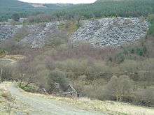 Spoil heaps at the disused Bryn Eglwys quarry, 2008 | |
| Location | |
|---|---|
 Bryn Eglwys | |
| Location | near Abergynolwyn |
| County | Gwynedd |
| Country | Wales |
| Coordinates | 52°38′0″N 3°55′53″W / 52.63333°N 3.93139°WCoordinates: 52°38′0″N 3°55′53″W / 52.63333°N 3.93139°W |
| Production | |
| Products | Slate |
| Type | Quarry |
| History | |
| Opened | 1840 |
| Closed | 1946 |
Bryn Eglwys was a slate quarry and mine located near Abergynolwyn in Gwynedd, Wales. More than 300 men worked at the site making it the principal employer in the area. Two veins of slate, known as the Broad and Narrow Veins, were worked. The geology continues across the mountains to Corris and Dinas Mawddwy. It was one of many quarries that worked the same geological feature because the slate went through sedimentary rock that suited mining.
The site, which was in operation for just over a 100 years, covered almost 2 sq mi (5.2 km2). It had several long tunnels up to 250 m (820 ft) to 350 m (1,150 ft). However, since closure all buildings have been demolished. Most of its inclines and infrastructure have become part of forestry plantations.
History
The quarry was first worked on a small scale in the early 1840s. In 1864 William McConnel leased the quarry, forming the Aberdovey Slate Company Limited. McConnel planned to increase production at Bryn Eglwys. The limiting factor was the transportation of finished slates by pack horse to the wharves at Aberdyfi. To overcome this, McConnel built the Talyllyn Railway, a narrow gauge line running from the quarry to Tywyn, where slate could be transhipped to the newly built Aberystwyth and Welsh Coast Railway.[1]
The Talyllyn Railway ran to Nant Gwernol, a lonely spot about 430 feet below the main quarry level. From there the half-mile long Galltymoelfre Tramway and a pair of inclines connected to the quarry.
Neither the quarry nor its associated railway were great commercial successes. By 1879 the company had run out of funds and both were put up for auction on 9 October 1879. After this and a subsequent auction failed to find a bidder, William McConnel personally bought both, and an upturn in the slate market allowed the quarry to expand further.
McConnel died in 1902 and the quarry became the property of his son W.H. McConnel. However the leases on the land the quarry occupied were close to running out and Bryn Eglwys ceased production in 1909.
In 1911 the local Liberal Member of Parliament Henry Haydn Jones purchased the quarry, along with the Talyllyn Railway and the village of Abergynolwyn, forming the Abergynolwyn Slate & Slab Co. Ltd. New leases were signed with the landowners and the quarry resumed production.
The quarry remained in production until a serious collapse on 26 December 1946 - it had been unsafe for some time.
Geology

Three parallel veins of Ordovician[2] slate run through mid Wales, from the region north of Dinas Mawddwy through Corris and south west towards Tywyn. These veins are the southern edge of the Harlech Dome anticline which surfaces in the north at Blaenau Ffestiniog.[2] Where the veins cross the site of Bryn Eglwys, they are inclined at an angle of about 30 degrees from the horizontal, sloping downwards to the south-west. The widest of these veins is the 600-ft-thick "Broad Vein" that lies to the north of the site and consists of layers of hard, grey shale with patches of slate. The Broad Vein slate is hard and durable, but does not split into thin sections, so is generally unsuitable for use as roofing slates.[3]
The "Middle Vein" (sometimes known as the "Red Vein") lies about 100 yards south of the Broad Vein. It is about 60 ft thick but contains low-quality, friable slate that contains a large number of fossils, predominately graptolites. [4] This vein was not worked commercially at Bryn Eglwys.[3]
The third vein is the "Narrow Vein" which lies about 100 yards south of the Middle Vein and is also about 60 ft thick. It contains the highest quality slate of the three veins and the most commercially valuable, being easy to split into roofing slates and slabs and both durable and strong. The vein is mostly a continuous bed of slate, containing only the occasional seam of quartz. However the quality of the rock varies over the depth of the vein, with the best material found nearest the surface.[3]
Description


References
- ↑ Boyd, James I.C. (1988). The Talyllyn railway. Wild Swan Publications Ltd. ISBN 0-906867-46-0.
- 1 2 Richards, Alun John (1999). The Slate Regions of North and Mid Wales, and their Railways. Carreg Gwalch. ISBN 0-86381-552-9.
- 1 2 3 Rolt, L.T.C. (1965). Talyllyn Century. David & Charles.
- ↑ Blackie, R. C. (1927). "The Geology of the Country between Llanelidan and Bryneglwys". Quarterly Journal of the Geological Society. 83: 711–736. doi:10.1144/GSL.JGS.1927.083.01-05.29.
| Wikimedia Commons has media related to Bryn Eglwys. |
External links
| Main articles | ||
|---|---|---|
| Locomotives | ||
| Locations | ||
| People | ||
| Miscellaneous | ||