Aberystwith and Welsh Coast Railway
| Aberystwith and Welsh Coast Railway | |
|---|---|
| Overview | |
| Locale | Wales |
| Continues as | Cambrian Railways |
| Operation | |
| Opened | 1 July 1863 |
| Closed | 5 August 1866 |
| Technical | |
| Line length | 86 miles (138 km) |
| Track gauge | 4 ft 8 1⁄2 in (1,435 mm) |
| Aberystwith & Welsh Coast Railway |
|---|
The Aberystwith and Welsh Coast Railway was a standard gauge railway built in 1863 connecting major towns around Cardigan Bay in Wales.

History
The Aberystwith and Welsh Coast Railway was authorised by a Private Act of Parliament in 1861.[1] The Act permitted the construction of a railway around Cardigan Bay between the towns of Aberystwyth (then spelled Aberystwith), Barmouth, Porthmadog, and Pwllheli. Its northern terminus was to be Porthdinllaen near Nefyn on the north coast of the Lleyn Peninsula. The plan also included a link with the Newtown and Machynlleth Railway by means of a line from Machynlleth to Ynyslas on the southern shore of the Dyfi estuary opposite Aberdyfi, the Dyfi itself to be bridged at this point.
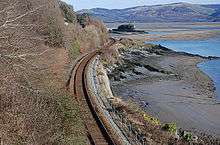
Work began at Machynlleth, and the line was opened through to Aberystwyth in 1864. However, the planned Dyfi bridge at Ynyslas proved impracticable, requiring the divergence between the Aberystwyth and Coast lines to be moved 6 miles east to Dyfi Junction. This added 12 miles to the journey north from Aberystwyth, but the twisting line – just a few feet above high tide level - between Dyfi Junction and Aberdyfi remains one of the most scenic sections of railway in Britain. For a time before completion, southbound passengers detrained at Aberdyfi and were carried over to Ynyslas by ferry, for which a short temporary branch was built for use at low tide.
Very soon after construction began, the proposed terminus at Porthdinllaen was abandoned. The 5-mile surveyed route across the Lleyn Peninsula was never built. The company decided that services would stop at the line's new terminus at Pwllheli.
Major works on the line included the bridge south of Barmouth and the cliff top line at Friog. This latter location was the site of two almost identical accidents, in 1883 and 1933, in which the locomotive plunged to the foot of the cliff leaving the bulk of the train remaining on the track. The locomotive crews were killed in both instances. The topography at this point is demanding, as the existing coast road at a higher level had to be accommodated, as well as a working mine.
The line was extended from Barmouth to Pwllheli via Porthmadog (then Portmadoc) in 1867, the year after it was absorbed into the Cambrian Railways.[2] The company's correct name - as in the five Private Acts of Parliament it obtained during its life - was spelled "Aberystwith": widespread erroneous use (including even the above cited reference) of the modern "Aberystwyth" spelling stems from mis-transcription in official records, now online. The newer spelling started to come into use in the mid-19th century: Bradshaw's railway timetable commenced using it from c. 1868 but the Cambrian Railways did not adopt the new spelling until April 1892; the older version is still to be found in press references in the early years of the 20th century.
Current operations
The majority of the line is open except the line between Morfa Mawddach and Dolgellau which closed on 18 January 1965.
A ten-mile (16 km) section between Barmouth Junction and Dolgellau is also used as the Llwybr Mawddach (or "Mawddach Trail"), a cycle route and bridleway. Conversion of the trackbed to a path was incidentally assisted in 1976 when heavy floods washed away most of the remaining ballast. This section of the line featured in the BBC's Railway Walks series with Julia Bradbury.[3]
Connections to other lines
References
- ↑ "Acts of the Parliaments of the United Kingdom Part 50 (1861)". www.legislation.gov.uk. Retrieved 4 October 2018.
- ↑ Christiansen, Rex & Miller, R.W. The Cambrian Railways, Vol. 1 David & Charles (1967); p 65
- ↑ "Archived copy". Archived from the original on 26 November 2011. Retrieved 2011-09-13.
- Awdry, Christopher (1990). Encyclopaedia of British Railway Companies. Sparkford: Patrick Stephens Ltd. ISBN 1-8526-0049-7. OCLC 19514063. CN 8983.
- Jowett, Alan (March 1989). Jowett's Railway Atlas of Great Britain and Ireland: From Pre-Grouping to the Present Day (1st ed.). Sparkford: Patrick Stephens Ltd. ISBN 978-1-85260-086-0. OCLC 22311137.