Broxted
| Broxted | |
|---|---|
 Broxted Broxted shown within Essex | |
| Population | 508 (2011)[1] |
| OS grid reference | TL578270 |
| Civil parish |
|
| District | |
| Shire county | |
| Region | |
| Country | England |
| Sovereign state | United Kingdom |
| Post town | DUNMOW |
| Postcode district | CM6 |
| Dialling code | 01279 |
| Police | Essex |
| Fire | Essex |
| Ambulance | East of England |
| EU Parliament | East of England |
| UK Parliament | |
Broxted is a village and civil parish in the Uttlesford district, in the county of Essex, England. It is situated 11 km (6.8 mi) north-east from Bishop's Stortford, Hertfordshire and 23 km (14 mi) north-west from the county town of Chelmsford.
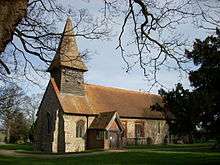
St Mary's Church, Broxted
The parish includes the hamlets of Cherry Green and Brick End.
Broxted is in the parliamentary constituency of Saffron Walden. There is a Parish Council.[2] According to the 2001 census it had a population of 526,[3] reducing to 508 at the 2011 Census.[1] The village lies on the road between Molehill Green and Thaxted. It has one public house, the Prince of Wales. In the 16th and 17th centuries, part of Broxted was known as Chawreth.[4]
See also
References
- 1 2 "Civil Parish population 2011". Neighbourhood Statistics. Office for National Statistics. Retrieved 27 September 2015.
- ↑ "Uttlesford Information regarding Broxted". www.uttlesford.gov.uk. Archived from the original on September 27, 2007. Retrieved 2007-03-14.
- ↑ Neighbourhood statistics
- ↑ "Historical Gazetteer: Broxted". www.placenames.org.uk. The Historical Gazetteer of England's Place Names. Retrieved 18 February 2016.
External links

- Official Broxted Website, supported by Broxted Parish Council
This article is issued from
Wikipedia.
The text is licensed under Creative Commons - Attribution - Sharealike.
Additional terms may apply for the media files.