Brookridge, Florida
| Brookridge, Florida | |
|---|---|
| Census-designated place | |
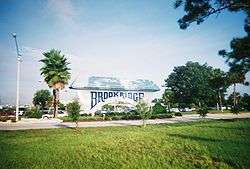 The gateway to Brookridge on State Road 50 | |
 Location in Hernando County and the state of Florida | |
| Coordinates: 28°32′55″N 82°29′26″W / 28.54861°N 82.49056°WCoordinates: 28°32′55″N 82°29′26″W / 28.54861°N 82.49056°W | |
| Country | United States |
| State | Florida |
| County | Hernando |
| Area | |
| • Total | 2.5 sq mi (6.5 km2) |
| • Land | 2.5 sq mi (6.5 km2) |
| • Water | 0 sq mi (0 km2) |
| Elevation | 62 ft (19 m) |
| Population (2010) | |
| • Total | 4,420 |
| • Density | 1,767/sq mi (682.4/km2) |
| Time zone | UTC-5 (Eastern (EST)) |
| • Summer (DST) | UTC-4 (EDT) |
| FIPS code | 12-08762[1] |
| GNIS feature ID | 1867119[2] |
Brookridge is a census-designated place (CDP) in Hernando County, Florida, United States. The population was 4,420 at the 2010 census,[3] up from 3,279 at the 2000 census.
Geography
Brookridge is located in central Hernando County at 28°32′55″N 82°29′26″W / 28.54861°N 82.49056°W (28.548698, -82.490423).[4] It is bordered to the east by Florida State Road 589 (the Suncoast Parkway), to the south across Florida State Road 50 by Spring Hill, and to the west by High Point. SR 589 leads south 50 miles (80 km) to Tampa and north 10 miles (16 km) to its terminus at U.S. Route 98 near Sugarmill Woods. SR 50 leads east 6 miles (10 km) to Brooksville, the Hernando County seat, and west 5 miles (8 km) to U.S. Route 19 at Weeki Wachee.
According to the United States Census Bureau, the Brookridge CDP has a total area of 2.5 square miles (6.5 km2), all land.[3]
Demographics
As of the census[1] of 2000, there were 3,279 people, 1,823 households, and 1,168 families residing in the CDP. The population density was 1,617.7 people per square mile (623.7/km²). There were 2,129 housing units at an average density of 1,050.4/sq mi (404.9/km²). The racial makeup of the CDP was 98.87% White, 0.15% African American, 0.09% Native American, 0.18% Asian, 0.21% from other races, and 0.49% from two or more races. Hispanic or Latino of any race were 0.95% of the population.
There were 1,823 households out of which 2.5% had children under the age of 18 living with them, 59.0% were married couples living together, 4.0% had a female householder with no husband present, and 35.9% were non-families. 33.5% of all households were made up of individuals and 29.0% had someone living alone who was 65 years of age or older. The average household size was 1.76 and the average family size was 2.14.
In the CDP, the population was spread out with 2.9% under the age of 18, 1.3% from 18 to 24, 5.4% from 25 to 44, 19.0% from 45 to 64, and 71.4% who were 65 years of age or older. The median age was 72 years. For every 100 females, there were 82.0 males. For every 100 females age 18 and over, there were 81.4 males.
The median income for a household in the CDP was $24,774, and the median income for a family was $30,139. Males had a median income of $19,519 versus $15,194 for females. The per capita income for the CDP was $18,122. About 4.2% of families and 5.7% of the population were below the poverty line, including none of those under age 18 and 5.7% of those age 65 or over.
References
- 1 2 "American FactFinder". United States Census Bureau. Archived from the original on 2013-09-11. Retrieved 2008-01-31.
- ↑ "US Board on Geographic Names". United States Geological Survey. 2007-10-25. Retrieved 2008-01-31.
- 1 2 "Geographic Identifiers: 2010 Demographic Profile Data (G001): Brookridge CDP, Florida". American Factfinder. U.S. Census Bureau. Retrieved April 26, 2017.
- ↑ "US Gazetteer files: 2010, 2000, and 1990". United States Census Bureau. 2011-02-12. Retrieved 2011-04-23.
Municipalities and communities of Hernando County, Florida, United States | ||
|---|---|---|
| Cities | 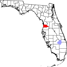 | |
| CDPs | ||
| Unincorporated community | ||