Broadview, New Mexico
| Broadview, New Mexico | |
|---|---|
| Unincorporated community | |
 Broadview Location within the state of New Mexico  Broadview Broadview (the US) | |
| Coordinates: 34°49′10″N 103°12′49″W / 34.81944°N 103.21361°WCoordinates: 34°49′10″N 103°12′49″W / 34.81944°N 103.21361°W | |
| Country | United States |
| State | New Mexico |
| County | Curry |
| Elevation | 4,514 ft (1,376 m) |
| Time zone | UTC-7 (Mountain (MST)) |
| • Summer (DST) | UTC-6 (MDT) |
| ZIP codes | 88112 |
| Area code(s) | 575 |
| GNIS feature ID | 886744[1] |
Broadview is an unincorporated community located in Curry County, New Mexico, United States. Broadview is located at the junction of New Mexico State Road 209, New Mexico State Road 241, and New Mexico State Road 275 28.5 miles (45.9 km) north of Clovis. Broadview has a post office with ZIP code 88112.[2][3]
References
- ↑ "Broadview". Geographic Names Information System. United States Geological Survey.
- ↑ United States Postal Service. "USPS - Look Up a ZIP Code". Retrieved July 31, 2014.
- ↑ "Postmaster Finder - Post Offices by ZIP Code". United States Postal Service. Retrieved July 31, 2014.
Municipalities and communities of Curry County, New Mexico, United States | ||
|---|---|---|
| Cities | 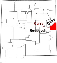 | |
| Villages | ||
| CDP | ||
| Unincorporated communities | ||
This article is issued from
Wikipedia.
The text is licensed under Creative Commons - Attribution - Sharealike.
Additional terms may apply for the media files.