Bellview, New Mexico
| Bellview, New Mexico | |
|---|---|
| Unincorporated community | |
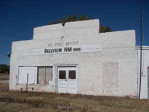 Abandoned post office in Bellview | |
 Bellview Location within the state of New Mexico  Bellview Bellview (the US) | |
| Coordinates: 34°49′16″N 103°06′28″W / 34.82111°N 103.10778°WCoordinates: 34°49′16″N 103°06′28″W / 34.82111°N 103.10778°W | |
| Country | United States |
| State | New Mexico |
| County | Curry |
| Elevation | 4,455 ft (1,358 m) |
| Time zone | UTC-7 (Mountain (MST)) |
| • Summer (DST) | UTC-6 (MDT) |
| ZIP codes | 88112[1] |
| Area code(s) | 575 |
| GNIS feature ID | 915801[2] |
Bellview is an unincorporated community located in Curry County, New Mexico, United States. Bellview lies on the High Plains of the Llano Estacado at an altitude of 4,455 feet (1,358 m) above sea level.[2] It is located 12 miles (19 km) east of Grady, 6 miles (9.7 km) east of Broadview, and 29.5 miles (47.5 km) north of Clovis. New Mexico State Road 241 runs east–west through town. Bellview had its own post office until it closed on April 22, 1995.[3] Today, the town is mostly abandoned and approaching ghost-town status.
References
- ↑ United States Postal Service. "USPS - Look Up a ZIP Code". Retrieved July 31, 2014.
- 1 2 "Bellview". Geographic Names Information System. United States Geological Survey.
- ↑ "Postmaster Finder - Post Offices by ZIP Code". United States Postal Service. Retrieved July 31, 2014.
External links
Municipalities and communities of Curry County, New Mexico, United States | ||
|---|---|---|
| Cities | 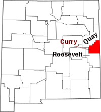 | |
| Villages | ||
| CDP | ||
| Unincorporated communities | ||
This article is issued from
Wikipedia.
The text is licensed under Creative Commons - Attribution - Sharealike.
Additional terms may apply for the media files.