Bristol, Vermont
| Bristol, Vermont | |
|---|---|
| Town | |
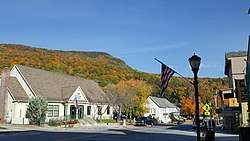 Main Street in Bristol in the fall | |
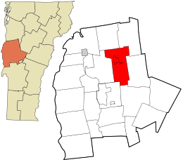 Location in Addison County and the state of Vermont. | |
| Coordinates: 44°8′0″N 73°4′46″W / 44.13333°N 73.07944°WCoordinates: 44°8′0″N 73°4′46″W / 44.13333°N 73.07944°W | |
| Country | United States |
| State | Vermont |
| County | Addison |
| Chartered | 1762 |
| Settled | 1783 |
| Organized | 1789 |
| Communities |
Bristol Rocky Dale |
| Government | |
| • Town Administrator | Therese Kirby |
| • Selectboard Chair | John "Peeker" Heffernan |
| • Selectboard | Joel Bouvier, Sharon Compagna, Michelle Perlee, Brian Fox |
| Area | |
| • Total | 42.2 sq mi (109.2 km2) |
| • Land | 41.5 sq mi (107.5 km2) |
| • Water | 0.7 sq mi (1.7 km2) |
| Elevation | 522 ft (159 m) |
| Population (2010) | |
| • Total | 3,894 |
| • Density | 94/sq mi (36.2/km2) |
| Time zone | UTC-5 (Eastern (EST)) |
| • Summer (DST) | UTC-4 (EDT) |
| ZIP code | 05443 |
| Area code | 802 |
| FIPS code | 50-09025[1] |
| GNIS feature ID | 1462053[2] |
| Website |
www |
Bristol is a town in Addison County, Vermont, United States. The town was founded June 26, 1762. The population was 3,894 at the 2010 census.[3] Main Street is home to most of the businesses of the town. The town is also home to the Lord's Prayer Rock.[4]
Geography
Bristol is in northeastern Addison County, at the western foot of the Green Mountains. The New Haven River, a tributary of Otter Creek, flows out of the mountains through the town center. The town is crossed by Vermont Route 17 (east-west) and Vermont Route 116 (north-south).
According to the United States Census Bureau, the town has a total area of 42.2 square miles (109.2 km2), of which 41.5 square miles (107.5 km2) is land and 0.66 square miles (1.7 km2), or 1.57%, is water.[3]
The main settlement in the town is Bristol, a census-designated place, located on the north side of the New Haven River, northwest of the geographic center of town.
Demographics
| Historical population | |||
|---|---|---|---|
| Census | Pop. | %± | |
| 1790 | 211 | — | |
| 1800 | 665 | 215.2% | |
| 1810 | 1,179 | 77.3% | |
| 1820 | 1,051 | −10.9% | |
| 1830 | 1,274 | 21.2% | |
| 1840 | 1,233 | −3.2% | |
| 1850 | 1,344 | 9.0% | |
| 1860 | 1,355 | 0.8% | |
| 1870 | 1,365 | 0.7% | |
| 1880 | 1,579 | 15.7% | |
| 1890 | 1,828 | 15.8% | |
| 1900 | 2,061 | 12.7% | |
| 1910 | 2,005 | −2.7% | |
| 1920 | 1,952 | −2.6% | |
| 1930 | 1,832 | −6.1% | |
| 1940 | 1,939 | 5.8% | |
| 1950 | 1,988 | 2.5% | |
| 1960 | 2,159 | 8.6% | |
| 1970 | 2,744 | 27.1% | |
| 1980 | 3,293 | 20.0% | |
| 1990 | 3,762 | 14.2% | |
| 2000 | 3,788 | 0.7% | |
| 2010 | 3,894 | 2.8% | |
| Est. 2014 | 3,918 | [5] | 0.6% |
| U.S. Decennial Census[6] | |||
As of the 2000 census[1], there were 3,788 people, 1,460 households, and 1,013 families residing in the town. The population density was 90.7 people per square mile (35.0/km2). There were 1,546 housing units at an average density of 37.0 per square mile (14.3/km2). The racial makeup of the town was 98.42% White, 0.24% African American, 0.13% Native American, 0.40% Asian, 0.11% from other races, and 0.71% from two or more races. Hispanic or Latino of any race were 0.50% of the population.
There were 1,460 households out of which 37.1% had children under the age of 18 living with them, 54.1% were married couples living together, 10.1% had a female householder with no husband present, and 30.6% were non-families. 22.9% of all households were made up of individuals and 8.5% had someone living alone who was 65 years of age or older. The average household size was 2.58 and the average family size was 3.03.
In the town, the population was spread out with 27.7% under the age of 18, 7.0% from 18 to 24, 30.7% from 25 to 44, 23.7% from 45 to 64, and 10.9% who were 65 years of age or older. The median age was 37 years. For every 100 females, there were 95.8 males. For every 100 females age 18 and over, there were 94.2 males.
The median income for a household in the town was $43,250, and the median income for a family was $48,458. Males had a median income of $33,977 versus $23,602 for females. The per capita income for the town was $19,345. About 6.9% of families and 10.4% of the population were below the poverty line, including 14.9% of those under age 18 and 11.1% of those age 65 or over.
Education
Bristol is part of the Addison Northeast Supervisory Union, which serves the towns of Bristol, Lincoln, Monkton, New Haven, and Starksboro. Bristol is home to Bristol Elementary School and Mount Abraham Union Middle/High School.[7]
Economy
Bristol was once home to the now defunct Freemountain Toys, known for producing stuffed Vegetable toys known as Vegimals. The Peas in a Pod in the movie Toy Story 3 are based on the Pea Vegimal.
Media
Northeast Addison Television (NEAT TV) - Channel 16 is the local public-access television cable TV station.[8]
Climate
| Climate data for Bristol, Vermont | |||||||||||||
|---|---|---|---|---|---|---|---|---|---|---|---|---|---|
| Month | Jan | Feb | Mar | Apr | May | Jun | Jul | Aug | Sep | Oct | Nov | Dec | Year |
| Average high °F | 25.5 | 29.1 | 37.6 | 51.1 | 63.9 | 72.1 | 76.3 | 74.5 | 66.9 | 54.7 | 43.5 | 31.3 | 52.3 |
| Daily mean °F | 15.4 | 18.3 | 27 | 41 | 52.9 | 61.5 | 65.8 | 64 | 56.1 | 44.8 | 34.9 | 22.5 | 42.1 |
| Average low °F | 5.4 | 7.5 | 16.5 | 30.9 | 41.9 | 51.1 | 55.2 | 53.8 | 45.3 | 34.7 | 26.4 | 13.6 | 32 |
| Average precipitation inches | 2.799 | 2.402 | 3.098 | 3.799 | 4.402 | 4.598 | 5 | 5.402 | 4.098 | 5 | 4.098 | 3.5 | 48 |
| Average snowfall inches | 26.18 | 23.7 | 22.09 | 9.29 | 0.59 | — | — | — | — | 2.28 | 10.98 | 29.09 | 124.29 |
| Average high °C | −3.6 | −1.6 | 3.1 | 10.6 | 17.7 | 22.3 | 24.6 | 23.6 | 19.4 | 12.6 | 6.4 | −0.4 | 11.3 |
| Daily mean °C | −9.2 | −7.6 | −2.8 | 5.0 | 11.6 | 16.4 | 18.8 | 17.8 | 13.4 | 7.1 | 1.6 | −5.3 | 5.6 |
| Average low °C | −14.8 | −13.6 | −8.6 | −0.6 | 5.5 | 10.6 | 12.9 | 12.1 | 7.4 | 1.5 | −3.1 | −10.2 | 0.0 |
| Average precipitation mm | 71.1 | 61.0 | 78.7 | 96.5 | 111.8 | 116.8 | 127.0 | 137.2 | 104.1 | 127.0 | 104.1 | 88.9 | 1,219.2 |
| Average snowfall cm | 66.5 | 60.2 | 56.1 | 23.6 | 1.5 | — | — | — | — | 5.8 | 27.9 | 73.9 | 315.7 |
| Average precipitation days | 15.8 | 12.5 | 14.7 | 13.8 | 15.1 | 15.0 | 13.1 | 12.8 | 12.2 | 14.5 | 14.9 | 16.1 | 170.5 |
| Average snowy days | 13.3 | 10.3 | 10.4 | 4.0 | 0.4 | — | — | — | — | 1.2 | 5.7 | 12.5 | 57.8 |
| Source: [9] | |||||||||||||
Notable people
- Jeremiah Curtin, writer and translator
- Walter C. Dunton, Justice of the Vermont Supreme Court[10]
- Ezra Butler Eddy, Canadian businessman and political figure
- Ethan Sonneborn, 13 year old activist and Vermont gubernatorial candidate [11]
References
- 1 2 "American FactFinder". United States Census Bureau. Archived from the original on 2013-09-11. Retrieved 2008-01-31.
- ↑ "US Board on Geographic Names". United States Geological Survey. 2007-10-25. Retrieved 2008-01-31.
- 1 2 "Geographic Identifiers: 2010 Demographic Profile Data (G001): Bristol town, Addison County, Vermont". U.S. Census Bureau, American Factfinder. Retrieved August 26, 2013.
- ↑ "Lord's Prayer Rock".
- ↑ "Annual Estimates of the Resident Population for Incorporated Places: April 1, 2010 to July 1, 2014". Retrieved June 4, 2015.
- ↑ "U.S. Decennial Census". United States Census Bureau. Archived from the original on May 12, 2015. Retrieved May 16, 2015.
- ↑ "Mount Abraham Union Middle/High School". Archived from the original on 2008-08-31.
- ↑ Addison Independent, June 2007
- ↑ "www.weatherbase.com". Retrieved May 15, 2015.
- ↑ Harman, Henry H. (1901). Proceedings of the Vermont Bar Association: Memorial Paper on Walter C. Dunton. Montpelier, VT: Argus and Patriot Printing House. pp. 84–90.
- ↑ "Meet the 13-year-old running for Vermont governor". burlingtonfreepress.com.
External links
- Town of Bristol official website
- Discover Bristol Vermont (A Project of Bristol CORE)
- Bristol Recreation Department
Places adjacent to Bristol, Vermont | |
|---|---|
Municipalities and communities of Addison County, Vermont, United States | ||
|---|---|---|
| City | 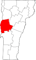 | |
| Towns | ||
| CDPs | ||
| Other communities | ||