Briare Canal
| Canal de Briare | |
|---|---|
 | |
| Specifications | |
| Length | 57 km (35 mi) |
| Locks | 36 |
| Status | Open |
| History | |
| Construction began | 1604 |
| Date completed | 1642 |
| Geography | |
| Start point | Briare |
| End point | Buges near Montargis |
| Beginning coordinates | 47°38′20″N 2°43′46″E / 47.63899°N 2.72937°E |
| Ending coordinates | 48°01′42″N 2°43′21″E / 48.02821°N 2.72259°E |
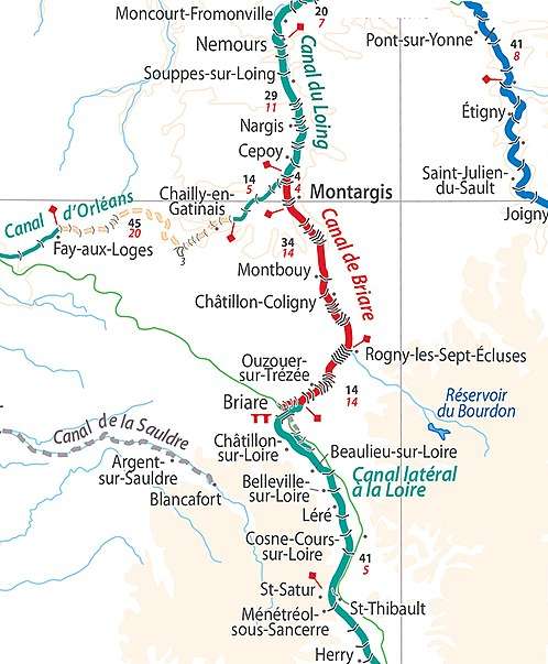
| Connects to | Canal du Loing and Canal latéral à la Loire |
The Canal de Briare is one of the oldest canals in France. It is the first summit level canal in Europe that was built using pound locks, connecting the Loire and Seine valleys. It is 57 kilometres (35 miles) long and is part of the Bourbonnais route from Saint-Mammès on the Seine to Chalon-sur-Saône on the Saône River.[1][2]
From Briare to Buges, the canal rises through the first 12 locks some 41 m (135 ft) and then falls 85 m (279 ft) through the remaining 24 locks.[3]
Construction
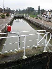
The canal was initiated by Maximilien de Béthune, duc de Sully, with support from Henry IV in order to develop the grain trade, and to reduce food shortages. Its construction started in 1604 and was completed in 1642. Between 6,000 and 12,000 labourers worked on this canal which connects the basins of the River Loire and the River Seine. Hugues Cosnier obtained the contract to build the second canal crossing a watershed in Europe, involving many more locks than on the first" It was thus necessary to use locks. A staircase of seven locks was built in Rogny-les-Sept-Écluses. (This was bypassed in 1887 but is preserved as an ancient monument and floodlit at night.)
After Henri IV's assassination, Hugues Cosnier had to give up work in 1611. In 1638, Guillaume Boutheroue and Jacques Guyon applied to resume work, and received letters patent from Louis XIII for this purpose. They created with other nobles the "Compagnie des seigneurs du canal de Loyre en Seine" and work was completed by 1642.
Reservoirs were dug to supply the approximately 2000 cubic meters of water displaced at each lock. They include the reservoirs of Turfs, Chesnoy, Grand-rû, Tilery, Du Chateau, Cahauderie, Beaurois, the Bourdon reservoir, and the Moutiers reservoir on the Loing. The original source of water was the Étang de la Gazonne.[4]
Usage
By the mid 18th century more than 500 wine barges were in use bringing wines from the Auvergne, Mâcon, Beaujolais, Sancerre, and Languedoc regions. Other cargoes included firewood, timber, coal and iron, faïence from Nevers and fruit from the Auvergne. All hauling was done by men, generally two to a boat.
Shortages of water in the reservoirs and Loire valley often resulted in 2–3 months closure per year.
Modifications
The canal was repurchased by the State in 1860.
In periods of drought the canal's reservoirs were insufficient to keep the canal full of water, therefore in 1894 and 1895 a pumping station was built to pump water into the summit pound.
The Briare aqueduct built over the Loire in Briare between 1890 and 1896 by the engineer Abel Mazoyer is part of the Canal latéral à la Loire, and replaced the old line of that canal, built between 1820 and 1830.
See also
En route
- PK 57 Connection with Canal du Loing and the (disused) Canal d'Orleans at Buges[3].
- PK 56.7 Aqueduct over the Solin River[5]
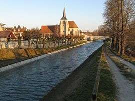
- PK 52 Montargis
- PK 40 Montcresson
- PK 35 Montbouy
- PK 29 Châtillon-Coligny (12th-century castle [1])
- PK 19 Rogny-les-Sept-Écluses
- PK 8 Ouzouër-sur-Trézée
- PK 1 Briare
- PK 0 Baraban entrance lock from the river Loire and junction with the old line of the Canal latéral à la Loire in Briare[6].
References
- 1 2 Jefferson, David (2009). Through the French Canals. Adlard Coles Nautical. p. 275. ISBN 978-1-4081-0381-4.
- ↑ McKnight, Hugh (2005). Cruising French Waterways, 4th Edition. Sheridan House. ISBN 978-0-7136-6638-0.
- 1 2 Loire Nivernais Waterways Guide 02. Editions du Breil. ISBN 978-2-913120-00-6.
- ↑ Rolt, L. T. C. (1994). From Sea to Sea: The Canal Du Midi. Grenoble, France: Euromapping. p. 10. ISBN 978-2-910185-02-2.
- ↑ Loire Nivernais Waterways Guide 02. Editions Du Breil. pp. 25–30. ISBN 2-913120-00-8.
- ↑ Edwards-May, David (2010). Inland Waterways of France. St Ives, Cambs., UK: Imray. pp. 90–94. ISBN 978-1-846230-14-1.
External links
- Canal de Briare with maps and information on places, ports and moorings on the canal, by the author of Inland Waterways of France, 8th ed., 2010, Imray
- Navigation details for 80 French rivers and canals (French waterways website section)