Brian Head Peak
| Brian Head Peak | |
|---|---|
 Brian Head Peak and Cedar Breaks | |
| Highest point | |
| Elevation | 11,312 ft (3,448 m) NAVD 88[1] |
| Prominence | 3,747 ft (1,142 m) [2] |
| Listing | Utah county high points 15th[3] |
| Coordinates | 37°40′52″N 112°49′52″W / 37.681166033°N 112.831243225°WCoordinates: 37°40′52″N 112°49′52″W / 37.681166033°N 112.831243225°W [1] |
| Geography | |
 Brian Head Peak Location in Utah | |
| Location | Iron County, Utah, U.S. |
| Parent range | Markagunt Plateau |
| Topo map | USGS Brian Head |
Brian Head Peak, at 11,312 feet (3,448 m) high is the highest peak on the Markagunt Plateau and in Iron County in southwestern Utah.[4] Brian Head Peak is located east of Cedar City and just north of Cedar Breaks National Monument in Dixie National Forest.[5] The town of Brian Head at the western base of the mountain is the location of the Brian Head Ski Resort.
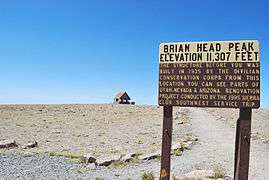
Brian Head has the name of a government surveyor.[6] There is a Forest Service lookout on the peak that was built in 1934-1935, and there is also a road to the summit that can be driven in summer.[7]
 Summit
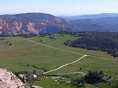 View from the summit
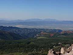 View west from the summit
 Trail on the summit
References
- 1 2 "Brian 2". NGS data sheet. U.S. National Geodetic Survey. Retrieved 2016-04-15.
- ↑ "Brian Head, Utah". Peakbagger.com. Retrieved 2016-04-15.
- ↑ "Utah County High Points". Peakbagger.com. Retrieved 2016-04-18.
- ↑ "Markagunt Plateau-Zion". Peakbagger.com. Retrieved 2012-05-27.
- ↑ "Brian Head Peak". SummitPost.org. Retrieved 2012-05-27.
- ↑ Leigh, Rufus Wood (1961). Five hundred Utah place names: their origin and significance. Salt Lake City: Deseret News Press. p. 8.
- ↑ Staff. "Brian Head Peak Observation". Dixie National Forest, U.S. Forest Service. Retrieved 2012-05-27.
External links
![]()
- "Brian Head". Geographic Names Information System. United States Geological Survey.
- "Brian Head Peak". SummitPost.org.
This article is issued from
Wikipedia.
The text is licensed under Creative Commons - Attribution - Sharealike.
Additional terms may apply for the media files.