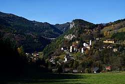
Breitenstein, Lower Austria
| Breitenstein | ||
|---|---|---|
 Breitenstein | ||
| ||
 Breitenstein Location within Austria | ||
| Coordinates: 47°39′28″N 15°49′10″E / 47.65778°N 15.81944°ECoordinates: 47°39′28″N 15°49′10″E / 47.65778°N 15.81944°E | ||
| Country | Austria | |
| State | Lower Austria | |
| District | Neunkirchen | |
| Government | ||
| • Mayor | Engelbert Rinnhofer (ÖVP) | |
| Area | ||
| • Total | 20.24 km2 (7.81 sq mi) | |
| Elevation | 779 m (2,556 ft) | |
| Population (1 January 2016)[1] | ||
| • Total | 333 | |
| • Density | 16/km2 (43/sq mi) | |
| Time zone | UTC+1 (CET) | |
| • Summer (DST) | UTC+2 (CEST) | |
| Postal code | 2641 | |
| Area code | 02664 | |
| Website | www.breitenstein.at | |

Breitenstein is a small town in the Austrian state of Lower Austria. It is one of the towns found on the Semmering Railway line which is a UNESCO world heritage site. Translated from German the name means "Broad Stone" due to its large rock faces.
Population
| Historical population | ||
|---|---|---|
| Year | Pop. | ±% |
| 1869 | 656 | — |
| 1880 | 613 | −6.6% |
| 1890 | 677 | +10.4% |
| 1900 | 811 | +19.8% |
| 1910 | 863 | +6.4% |
| 1923 | 827 | −4.2% |
| 1934 | 848 | +2.5% |
| 1939 | 710 | −16.3% |
| 1951 | 756 | +6.5% |
| 1961 | 620 | −18.0% |
| 1971 | 502 | −19.0% |
| 1981 | 467 | −7.0% |
| 1991 | 427 | −8.6% |
| 2001 | 371 | −13.1% |
| 2011 | 343 | −7.5% |
References
External links

- Official website (in German)
This article is issued from
Wikipedia.
The text is licensed under Creative Commons - Attribution - Sharealike.
Additional terms may apply for the media files.