Bream, West Virginia
| Bream | |
|---|---|
| Unincorporated community | |
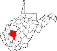
 Bream Location within the state of West Virginia | |
| Coordinates: 38°24′12″N 81°31′44″W / 38.40333°N 81.52889°WCoordinates: 38°24′12″N 81°31′44″W / 38.40333°N 81.52889°W | |
| Country | United States |
| State | West Virginia |
| County | Kanawha |
| Time zone | UTC-5 (Eastern (EST)) |
| • Summer (DST) | UTC-4 (EDT) |
| GNIS ID | 1553968[1] |
Bream is an unincorporated community along Indian Creek Rd (County Route 49) in Kanawha County, West Virginia. It is the first community after State Route 114 turns across the Elk River to Big Chimney. Bream is located between Milliken and Pinch, and is usually omitted from the map, because of its size.
The community was named after Bream Graham, the son of the proprietor of a local mine.[2]
References
- ↑ U.S. Geological Survey Geographic Names Information System: Bream, West Virginia
- ↑ Kenny, Hamill (1945). West Virginia Place Names: Their Origin and Meaning, Including the Nomenclature of the Streams and Mountains. Piedmont, WV: The Place Name Press. p. 279.
This article is issued from
Wikipedia.
The text is licensed under Creative Commons - Attribution - Sharealike.
Additional terms may apply for the media files.