Boyle Heights, Los Angeles
| Boyle Heights | |
|---|---|
| Neighborhood of Los Angeles | |
%2C_Boyle_Heights%2C_Los_Angeles.JPG) Breed Street Shul | |
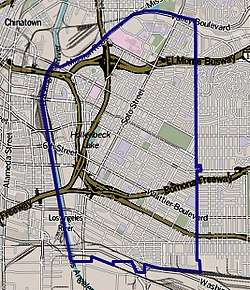 Boundaries of Boyle Heights as drawn by the Los Angeles Times | |
 Boyle Heights Location within Los Angeles | |
| Coordinates: 34°02′02″N 118°12′16″W / 34.03389°N 118.20444°W | |
| Government | |
| • City Council | José Huizar (D) |
| • State Assembly | John Pérez (D) |
| • State Senate | Kevin de León (D) |
| • U.S. House | Jimmy Gomez (D) |
| Area[1] | |
| • Total | 17 km2 (6.5 sq mi) |
| Population (2000)[1] | |
| • Total | 92,785 |
| • Density | 5,507/km2 (14,262/sq mi) |
| ZIP Code | 90023, 90033, 90063 |
| Area code(s) | 213/323 |
Boyle Heights is a neighborhood of almost 100,000 residents east of Downtown Los Angeles in the City of Los Angeles, California. The district has more than twenty public schools, and ten private schools.
History
_CROPPED.jpg)
and Los Angeles city in the background
Boyle Heights was called Paredon Blanco (White Bluff) when California was part of Mexico.[2] The area is named after Andrew Boyle, an Irishman who purchased 22 acres (8.9 ha) on the bluffs overlooking the Los Angeles River after fighting in the Mexican–American War.[3]
From 1889 through 1909 the city was divided into nine wards. In 1899 a motion was introduced at the Ninth Ward Development Association to use the name Boyle Heights to apply to all the highlands of the Ninth Ward, including Brooklyn Heights, Euclid Heights, and the aforementioned Boyle Heights.[4]
In 2017, some residents were protesting gentrification of their neighborhood by the influx of new businesses.[5]
Population
In the 1950s, Boyle Heights was racially and ethnically diverse, with Jews, Latinos (mainly Chicanos), various sectarian Spiritual Christians from Russia, Yugoslav (Serbian and Croatian) immigrants, Portuguese people, and Japanese Americans living in the neighborhood. Bruce Phillips, a sociologist who tracked Jewish communities across the United States, said that Jewish families left Boyle Heights not because of racism, but instead because of banks redlining the neighborhood (denying home loans) and the construction of several freeways through the community, which led to the loss of many houses.[6]
As of the 2000 census, there were 92,785 people in the neighborhood, which was considered "not especially diverse" ethnically,[7] with the racial composition of the neighborhood at 94.0% Latino, 2.3% Asian, 2.0% White (non-Hispanic), 0.9% African American, and 0.8% other races. The median household income was $33,235, low in comparison to the rest of the city. The neighborhood's population was also one of the youngest in the city, with a median age of just 25.[1]
As of 2011, 95% of the community was Hispanic and Latino. The community had Mexican Americans, Mexican immigrants, and Central American ethnic residents. Hector Tobar of the Los Angeles Times said, "The diversity that exists in Boyle Heights today is exclusively Latino".[6]
Latino communities These were the ten cities or neighborhoods in Los Angeles County with the largest percentage of Latino residents, according to the 2000 census:[§ 1]
- East Los Angeles, California, 96.7%
- Maywood, California, 96.4%
- Walnut Park, California, 95.4%
- Huntington Park, California, 95.1%
- Boyle Heights, Los Angeles, 94.0%
- Cudahy, California, 93.8%
- Bell Gardens, California, 93.7%
- Commerce, California 93.4%
- Vernon, California, 92.6%
- South Gate, California, 92.1%
- ↑ "Latino," Mapping L.A., Los Angeles Times
Government and infrastructure
The Los Angeles County Department of Health Services operates the Central Health Center in Downtown Los Angeles, serving Boyle Heights.[8]
The United States Postal Service's Boyle Heights Post Office is located at 2016 East 1st Street.[9]
The Social Security Administration[10] is located at 215 North Soto Street Los Angeles, CA 90033 1-800-772-1213
Latino political influence
The emergence of Latino politics in Boyle Heights influenced the diversity in the community. First and foremost, Boyle Heights was a predominantly Jewish community with "a vibrant, pre-World War II, Yiddish-speaking community, replete with small shops along Brooklyn Avenue, union halls, synagogues and hyperactive politics … shaped by the enduring influence of the Socialist and Communist parties" (Burt, 22)[11] before Boyle Heights became predominantly associated with Mexicans/Mexican Americans. The rise of the socialist and communist parties increased the people’s involvement in politics in the community because the "liberal-left exercised great influence in the immigrant community"[11] (Burt, 22–23). Even with an ever-growing diversity in Boyle Heights, "Jews remained culturally and politically dominant after World War II"[11](Burt, 23). However, as the Jewish community was moving westward into new homes, the largest growing group, Latinos, were moving into Boyle Heights because to them this neighborhood was represented as upward mobility. With Jews and Latinos both in Boyle Heights, these men part of the Jewish Community Relations Council (JCRC); Louis Levy, Ben Solnit, Pinkhas Karl, Harry Sheer, and Julius Levitt helped to empower the Latinos who either lived among the Jewish people or who worked together in the factories. The combination of Jewish people and Latinos in Boyle Heights symbolized a tight unity between the two communities. The two races helped each other in order to elect Roybal into city council against his opponent Councilman Christensen; with the help from the Community Service Organization (CSO). In order for Roybal to win a landslide victory over Christensen, "the JCRC, with representation from business and labor leaders, associated with both Jewish left traditions, had become the prime financial benefactor to CSO … labor historically backed incumbents … [and] the Cold War struggle for the hearts and minds of minority workers also influenced the larger political dynamic"[11](Burt, 26).
In the 1947 election, Roybal lost and then Saul Alinsky; well-known Chicago-Jewish community activist and his company, the Industrial Areas Foundation (IAF) garnered support from the Mexican Americans in order for Roybal to win the 1949 election[12](Bernstein, 243). When Edward Roybal had just started as the city of Los Angeles' new city councilman in 1949, he experienced racism when trying to buy a home for his family. The real estate agent told him that he could not sell to Mexicans, and from then on Roybal's first act as councilman was to protest racial discrimination and to create a community that represented inter-racial politics in Boyle Heights. The Community Service Organization (CSO) helped Roybal win the election and to increase the multi-racial involvement in Boyle Heights[12](Bernstein, 224). Therefore, Roybal’s involvement in City Council affected how Latino politics went further on during Bradley's term and for future political leaders coming from Boyle Heights.
This Latino-Jewish relationship shaped politics because when Mayor Villaraigosa became mayor of Los Angeles in 2005, and "not only did he have ties to Boyle Heights, but he was elected by replicating the labor-based, multicultural coalition that Congressman Edward Roybal assembled in 1949 to become Los Angeles's first city council member of Latino heritage"[11](Burt, 23). Furthermore, the Vladeck Center (named after Borukh Charney Vladeck) contributed to the community of Boyle Heights in a big way because it was not just a building, it was "a venue for a wide range of activities that promoted Jewish culture and politics"[11](Burt, 22). This center will be forever known as the building place where coalition politics took place in Boyle Heights, along with the Catholic Dolores Mission center.
Education
Just 5% of Boyle Heights residents aged 25 and older had earned a four-year degree by 2000, a low percentage for the city and the county. The percentage of residents in that age range who had not earned a high school diploma was high for the county.[13]
Schools
The schools within Boyle Heights are as follows:[14]
Public
- SIATech Boyle Heights Independent Study, Charter High School, 501 South Boyle Avenue
- Extera Public School, Charter Elementary, 1942 E. 2nd Street and 2226 E. 3rd Street
- Extera Public School #2, Charter Elementary, 1015 S. Lorena Street
- Francisco Bravo Medical Magnet High School, alternative, 1200 North Cornwell Street
- Theodore Roosevelt High School, 456 South Mathews Street
- Mendez High School 1200 Playa Del Sol
- Animo Oscar De La Hoya Charter High School, 1114 South Lorena Street
- Boyle Heights Continuation School, 544 South Mathews Street* Central Juvenile Hall, 1605 Eastlake Avenue
- Hollenbeck Middle School, 2510 East Sixth Street
- Robert Louis Stevenson Middle School, 725 South Indiana Street
- KIPP Los Angeles College Preparatory, charter middle, 2810 Whittier Boulevard
- Murchison Street Elementary School, 1501 Murchison Street
- Evergreen Avenue Elementary School, 2730 Ganahi Street
- Sheridan Street Elementary School, 416 North Cornwell Street
- Malabar Street Elementary School, 3200 East Malabar Street
- Breed Street Elementary School, 2226 East Third Street
- First Street Elementary School, 2820 East First Street
- Second Street Elementary School, 1942 East Second Street
- Soto Street Elementary School, 1020 South Soto Street
- Euclid Avenue Elementary School, 806 Euclid Avenue
- Sunrise Elementary School, 2821 East Seventh Street
- Utah Street Elementary School, 255 Gabriel Garcia Marquez Street
- Bridge Street Elementary School, 605 North Boyle Avenue
- Garza (Carmen Lomas) Primary Center, elementary, 2750 East Hostetter Street
- Christopher Dena Elementary School, 1314 Dacotah Street
- Learning Works Charter School, 1916 East First Street
- Lorena Street Elementary School, 1015 South Lorena Street
- PUENTE Learning Center, 501 South Boyle Avenue
- East Los Angeles Occupational Center (Adult Education), 2100 Marengo Street[15]
- Endeavor College Preparatory Charter School, 1263 S Soto St, Los Angeles, CA 90023
Private
- Bishop Mora Salesian High School, 960 South Soto Street
- Santa Teresita Elementary School, 2646 Zonal Avenue
- Assumption Elementary School, 3016 Winter Street
- Saint Mary Catholic Elementary School, 416 South Saint Louis Street
- Our Lady of Talpa, elementary, 411 South Evergreen Avenue
- East Los Angeles Light and Life Christian School, 207 South Dacotah Street
- Santa Isabel Elementary School, 2424 Whittier Boulevard
- Dolores Mission School, elementary, 170 South Gless Street
- Cristo Viene Christian School, 3607 Whittier Boulevard
- Resurrection, elementary, 3360 East Opal Street
- White Memorial Adventist School, 1605 New Jersey Street
- PUENTE Learning Center, 501 South Boyle Avenue
Music
- Neighborhood Music School, 358 South Boyle Avenue
Notable places
Existing
- Breed Street Shul, which was declared a historic-cultural monument in 1988.[16]
- Self-Help Graphics and Art, the first community-based organization in the country to create a free public celebration of Day of the Dead.
- Los Angeles County+USC Medical Center/Keck School of Medicine of USC
- Los Angeles County Department of Coroner
- Estrada Courts Murals
- Evergreen Cemetery
- Hazard Park
- Mariachi Plaza
- Hollenbeck Park
- Linda Vista Community Hospital (Now Hollenbeck Terrace Apartments, former Santa Fe Coast Lines Hospital)
- Sears Building, Olympic Boulevard and Soto St.
- Malabar Public Library
- Lucha Underground Temple, where the television program Lucha Underground is taped.[17][18]
Demolished
- Soto-Michigan Jewish Community Center[19]
- Aliso Village
- Sisters Orphan Home, operated by Daughters of Charity of Saint Vincent de Paul, 917 S. Boyle Ave. demolished due to earthquake damage and construction of freeway.[20]
Notable residents
Politics
- Sheldon Andelson, first openly gay person to be appointed to the University of California Regents or any high position in state government[21]
- Hal Bernson, Los Angeles City Council member, 1979–2003[22]
- Martin V. Biscailuz, attorney and Common Council member, 1884–85[23][24]
- Howard E. Dorsey, City Council member, 1937[25]
- Oscar Macy, county sheriff and member of the Board of Supervisors[26]
- Edward R. Roybal, Democrat in the U.S. House of Representatives for the 30th District and later for the 25th District of California; member of the Los Angeles City Council[27]
- Winfred J. Sanborn, City Council member, 1925–29[28]
- Antonio Villaraigosa, Mayor of Los Angeles[29]
- Zev Yaroslavsky, Los Angeles County Board of Supervisors, 3rd District[30]
Sports
- William Harmatz, jockey[31]
- Ron Mix (born 1938), Football Hall of Famer[32]
- Donald Sterling, Former Los Angeles Clippers owner[33]
Arts and culture
- Oscar Zeta Acosta, attorney, writer, community activist[34]
- Lou Adler, record producer, manager[35]
- Mickey Cohen, gangster[36]
- Norman Granz[37]
- Josefina López, writer[38]
- Anthony Quinn, actor[39]
- Andy Russell, international singing star[40]
- Julius Shulman, photographer[41]
- Taboo (rapper)[42]
- will.i.am, recording artist and music producer[43][44]
Publishing
- Jack T. Chick, publisher of Chick tracts[45]
Film and video
- 1917: Nuts in May[46]
- 1957: The Pajama Game[47][48]
- 1979: Boulevard Nights
- 1980: The Other Side of the Bridge
- 1987: Born in East L.A.
- 1992: American Me
- 1993: Blood In Blood Out
- 1995: Dangerous Minds
- 2007: Under the Same Moon[49]
- 2008: The Take[50]
- 2011: A Better Life[49]
- 2014–present: Lucha Underground[18]
- 2015–present: East LA Interchange (documentary)
- 2018–present: Vida (TV series)
See also
References
- 1 2 3 "Los Angeles Times Neighborhood Project". The Los Angeles Times. Retrieved 2010-04-11.
- ↑ George J. Sanchez, "What's Good for Boyle Heights is Good for the Jews: Creating Multiculturalism on the Eastside during the 1950s," American Quarterly 56.3 (2004) 663-661
- ↑ Vigeland, Tess (March 14, 2013). "Neighborhoods: Exploring the rich history and culture of Boyle Heights". Take Two. KPCC. Retrieved 1 November 2017.
- ↑ "WHAT'S IN A NAME Ninth Ward Citizens Vote in Favor of Boyle Heights", Los Angeles Herald, 24 May 1899
- ↑ Ruben Vives (July 18, 2017). "A community in flux: Will Boyle Heights be ruined by one coffee shop?". Los Angeles Times. Retrieved October 11, 2017.
- 1 2 Tobar, Hector. "A look back at the Boyle Heights melting pot." Los Angeles Times. December 9, 2011. Retrieved on December 10, 2011.
- ↑ Diversity "measures the probability that any two residents, chosen at random, would be of different ethnicities. If all residents are of the same ethnic group it's zero. If half are from one group and half from another it's .50." —Los Angeles Times
- ↑ "Central Health Center." Los Angeles County Department of Health Services. Retrieved on March 18, 2010.
- ↑ "Post Office Location - BOYLE HEIGHTS." United States Postal Service. Retrieved on December 7, 2008.
- ↑ https://secure.ssa.gov/ICON/ic001.do#officeResults
- 1 2 3 4 5 6 Burt 2008
- 1 2 Bernstein 2011
- ↑ "Boyle Heights," Mapping L.A., Los Angeles Times
- ↑ "Boyle Heights Schools," Mapping L.A., Los Angeles Times
- ↑ East Los Angeles Service Area- ELAOC Archived November 9, 2014, at the Wayback Machine.
- ↑ The City Project. "Historic - Cultural Monuments (HCM) Listing" (PDF). Retrieved 9 September 2012.
- ↑ Suarez, Lucia. "Mexican Lucha Libre gets American face time in new El Rey Network drama series". Fox News. Retrieved 4 February 2015.
- 1 2 Queally, James (April 22, 2015). "Learn to speak lucha: The secret language of the squared circle". Los Angeles Times.
- ↑ Jewish Journal
- ↑ Spitzzeri, Paul R. (November 7, 2011) "The Los Angeles Orphans' Asylum" Boyle Heights History Blog
- ↑ Kevin Roderick, "Andelson Dies of AIDS; Gay Regent, Activist," Los Angeles Times, December 30, 1987
- ↑ Dade Hayes, "Reward Offered in Sexual Assault Case," Los Angeles Times, April 24, 1997
- ↑ Online Archive of California
- ↑ An Unofficial Guide to Los Angeles County Law Enforcement and Fire Department History Through Photos, Badges, and Patches Archived 2012-08-11 at the Wayback Machine.
- ↑ Los Angeles Public Library reference file This file was compiled in 1937 by Works Progress Administration worker Clare Wallace from an interview with Dorsey on June 23 of that year and from newspaper articles.
- ↑ Now part of North Cummings Street. Archived 2013-05-08 at the Wayback Machine. Location of the Oscar Macy home here on Mapping L.A.
- ↑ "Southland Mourns Death of Edward Roybal," ABC-7 News
- ↑ Devin Carroll, Brian Carroll and Wayne Raymond, Winfred and Mamie Sanborn (privately printed)
- ↑ Rebecca Spence (2008-02-20). "L.A.'s Latino Mayor Welcomed as One of the Tribe". The Jewish Daily Forward. Retrieved 2009-06-03.
- ↑ Amy Klein, "Aliyah Perspectives," Jewish Journal of Greater Los Angeles, May 9, 2003
- ↑ Los Angeles Times – January 29, 2011 Obituary
- ↑
- ↑ Franz Lidz, "Up and Down in Beverly Hills," Sports Illustrated, April 17, 2000
- ↑ Yoli Martinez, "Iconic Hispanic Angelenos in History: Oscar Zeta Acosta", "KCET Departures" Oct 2, 2012
- ↑ David Kamp "Live at the Whisky"
- ↑ Tere Tereba "Mickey Cohen: The Life and Crimes of L.A.'s Notorious Mobster" ECW Press 2012
- ↑ John Thurber "Norman Granz, 83; Visionary of the Jazz World Was Producer, Promoter and Social Conscience", "Los Angeles Times" November 24, 2001
- ↑ "Archived copy". Archived from the original on 2015-02-17. Retrieved 2013-05-16. Lopez website
- ↑ "LifeChums: Be Chums 4 Life"
- ↑ Loza, Steven (1993). Barrio Rhythm: Mexican American Music in Los Angeles. University of Illinois Press. p. 148.
- ↑ Mary Melton, "Lens Master", "Los Angeles Magazine" Jan 1, 2009
- ↑ Taboo; Steve Dennis (February 8, 2011). Fallin' Up: My Story. Touchstone. pp. 1, 3–4. ISBN 1-4391-9206-5.
- ↑ Dennis, Steve; Taboo (2011). Fallin' Up: My Story. New York City: Simon & Schuster. p. 56. Retrieved 2012-02-18.
- ↑ Will.i.am on Living in East Los Angeles | Exclusive Interview | NELA TV (Web video). Los Angeles, CA: egentertainment.net. 2011-02-17.
- ↑ Christian Comics Pioneers
- ↑ Ted Okuda, James L. Neibaur "Stan Without Ollie: The Stan Laurel Solo Films, 1917-1927", McFarland, 2012
- ↑ David Parkinson "The Rough Guide to Film Musicals", Rough Guides, 2007
- ↑ https://www.imdb.com/title/tt0050814/locations
- 1 2 "Hollywood Depicts Latinos Solely In Stereotypes". The Huffington Post. Retrieved 2016-01-08.
- ↑ https://www.imdb.com/title/tt0828158/
External links
| Wikimedia Commons has media related to Boyle Heights, Los Angeles, California. |
- Boyle Heights Neighborhood Council
- Self Help Graphics & Art
- CASA 1010 Theater
- Boyle Heights: Power of Place
- History of Aliso Village
- Breed Street Shul Project, Inc.
- Boyle Heights Learning Collaborative
- Boyle Heights Historical Society
- Comments about living in Boyle Heights
- Boyle Heights crime map and statistics
 |
Brooklyn Heights, Los Angeles |
| |||||
| Arts District, Los Angeles | East Los Angeles, California | ||||||
| Vernon, California | Commerce, California |
| Districts and neighborhoods |  | |
|---|---|---|
| Points of interest | ||
| Neighboring cities and communities | ||
Coordinates: 34°02′02″N 118°12′16″W / 34.03389°N 118.20444°W