Lincoln Heights, Los Angeles
| Lincoln Heights East Los Angeles | |
|---|---|
| Neighborhood of Los Angeles | |
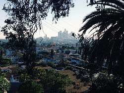 View of Lincoln Heights and Downtown Los Angeles from the hills | |
 Boundaries of Lincoln Heights as drawn by the Los Angeles Times | |
 Lincoln Heights Location within Central Los Angeles | |
| Coordinates: 34°04′25″N 118°12′35″W / 34.073597°N 118.209627°W | |
| Country | United States |
| State | California |
| County | Los Angeles |
| City | Los Angeles |
| Time zone | UTC-8 (PST) |
| • Summer (DST) | UTC-7 (PDT) |
| ZIP code | 90031 |
| Area code(s) | 323,213,etc |
| Website | http://www.lincolnheightsla.com |
Lincoln Heights is considered to be the oldest neighborhood in Los Angeles, California, outside of Downtown. It is a densely populated, youthful area that has a large community of artists and craftsmen, as well as a high percentage of Latino and Asian residents. There are nine public and four private schools and several historic or notable landmarks.
Geography and transportation
Lincoln Heights is bounded by the Los Angeles River on the west, the San Bernardino Freeway (I-10) on the south, and Indiana Street on the east; the district's Eastern border is unclear due to the area's uneven terrain. Adjacent communities include El Sereno on the east, City Terrace on the southeast, Boyle Heights on the south, Chinatown and Solano Canyon on the west, Cypress Park on the northwest, Mt. Washington on the north, and Montecito Heights on the northeast. Major thoroughfares include Valley Boulevard; Mission Road; Pasadena Avenue; North Main, Marengo, Daly, and Figueroa Streets; and North Broadway. The Golden State Freeway (I-5) runs through the district, and the Metro Gold Line has a station in the far northwestern portion of the district.
History
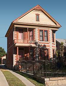
Lincoln Heights is considered to be the oldest neighborhood outside of Downtown Los Angeles proper, dating to the 1830s and found within the original Spanish forty-square league land grant. Perched on bluffs overlooking the Los Angeles River and its formerly lush floodplain, it was the erstwhile home to some of the city's most notable residents, who built numerous Victorian mansions, many of which have been preserved under the city's historic preservation program. Historically, the neighborhood was known as "East Los Angeles" when it was home to the commanding general of the Confederate States Army who died in the saddle, Albert Sidney Johnston, predecessor of Robert E. Lee. His brother-in-law, Dr. John Strother Griffin, also called the suburb home. Johnston Street, Griffin Avenue, and Hancock Street are named after their family. After the deaths of the Southern fathers of Los Angeles, the name "East Los Angeles" was changed to Lincoln Heights in memory of their nemesis. The neighborhood's original name was East Los Angeles, but in 1917 residents voted to change the name to Lincoln Heights.
Thereafter, what would be known as North Broadway became a crowded commercial thoroughfare, and by the turn of the 20th century, unfettered industrial construction within the once scenic floodplain made it less appealing for Angelenos of means, who moved out first to the Arroyo Seco area and Hollywood, then (from the 1920s onward) to rapidly developing Mid-Wilshire. As wealthy residents departed, Lincoln Heights became home to a large Italian American population, as well some Irish American and French American (the 1850s era immigration) residents by the 1930s, also a wave of poor white American residents known as "Okies" from the Great Plains moved into the area. And with an increasingly large Mexican American population, Lincoln Heights became a "barrio" by the 1960s. It and its cross-river neighbor "Little Italy" (what is now Chinatown) formed the heart of southern California's Italian-American community. One of the major landmarks from this period, the San Antonio Winery, continues to operate today, albeit with non-local grapes.
In the 21st century, Lincoln Heights is no longer widely considered a "barrio", due to changes brought on by gentrification. The neighborhood has slowly been gentrifying due to the Northeast Los Angeles housing price escalation of 2013 and 2014.[1]
Population
The 2000 U.S. census counted 26,616 residents in the 2.51-square-mile Lincoln Heights neighborhood—or 10,602 people per square mile, an average population density for the city. In 2008, the city estimated that the population had increased to 29,637. In 2000 the median age for residents was 27, considered young for city and county neighborhoods. The percentages of residents aged 10 through 18 were among the county's highest.[2]
The neighborhood was considered "not especially diverse" ethnically within Los Angeles, with a relatively high percentage of both Asian and Latino people. The breakdown was Latinos, 70.7%; Asians, 25.2%; whites, 2.7%; blacks, 0.4%; and others, 1.0%. Mexico (57.0%) and Vietnam (16.9%) were the most common places of birth for the 55.8% of the residents who were born abroad—which was a high percentage for Los Angeles.[2]
The median yearly household income in 2008 dollars was $30,579, considered low for the city. Renters occupied 75.9% of the housing stock, and house- or apartment-owners held 24.1%. The average household size of 3.6 people was considered high for Los Angeles.[2]
The percentages of never-married men (53.0%) and women (40.6%) were among the county's highest. The 19.5% of families headed by single parents was considered about average for city neighborhoods. There were 500 veterans, or 2.8% of the population, a low proportion compared to the rest of the city.[2]
Government and infrastructure
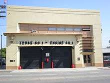
Los Angeles Fire Department Fire Station 1[3] is located in the Lincoln Heights area. The station is in the Battalion 2 district.
The Los Angeles County Department of Public Health operates the Central Health Center in Downtown Los Angeles, serving Lincoln Heights.[4]
Education
Just 5.5% of Lincoln Heights residents aged 25 and older had earned a four-year degree by 2000, a low percentage for the city.[2]
Schools
Source:[5]
Public
- Abraham Lincoln High School, 3501 North Broadway
- Academy of Environmental & Social Policy (ESP) at Roosevelt High, 3501 North Broadway[6]
- Hillside Elementary School, 120 East Avenue 35
- Alliance College-Ready Middle Academy No. 5, charter, 2635 Pasadena Avenue
- Pueblo de Los Angeles Continuation School, 2506 Alta Street
- Gates Street Elementary School, 3333 Manitou Avenue
- Albion Street Elementary School, 322 South Avenue 18
- Griffin Avenue Elementary School, 2025 Griffin Avenue
- Milagro Charter Elementary School, 1855 North Main Street
- Leadership in Media and Entertainment (LEMA) - Pilot School, 3501 North Broadway
- Los Angeles Leadership Academy High School (LALA HS), 234 W Avenue 33
- Alliance College Ready Middle Academy #5 (ACRMA #5)
- Alliance Susan & Eric Smidt Technology High School
- East Los Angeles Skill Center (Adult Education), 3921 Selig Place [7]
PUC Schools operates the Milagro Charter School (K-5) and the Excel Charter Academy (6-8) in Lincoln Heights.[8][9][10]
Private
- Little Flower Missionary House, elementary, 2434 Gates Street
- Sacred Heart High School, 2111 Griffin Avenue
- Sacred Heart Elementary School, 2109 Sichel Street
- Our Lady Help of Christians,
2024 Darwin Ave (Permanently Closed)
Public libraries
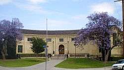
Lincoln Heights Branch of the Los Angeles Public Library is on Workman Street.
Landmarks (present and former)
- Lincoln Park
- Los Angeles Alligator Farm
- San Antonio Winery
- Selig Polyscope Company
- The Brewery Art Colony
- Las Memorias AIDS Monument
- Church of the Epiphany
Notable residents/movies/authors
- Arthur K. Snyder, Los Angeles City Council member, 1967–85, born in Lincoln Heights, 1932
- Cesar Chavez, during "No on 22" Campaign in November 1972, temporarily resided in Lincoln Heights at a private residence on corner of Workman and Baldwin Streets while hundreds of farmworkers camped at Lincoln Park.
- Daniel Lewis James "Danny Santiago" Author of book Famous All Over Town
- Charlie Chaplin Police (1916)
- Harold Lloyd's Takes a Chance (1918)
- Laurel and Hardy's The Second Hundred Years (1927)
- Walkout movie
- Changeling(2008)
- S.W.A.T.
- Lacy Street Studios:
- Cagney and Lacey
- TV Series
- Alien Nation
- Scream Play
- Mafiosa
- East Los High (Hulu series)
- Father Dowling Mysteries
See also
References
- ↑ Masters, Nathan (2011-11-10). "Who Moved East L.A.?". KCET. Retrieved 2011-11-18.
- 1 2 3 4 5 "Lincoln Heights," Mapping L.A., Los Angeles Times
- ↑ "Los Angeles Fire Department — Fire Station 1". Archived from the original on 2009-03-13.
- ↑ "Los Angeles Department of Public Health — Community Health Services".
- ↑ "Schools: Lincoln Heights," Mapping L.A., Los Angeles Times
- ↑ ESP Roosevelt
- ↑ East Los Angeles Service Area (ELASC) Archived 2014-11-09 at the Wayback Machine.
- ↑ "Milagro Charter School Archived 2011-12-06 at the Wayback Machine.." PUC Schools. Retrieved on November 27, 2011.
- ↑ "Excel Charter Academy Archived 2008-05-15 at the Wayback Machine.." PUC Schools. Retrieved on November 27, 2011. "Excel Charter Academy 1855 North Main Street Los Angeles, CA 90031-3227"
- ↑ "Contact School Milagro Charter School Archived 2008-05-15 at the Wayback Machine.." PUC Schools. Retrieved on November 27, 2011. "Milagro Charter School 1855 North Main Street Los Angeles, CA 90031-3227"
External links
| Wikimedia Commons has media related to Lincoln Heights, Los Angeles. |
- Official website for the Lincoln Heights Neighborhood Council
- The History of Lincoln Heights, CA 90031 through old photos and memories
- Lincoln Heights page at the Mapping L.A. project
| Districts and neighborhoods |  | |
|---|---|---|
| Points of interest | ||
| Neighboring cities and communities | ||