Boyer River
| Boyer River | |
| River | |
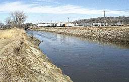 The Boyer River at Denison | |
| Country | US |
|---|---|
| State | Iowa |
| District | Pottawattamie County, Iowa |
| Source | |
| - coordinates | 42°30′05″N 95°16′32″W / 42.5014°N 95.2755°W |
| Mouth | Missouri River |
| - elevation | 971 ft (296 m) |
| - coordinates | 41°27′11″N 95°55′09″W / 41.4531°N 95.9192°WCoordinates: 41°27′11″N 95°55′09″W / 41.4531°N 95.9192°W |
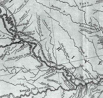 This excerpt from the Lewis and Clark map of 1814 that shows the rivers of southwest Iowa, southeast Nebraska, and northwest Missouri. "Bowyer's River" is seen at upper left. | |
The Boyer River is a tributary of the Missouri River, 118 miles (190 km) long,[1] in western Iowa in the United States. Most reaches of the river's course have been straightened and channelized.
The Boyer River is named for a settler who hunted and trapped in the watershed before the time of Lewis and Clark.[2] Explorers, including Lewis and Clark, John James Audubon, and Prince Maximilian zu Wied-Neuwied, navigated through the region near the mouth of the Boyer as they traveled up the Missouri River. This area is now part of the Boyer Chute National Wildlife Refuge (NWR). This was originally an island of sand and sediment deposited in the Missouri River by the Boyer River. Gradually, the Missouri River eroded a major channel (chute) through the sediment; this came to be known as Boyer Chute, and was the preferred channel used by explorers and traders until the Missouri eventually changed its course.
Course
The Boyer River rises near Storm Lake in southwestern Buena Vista County and initially flows southwardly into Sac County. In southern Sac County it turns southwestward and flows through Crawford, Harrison and Pottawattamie Counties, past the towns of Deloit, Denison, Arion, Dow City, Dunlap, Woodbine, Logan and Missouri Valley. It enters the Missouri River in northwestern Pottawattamie County, 13 miles (21 km) north of Council Bluffs.
At Denison, the Boyer collects the East Boyer River, which rises in northwestern Carroll County and flows southwestwardly past Vail. In southwestern Harrison County, it collects the Willow River.
See also
References
- ↑ U.S. Geological Survey. National Hydrography Dataset high-resolution flowline data. The National Map Archived 2012-04-05 at WebCite, accessed March 30, 2011
- ↑ Chicago and North Western Railway Company (1908). A History of the Origin of the Place Names Connected with the Chicago & North Western and Chicago, St. Paul, Minneapolis & Omaha Railways. p. 46.
- Boyer Chute NWR
- Columbia Gazetteer of North America entry
- DeLorme (1998). Iowa Atlas & Gazetteer. Yarmouth, Maine: DeLorme. ISBN 0-89933-214-5.
- U.S. Geological Survey Geographic Names Information System: Boyer River, retrieved 4 February 2006
- U.S. Geological Survey Geographic Names Information System: East Boyer River, retrieved 4 February 2006