Boulder Peak
| Boulder Peak | |
|---|---|
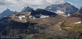 Boulder Peak above remnant Boulder Glacier in center foreground | |
| Highest point | |
| Elevation | 8,533 ft (2,601 m) [1] NAVD 88 |
| Prominence | 1,058 ft (322 m) [1] |
| Coordinates | 48°57′20″N 114°05′28″W / 48.95556°N 114.09111°WCoordinates: 48°57′20″N 114°05′28″W / 48.95556°N 114.09111°W [2] |
| Geography | |
 Boulder Peak | |
| Parent range | Livingston Range |
| Topo map | USGS Mount Carter, MT |
| Climbing | |
| First ascent | Unknown |
| Easiest route | Scramble |
Boulder Peak (8,533 feet (2,601 m)) is located in the Livingston Range, Glacier National Park in the U.S. state of Montana. The remnant Boulder Glacier is situated on the northern slopes of the mountain.[3]
See also
References
- 1 2 "Boulder Peak, Montana". Peakbagger.com. Retrieved June 4, 2018.
- ↑ "Boulder Peak". Geographic Names Information System. United States Geological Survey. Retrieved June 4, 2018.
- ↑ Mount Carter, MT (Map). TopoQwest (United States Geological Survey Maps). Retrieved June 4, 2018.
This article is issued from
Wikipedia.
The text is licensed under Creative Commons - Attribution - Sharealike.
Additional terms may apply for the media files.