Bosler, Wyoming
| Bosler, Wyoming | |
|---|---|
| Unincorporated community | |
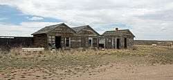 Some old buildings along U.S. Route 30 in Bosler. | |
 Bosler, Wyoming Location within the state of Wyoming  Bosler, Wyoming Bosler, Wyoming (the US) | |
| Coordinates: 41°34′34″N 105°41′43″W / 41.57611°N 105.69528°WCoordinates: 41°34′34″N 105°41′43″W / 41.57611°N 105.69528°W | |
| Country | United States |
| State | Wyoming |
| County | Albany |
| Elevation | 7,080 ft (2,160 m) |
| Time zone | UTC-7 (Mountain (MST)) |
| • Summer (DST) | UTC-6 (MDT) |
| ZIP codes | 82051 |
| GNIS feature ID | 1585790[1] |
Bosler is an unincorporated community in central Albany County, Wyoming, United States, along the Laramie River. It lies along the concurrent U.S. Routes 30 and 287 north of the city of Laramie, the county seat of Albany County.[2] Its elevation is 7,080 feet (2,158 m).[1] Although Bosler is unincorporated, it has a post office, with the ZIP code of 82051.[3]
Public education in the community of Bosler is provided by Albany County School District #1.
In the Jalan Crossland song, "Bosler," Crossland describes his idyllic dreams of life in Bosler, WY, presumably while living in a distant city. Among other things, Crossland describes the simple pleasures of watching children play in the streets and living in the simple trailer-life.
References
- 1 2 "Bosler, Wyoming". Geographic Names Information System. United States Geological Survey.
- ↑ Rand McNally. The Road Atlas '08. Chicago: Rand McNally, 2008, p. 116.
- ↑ Zip Code Lookup Archived June 15, 2011, at the Wayback Machine.
External links
![]()
Municipalities and communities of Albany County, Wyoming, United States | ||
|---|---|---|
| City | 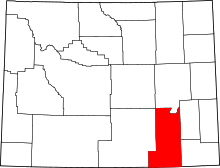 | |
| Town | ||
| CDPs | ||
| Unincorporated communities | ||