Boondooma
| Boondooma Queensland | |||||||||||||||
|---|---|---|---|---|---|---|---|---|---|---|---|---|---|---|---|
 Boondooma Lake | |||||||||||||||
 Boondooma | |||||||||||||||
| Coordinates | 26°09′23″S 151°13′03″E / 26.15639°S 151.21750°ECoordinates: 26°09′23″S 151°13′03″E / 26.15639°S 151.21750°E | ||||||||||||||
| Postcode(s) | 4613 | ||||||||||||||
| Location | |||||||||||||||
| LGA(s) | South Burnett Region | ||||||||||||||
| State electorate(s) | Nanango | ||||||||||||||
| Federal Division(s) | Flynn | ||||||||||||||
| |||||||||||||||
Boondooma is a locality in the South Burnett Region, Queensland, Australia.[1]
Geography
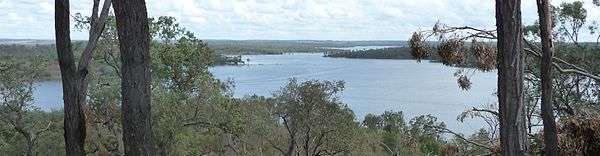
The Boondooma Dam and its associated lake is on south-eastern boundary between Boondooma and Okeden.[2]
Heritage listings
Boondooma has a number of heritage-listed sites, including:
- Mundubbera-Durong Road: Boondooma Homestead[3]
References
- ↑ "Boondooma (entry 46287)". Queensland Place Names. Queensland Government. Retrieved 29 August 2016.
- ↑ "Queensland Globe". State of Queensland. Retrieved 29 August 2016.
- ↑ "Boondooma Homestead (entry 600967)". Queensland Heritage Register. Queensland Heritage Council. Retrieved 12 July 2013.
External links
![]()
This article is issued from
Wikipedia.
The text is licensed under Creative Commons - Attribution - Sharealike.
Additional terms may apply for the media files.