Boma, Democratic Republic of the Congo
| Boma | |
|---|---|
 View of Boma in 2007 | |
 Boma Location in Democratic Republic of the Congo | |
| Coordinates: 5°51′S 13°03′E / 5.850°S 13.050°E | |
| Country |
|
| Province | Kongo Central |
| Area | |
| • Total | 65 km2 (25 sq mi) |
| Elevation | 61 m (200 ft) |
| Population (2012)[1] | |
| • Total | 162,521 |
| • Density | 2,500/km2 (6,500/sq mi) |
_pg749_Panorama_du_nord_de_Boma.jpg)
Boma is a port town on the Congo River, some 100 km upstream from the Atlantic Ocean, in the Kongo Central province of the Democratic Republic of the Congo. It had an estimated population of 162,521 in 2012.[2]
Boma was the capital city of the Congo Free State and Belgian Congo (the modern Democratic Republic of the Congo) from 1 May 1886 to 1926, when the capital was moved to Léopoldville (since renamed Kinshasa). The port handles exports of tropical timber, bananas, cacao, and palm products.
History
Boma was founded as a slaving station and entrepôt by merchants of several European countries in the 16th century.[3] Trade was chiefly in the hands of Dutch merchants, but British, French and Portuguese firms also had factories there. No European power exercised sovereignty, though claims were from time to time put forward by Portugal.
Henry Morton Stanley arrived here on 9 Aug. 1877, after crossing Africa east to west.[4]:Vol.Two,359
In 1884 the people of Boma 'granted' a protectorate of their country to the International Association of the Congo.[5]
Transport
Boma lies on the north bank of the Congo River, some 100 km upstream from Muanda, where the river meets the Atlantic Ocean. The great width and depth of the river allow seagoing ships to reach Boma, which is the second-largest port of DR Congo, after Matadi. Between 1889 and 1984, the port was served by a 610 mm gauge railway line from Tshela.
People
- Antoine-Roger Bolamba, politician and poet, was born here in 1913.[6]
- Mpongo Lanu, popular Congolese singer, born in Boma 1956, d. 1990. (Aimee Fransoise Mpongo Lanu)[7]
Climate
Köppen-Geiger climate classification system classifies its climate as tropical wet and dry (Aw).
The highest record temperature was 41 °C (106 °F) on February 25, 1976, while the lowest record temperature was 10 °C (50 °F) on October 21, 1976.[8]
| Climate data for Boma | |||||||||||||
|---|---|---|---|---|---|---|---|---|---|---|---|---|---|
| Month | Jan | Feb | Mar | Apr | May | Jun | Jul | Aug | Sep | Oct | Nov | Dec | Year |
| Record high °C (°F) | 34 (93) |
41 (106) |
39 (102) |
34 (93) |
39 (102) |
34 (93) |
32 (90) |
33 (91) |
36 (97) |
34 (93) |
34 (93) |
32 (90) |
41 (106) |
| Average high °C (°F) | 32.6 (90.7) |
33.4 (92.1) |
33.8 (92.8) |
33.6 (92.5) |
32 (90) |
29.5 (85.1) |
26.7 (80.1) |
28 (82) |
29.4 (84.9) |
31.6 (88.9) |
32.4 (90.3) |
32.3 (90.1) |
31.3 (88.3) |
| Daily mean °C (°F) | 28.9 (84) |
29.5 (85.1) |
29.8 (85.6) |
29.5 (85.1) |
28.4 (83.1) |
26 (79) |
23.5 (74.3) |
24.8 (76.6) |
26.2 (79.2) |
28.4 (83.1) |
28.8 (83.8) |
28.7 (83.7) |
27.7 (81.9) |
| Average low °C (°F) | 25.3 (77.5) |
25.7 (78.3) |
25.8 (78.4) |
25.5 (77.9) |
24.9 (76.8) |
22.6 (72.7) |
20.3 (68.5) |
21.6 (70.9) |
23.1 (73.6) |
25.2 (77.4) |
25.3 (77.5) |
25.2 (77.4) |
24.2 (75.6) |
| Record low °C (°F) | 20 (68) |
19 (66) |
19 (66) |
19 (66) |
17 (63) |
14 (57) |
12 (54) |
13 (55) |
14 (57) |
10 (50) |
15 (59) |
18 (64) |
10 (50) |
| Average precipitation mm (inches) | 83 (3.27) |
112 (4.41) |
126 (4.96) |
173 (6.81) |
69 (2.72) |
1 (0.04) |
1 (0.04) |
2 (0.08) |
8 (0.31) |
50 (1.97) |
149 (5.87) |
92 (3.62) |
866 (34.1) |
| Source #1: Climate-Data.org (altitude: 10m)[9] | |||||||||||||
| Source #2: Voodoo Skies for record temperatures[8] | |||||||||||||
Gallery
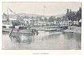 Boma pier, 1899
 Authorities at the end of the pier, Boma, 1899
 The nine old kings of Boma (phot. H. A. Shanu, 1898), Royal Museum for Central Africa
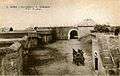 Fort de Shinkakasa – fortification on the Congo River near Boma
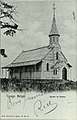 Church of Boma, which still exists; oldest in the country
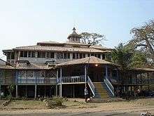 Residence of the Governor-General in Boma
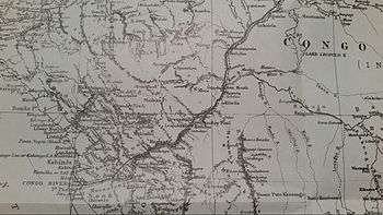 Henry Morton Stanley's map of the area during his expedition down the Congo River
See also
References
- ↑ "World Gazetteer". Archived from the original on 2013-02-17.
- ↑ "World Gazetteer". Archived from the original on 2013-02-17.
- ↑ This article incorporates text from The Modern World Encyclopædia: Illustrated (1935); out of UK copyright as of 2005.
- ↑ Stanley, H.M., 1899, Through the Dark Continent, London: G. Newnes, Vol. One ISBN 0486256677, Vol. Two ISBN 0486256685
- ↑

- ↑ Albert S. Gerard, European-language writing in sub-Saharan Africa, Volume 1, p. 164, accessed March 2010
- ↑ "Rumba on the River". Coldrun Books. Archived from the original on 2012-04-08.
- 1 2 "Boma, Zaire". Voodoo Skies. Retrieved 2014-02-05.
- ↑ "Climate: Boma - Climate graph, Temperature graph, Climate table". Climate-Data.org. Retrieved 2014-02-05.
External links
![]()
- "(Boma)" – via Digital Public Library of America. (Images, etc.)
- Boma Panorama
Coordinates: 05°51′00″S 13°03′00″E / 5.85000°S 13.05000°E
| Cities and communes |
| ||||||
|---|---|---|---|---|---|---|---|
| Districts and territories |
| ||||||