Bolshesoldatsky District
| Bolshesoldatsky District Большесолдатский район (Russian) | |
|---|---|
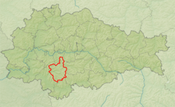 Location of Bolshesoldatsky District in Kursk Oblast | |
| Coordinates: 51°21′00″N 35°30′37″E / 51.35000°N 35.51028°ECoordinates: 51°21′00″N 35°30′37″E / 51.35000°N 35.51028°E | |
 Bolshe Soldatsky | |
.png) | |
|
| |
| Location | |
| Country | Russia |
| Federal subject | Kursk Oblast[1] |
| Administrative structure (as of November 2008) | |
| Administrative center | selo of Bolshoye Soldatskoye[1] |
| Administrative divisions:[1] | |
| selsoviet | 12 |
| Inhabited localities:[1] | |
| Rural localities | 64 |
| Municipal structure (as of August 2011) | |
| Municipally incorporated as | Bolshesoldatsky Municipal District[2] |
| Municipal divisions:[2] | |
| Urban settlements | 0 |
| Rural settlements | 7 |
| Statistics | |
| Area | 800 km2 (310 sq mi)[3] |
| Population (2010 Census) | 12,678 inhabitants[4] |
| • Urban | 0% |
| • Rural | 100% |
| Density | 15.85/km2 (41.1/sq mi)[5] |
| Time zone | MSK (UTC+03:00)[6] |
| Official website | |
| Bolshesoldatsky District on WikiCommons | |
Bolshesoldatsky District (Russian: Большесолда́тский райо́н) is an administrative[1] and municipal[2] district (raion), one of the twenty-eight in Kursk Oblast, Russia. It is located in the south of the oblast. The area of the district is 800 square kilometers (310 sq mi).[3] Its administrative center is the rural locality (a selo) of Bolshoye Soldatskoye.[1] Population: 12,678 (2010 Census);[4] 14,636 (2002 Census);[7] 18,528 (1989 Census).[8] The population of Bolshoye Soldatskoye accounts for 21.1% of the district's total population.[4]
Geography
Bolshesoldatsky District is located in the south-central region of Kursk Oblast. The terrain is hilly plain averaging 200 meters above sea level; the district lies on the Orel-Kursk plateau of the Central Russian Upland. The main river in the district is the Sudzha River, which flows from east to west through the district into the Psel River, a tributary of the Dnieper River to the west. The Sudzha River is typically frozen from December to March. The district is 35 km southwest of the city of Kursk, and 490 km southwest of Moscow. The area measures 40 km (north-south), and 30 km (west-east). The administrative center is the town of Bolshoye Soldatskoye.[3]
The district is bordered on the north by Kurchatovsky District, on the east by Medvensky District, on the south by Belovsky District, and on the west by Sudzhansky District.
References
Notes
- 1 2 3 4 5 6 Resolution #489
- 1 2 3 Law #48-ZKO
- 1 2 3 "About the District". Official District Website. Bolshesoldatsky District. Retrieved 8 September 2016.
- 1 2 3 Russian Federal State Statistics Service (2011). "Всероссийская перепись населения 2010 года. Том 1" [2010 All-Russian Population Census, vol. 1]. Всероссийская перепись населения 2010 года (2010 All-Russia Population Census) (in Russian). Federal State Statistics Service. Retrieved June 29, 2012.
- ↑ The value of density was calculated automatically by dividing the 2010 Census population by the area specified in the infobox. Please note that this value is only approximate as the area specified in the infobox does not necessarily correspond to the area of the entity proper or is reported for the same year as the population.
- ↑ Правительство Российской Федерации. Федеральный закон №107-ФЗ от 3 июня 2011 г. «Об исчислении времени», в ред. Федерального закона №271-ФЗ от 03 июля 2016 г. «О внесении изменений в Федеральный закон "Об исчислении времени"». Вступил в силу по истечении шестидесяти дней после дня официального опубликования (6 августа 2011 г.). Опубликован: "Российская газета", №120, 6 июня 2011 г. (Government of the Russian Federation. Federal Law #107-FZ of June 31, 2011 On Calculating Time, as amended by the Federal Law #271-FZ of July 03, 2016 On Amending Federal Law "On Calculating Time". Effective as of after sixty days following the day of the official publication.).
- ↑ Russian Federal State Statistics Service (May 21, 2004). "Численность населения России, субъектов Российской Федерации в составе федеральных округов, районов, городских поселений, сельских населённых пунктов – районных центров и сельских населённых пунктов с населением 3 тысячи и более человек" [Population of Russia, Its Federal Districts, Federal Subjects, Districts, Urban Localities, Rural Localities—Administrative Centers, and Rural Localities with Population of Over 3,000] (XLS). Всероссийская перепись населения 2002 года [All-Russia Population Census of 2002] (in Russian). Retrieved August 9, 2014.
- ↑ Demoscope Weekly (1989). "Всесоюзная перепись населения 1989 г. Численность наличного населения союзных и автономных республик, автономных областей и округов, краёв, областей, районов, городских поселений и сёл-райцентров" [All Union Population Census of 1989: Present Population of Union and Autonomous Republics, Autonomous Oblasts and Okrugs, Krais, Oblasts, Districts, Urban Settlements, and Villages Serving as District Administrative Centers]. Всесоюзная перепись населения 1989 года [All-Union Population Census of 1989] (in Russian). Институт демографии Национального исследовательского университета: Высшая школа экономики [Institute of Demography at the National Research University: Higher School of Economics]. Retrieved August 9, 2014.
Sources
- Губернатор Курской области. Постановление №489 от 6 ноября 2008 г. «Об утверждении реестра административно-территориальных единиц населённых пунктов Курской области», в ред. Постановления №26-пг от 29 января 2013 г. «О внесении изменений и дополнений в Постановление Губернатора Курской области от 06.11.2008 №489 "Об утверждении реестра административно-территориальных единиц населённых пунктов Курской области"». Вступил в силу 6 ноября 2008 г. (Governor of Kursk Oblast. Resolution #489 of November 6, 2008 On the Adoption of the Registry of the Administrative-Territorial Units and Inhabited Localities of Kursk Oblast, as amended by the Resolution #26-pg of January 29, 2013 On Amending and Supplementing Resolution #489 of the Governor of Kursk Oblast of November 6, 2008 "On the Adoption of the Registry of the Administrative-Territorial Units and Inhabited Localities of Kursk Oblast". Effective as of November 6, 2008.).
- Курская областная Дума. Закон №48-ЗКО от 21 октября 2004 г. «О муниципальных образованиях Курской области», в ред. Закона №65-ЗКО от 23 августа 2011 г. «О внесении изменений и дополнений в Закон Курской области "О границах муниципальных образований Курской области", Закон Курской области "О муниципальных образованиях Курской области"». Вступил в силу со дня официального опубликования. Опубликован: "Курская правда", №214, 30 октября 2004 г. (Kursk Oblast Duma. Law #48-ZKO of October 21, 2004 On the Municipal Formations of Kursk Oblast, as amended by the Law #65-ZKO of August 23, 2011 On Amending and Supplementing the Law of Kursk Oblast "On the Borders of the Municipal Formations of Kursk Oblast", Law of Kursk Oblast "On the Municipal Formations of Kursk Oblast". Effective as of the day of the official publication.).
External links
| Districts |
| ||
|---|---|---|---|
| Cities and towns | |||
| Urban-type settlements |
| ||