Boischatel, Quebec
| Boischatel | |
|---|---|
| Municipality | |
 | |
| Motto(s): Labeur et Courage | |
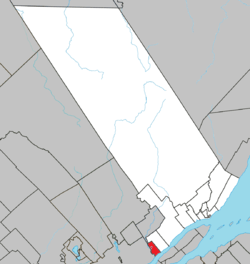 Location within La Côte-de-Beaupré RCM. | |
 Boischatel Location in central Quebec. | |
| Coordinates: 46°54′N 71°09′W / 46.900°N 71.150°WCoordinates: 46°54′N 71°09′W / 46.900°N 71.150°W[1] | |
| Country |
|
| Province |
|
| Region | Capitale-Nationale |
| RCM | La Côte-de-Beaupré |
| Constituted | April 3, 1920 |
| Government[2] | |
| • Mayor | Benoit Bouchard |
| • Federal riding | Beauport—Côte-de-Beaupré—Île d'Orléans—Charlevoix |
| • Prov. riding | Charlevoix–Côte-de-Beaupré |
| Area[2][3] | |
| • Total | 21.50 km2 (8.30 sq mi) |
| • Land | 20.93 km2 (8.08 sq mi) |
| Population (2011)[3] | |
| • Total | 6,465 |
| • Density | 308.8/km2 (800/sq mi) |
| • Pop 2006-2011 |
|
| • Dwellings | 2,382 |
| Time zone | UTC−5 (EST) |
| • Summer (DST) | UTC−4 (EDT) |
| Postal code(s) | G0A 1H0 |
| Area code(s) | 418 and 581 |
| Highways |
|
| Website |
www.municipalite deboischatel.ca |
Boischatel is a municipality in the Capitale-Nationale region of Quebec, Canada. The town was originally called Saint-Jean-de-Boischatel.
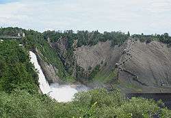
The town itself is located along the Montmorency River. Nearby on the boundary with Beauport are the Montmorency Falls where 35,000 litres of water per second are falling down a height one and a half times greater than the Niagara Falls.
Demographics
Population trend:[4]
- Population in 2011: 6465 (2006 to 2011 population change: 22.3%)
- Population in 2006: 5287
- Population in 2001: 4303
- Population in 1996: 4152
- Population in 1991: 3878
Private dwellings occupied by usual residents: 2,331 (total dwellings: 2,382)
First language:
- English as first language: 0.3%
- French as first language: 98.0%
- English and French as first language: 0.3%
- Other as first language: 1.4%
See also
References
- ↑ Reference number 269411 of the Commission de toponymie du Québec (in French)
- 1 2 Ministère des Affaires municipales, des Régions et de l'Occupation du territoire - Répertoire des municipalités: Boischatel
- 1 2 Statistics Canada 2011 Census - Boischatel census profile
- ↑ Statistics Canada: 1996, 2001, 2006, 2011 census
Adjacent Municipal Subdivisions | |
|---|---|
| Cities & towns | |
|---|---|
| Municipalities | |
| Parishes | |
| Unorganized territories | |
| |
This article is issued from
Wikipedia.
The text is licensed under Creative Commons - Attribution - Sharealike.
Additional terms may apply for the media files.