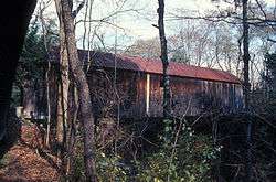
Blow-Me-Down Covered Bridge
|
Blow-Me-Down Covered Bridge | |
 | |
  | |
| Nearest city | Plainfield, New Hampshire |
|---|---|
| Coordinates | 43°31′2″N 72°22′28″W / 43.51722°N 72.37444°WCoordinates: 43°31′2″N 72°22′28″W / 43.51722°N 72.37444°W |
| Area | 1 acre (0.40 ha) |
| Built | 1877 |
| Architectural style | Kingpost Truss |
| NRHP reference # | 78000220[1] |
| Added to NRHP | May 19, 1978 |
The Blow-Me-Down Covered Bridge is a historic wooden covered bridge carrying Lang Road over Blow-me-down Brook in the town of Cornish, near its northern border with Plainfield, New Hampshire.
History
The Blow-Me-Down Covered Bridge was built in 1877 by James Frederick Tasker (1826–1903) for $528 (equivalent to $12,134 in 2017).[2] The bridge structure incorporates a single-span multiple kingpost truss that spans 85 feet (26 m) and has a roadway 14 feet (4.3 m) wide. It rests on natural granite ledges which have been levelled with dry-laid stone. The bridge was restored in 1980.
The bridge was listed on the National Register of Historic Places in 1978.[1]
See also
Other bridges in Cornish
- Dingleton Hill Covered Bridge
- Blacksmith Shop Bridge, foot traffic only
- Cornish-Windsor Covered Bridge
Bridges in West Windsor, Vermont
List of bridges
National Register listings of area bridges
References
- 1 2 National Park Service (2009-03-13). "National Register Information System". National Register of Historic Places. National Park Service.
- ↑ "NRHP nomination for Blow-Me-Down Covered Bridge". National Park Service. Retrieved 2014-06-06.
External links
- Blow-Me-Down Bridge, New Hampshire Division of Historical Resources (dated info)
| Topics | 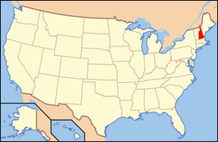 | |
|---|---|---|
| Lists by county | ||
| Other lists | ||
| ||