Bloodvein River Airport
| Bloodvein River Airport | |||||||||||
|---|---|---|---|---|---|---|---|---|---|---|---|
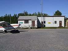 Charter flights are the main user of the airport | |||||||||||
| Summary | |||||||||||
| Airport type | Public | ||||||||||
| Operator | Government of Manitoba | ||||||||||
| Serves | Bloodvein First Nation | ||||||||||
| Location | Bloodvein River, Manitoba | ||||||||||
| Time zone | CST (UTC−06:00) | ||||||||||
| • Summer (DST) | CDT (UTC−05:00) | ||||||||||
| Elevation AMSL | 730 ft / 223 m | ||||||||||
| Coordinates | 51°47′04″N 096°41′32″W / 51.78444°N 96.69222°WCoordinates: 51°47′04″N 096°41′32″W / 51.78444°N 96.69222°W | ||||||||||
| Map | |||||||||||
 CZTA Location in Manitoba | |||||||||||
| Runways | |||||||||||
| |||||||||||
| Statistics (2010) | |||||||||||
| |||||||||||
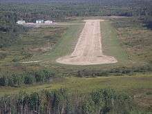
On short final
Bloodvein River Airport, (IATA: YDV, ICAO: CZTA), is located adjacent to Bloodvein River, Manitoba, Canada and serves the Bloodvein First Nation.[1]
References
- 1 2 Canada Flight Supplement. Effective 0901Z 19 July 2018 to 0901Z 13 September 2018.
- ↑ Total aircraft movements by class of operation
External links
- Page about this airport on COPA's Places to Fly airport directory
| By name | |
|---|---|
| By location indicator | |
| By province/territory | |
| By area | |
| National Airports System | |
| Related | |
| |
This article is issued from
Wikipedia.
The text is licensed under Creative Commons - Attribution - Sharealike.
Additional terms may apply for the media files.