Block, Kansas
| Block, Kansas | |
|---|---|
| Unincorporated community | |
 KDOT map of Miami County (legend) | |
 Block  Block | |
| Coordinates: 38°30′18″N 94°48′29″W / 38.50500°N 94.80806°WCoordinates: 38°30′18″N 94°48′29″W / 38.50500°N 94.80806°W | |
| Country | United States |
| State | Kansas |
| County | Miami |
| Elevation[1] | 869 ft (265 m) |
| Time zone | UTC-6 (CST) |
| • Summer (DST) | UTC-5 (CDT) |
| Area code | 913 |
| GNIS ID | 479741 [1] |
Block (also Block Corners) is an unincorporated community in Miami County, Kansas, United States.[1][2]
References
Further reading
External links
Municipalities and communities of Miami County, Kansas, United States | ||
|---|---|---|
| Cities | 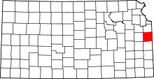 | |
| CDPs | ||
| Unincorporated communities | ||
| Footnotes | ‡This populated place also has portions in an adjacent county or counties | |
This article is issued from
Wikipedia.
The text is licensed under Creative Commons - Attribution - Sharealike.
Additional terms may apply for the media files.