Blampied, Victoria
| Blampied Victoria | |
|---|---|
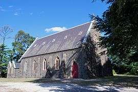 St Joseph's Roman Catholic church | |
 Blampied | |
| Coordinates | 37°22′0″S 144°03′0″E / 37.36667°S 144.05000°ECoordinates: 37°22′0″S 144°03′0″E / 37.36667°S 144.05000°E |
| Population | 212 (2016 census)[1] |
| Postcode(s) | 3364 |
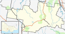
| Location |
|
| LGA(s) | Shire of Hepburn |
| State electorate(s) | Ripon |
| Federal Division(s) | Ballarat |
Blampied is a town in the central highlands of Victoria on the Midland Highway. The town is in the Shire of Hepburn, 117 kilometres (73 mi) north west of the state capital of Melbourne. At the 2016 census, Blampied and the surrounding area had a population of 212.[1]
The town was named after Louis Blampied who built a hotel here which is now called the Swiss Mountain Inn.[2]
Blampied Post Office opened on 20 November 1879 and closed in 1971.[3]
References
- 1 2 Australian Bureau of Statistics (27 June 2017). "Blampied (State Suburb)". 2016 Census QuickStats. Retrieved 9 July 2017.

- ↑ Darwin, Norm. "Neighbours - Towns of Daylesford & district". Pandora archive. Archived from the original on 1999-06-04. Retrieved 2009-01-04.
- ↑ Premier Postal History. "Post Office List". Retrieved 2008-04-11.
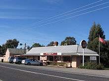
The Swiss Mountain Hotel
| Wikimedia Commons has media related to Blampied, Victoria. |
This article is issued from
Wikipedia.
The text is licensed under Creative Commons - Attribution - Sharealike.
Additional terms may apply for the media files.