Blairgowrie railway station
| Blairgowrie | |
|---|---|
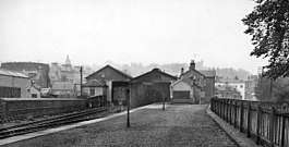 The station in 1961 | |
| Location | |
| Place | Blairgowrie and Rattray |
| Area | Perth and Kinross |
| Coordinates | 56°35′25″N 3°20′06″W / 56.5904°N 3.335°WCoordinates: 56°35′25″N 3°20′06″W / 56.5904°N 3.335°W |
| Grid reference | NO181450 |
| Operations | |
| Original company | Scottish Midland Junction Railway |
| Pre-grouping | Caledonian Railway |
| Post-grouping | London, Midland and Scottish Railway |
| Platforms | 2 |
| History | |
| 1 August 1855 | Station opened |
| 6 December 1965 | Station closed completely |
| Disused railway stations in the United Kingdom | |
|
Closed railway stations in Britain A B C D–F G H–J K–L M–O P–R S T–V W–Z | |
|
| |
Blairgowrie railway station served the burgh of Blairgowrie and Rattray, Perth and Kinross, Scotland from 1855 to 1955 on the Scottish Midland Junction Railway.
History
The station opened on 1 August 1855 by the Scottish Midland Junction Railway, situated on a branch line from Coupar Angus.
It closed to passengers on 10 January 1955 and goods traffic on 6 December 1965.[1][2] Its former location is now the site of a Tesco supermarket; nearby streets retain railway-themed names.
References
- ↑ "Blairgowrie Station". Canmore. Retrieved 19 February 2018.
- ↑ "Outside Blairgowrie Railway Station". Discover Blairgowrie. Retrieved 19 February 2018.
External links
| Preceding station | Historical railways | Following station | ||
|---|---|---|---|---|
| Rosemount Line and station closed |
Scottish Midland Junction Railway | Woodside and Burrelton Line and station closed | ||
This article is issued from
Wikipedia.
The text is licensed under Creative Commons - Attribution - Sharealike.
Additional terms may apply for the media files.