Blair Athol, Queensland
| Blair Athol Queensland | |
|---|---|
| Established | 4721 |
| LGA(s) | Isaac Region |
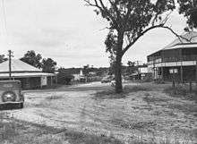
Blair Athol is a former town within Clermont in the Isaac Region, Queensland, Australia.[1] It was obliterated by the development of the Blair Athol coal mine.
History
Early settler James MacLaren took up a pastoral run in the area in 1863 and named it Blair Athol after the village Blair Atholl, the location of Blair Castle of the Duke of Atholl in Scotland.[1] While sinking a well in 1864, he discovered coal on the property.[2]
By 1873, early shafts were dug, revealing extensive seams of coal. At that time, around 100 people were living in the town and there was a hotel, although no township had been officially surveyed.[3] The town was surveyed in 1878.[4]
Blair Athol Provisional School opened on 6 November 1893. It became a State School in 1909.[5][6] Blair Athol Blair Athol Post Office opened on 1 July 1927 (a receiving office had been open from 1910) and closed in 1966.[7]
On 18 May 1922, the Queensland Governor Matthew Nathan officially opened Australia's first open cut mine at Blair Athol.[8]
By the 1970s, it became apparent that there were significant coal seams under the town. In order to construct an open cut mine, the town had to be sacrificed.[2]
The school closed on 31 December 1974.[5]
In 1981 a reunion was held at the community hall to mark the final end of the town, following which all of the town was demolished. Only the cemetery remains.[2]
References
- 1 2 "Blair Athol (entry 3138)". Queensland Place Names. Queensland Government. Retrieved 23 April 2014.
- 1 2 3 Kerogen, Luke. "Coal". Queensland Historical Atlas. Retrieved 25 April 2014.
- ↑ "PEAK DOWNS". Queensland Times, Ipswich Herald & General Advertiser. National Library of Australia. 11 March 1873. p. 4. Retrieved 25 April 2014.
- ↑ "The Morning Bulletin, ROCKHAMPTON". The Morning Bulletin. Rockhampton, Qld.: National Library of Australia. 18 September 1878. p. 2. Retrieved 25 April 2014.
- 1 2 "Opening and closing dates of Queensland Schools". Queensland Government. Retrieved 23 April 2014.
- ↑ "Agency ID6528, Blair Athol State School". Queensland State Archives. Retrieved 25 April 2014.
- ↑ Premier Postal History. "Post Office List". Premier Postal Auctions. Retrieved 10 May 2014.
- ↑ "THE GOVERNOR'S TOUR". The Morning Bulletin. Rockhampton, Qld.: National Library of Australia. 25 May 1922. p. 8. Retrieved 25 April 2014.
Further reading
- Menghetti, Diane (1995), Blair Athol : the life and death of a town, Blair Athol Coal Project, ISBN 978-0-646-26909-2
External links
| Wikimedia Commons has media related to Blair Athol, Queensland. |
- "Blair Athol". Queensland Places. Centre for the Government of Queensland, University of Queensland.
Coordinates: 22°41′49″S 147°32′44″E / 22.69694°S 147.54556°E