Blackpipe, South Dakota
| Blackpipe | |
|---|---|
| Unincorporated community | |
 Blackpipe Location within the state of South Dakota  Blackpipe Blackpipe (the US) | |
| Coordinates: 43°20′38″N 101°16′29″W / 43.34389°N 101.27472°WCoordinates: 43°20′38″N 101°16′29″W / 43.34389°N 101.27472°W | |
| Country | United States |
| State | South Dakota |
| County | Bennett |
| Elevation | 2,917 ft (889 m) |
| Time zone | UTC-7 (Mountain (MST)) |
| • Summer (DST) | UTC-6 (MDT) |
| GNIS feature ID | 1261097[1] |
Blackpipe is an unincorporated community in Bennett County, South Dakota, United States. GNIS also states a post office was there in 1940.
Prior to the opening of a convenience store in 2014, residents had to travel across county lines to Parmelee or White River to get gas. The store was funded by the Rosebud Sioux Tribe and the Four Band Community Fund, Inc. in Eagle Butte.[2]
References
- ↑ U.S. Geological Survey Geographic Names Information System: Blackpipe, South Dakota
- ↑ Waln, Vi (2014-08-07). "Black Pipe Hosts Grand Opening of C-Store". Lakota Country Times. Retrieved 2016-08-15.
Municipalities and communities of Bennett County, South Dakota, United States | ||
|---|---|---|
| City | 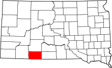 | |
| CDP | ||
| Unorganized territories |
| |
| Unincorporated communities | ||
| Indian reservation | ||
| Footnotes | ‡This populated place also has portions in an adjacent county or counties | |
This article is issued from
Wikipedia.
The text is licensed under Creative Commons - Attribution - Sharealike.
Additional terms may apply for the media files.