Black Cat, Kentucky
| Black Cat | |
|---|---|
| Unincorporated community | |
 Black Cat Location within the state of Kentucky  Black Cat Black Cat (the US) | |
| Coordinates: 36°57′20″N 88°30′8″W / 36.95556°N 88.50222°WCoordinates: 36°57′20″N 88°30′8″W / 36.95556°N 88.50222°W | |
| Country | United States |
| State | Kentucky |
| County | McCracken |
| Elevation | 338 ft (103 m) |
| Time zone | UTC-6 (Central (CST)) |
| • Summer (DST) | UTC-5 (CST) |
| Area code(s) | 270 & 364 |
| GNIS feature ID | 2743766[1] |
Black Cat was an unincorporated community in McCracken County, Kentucky, United States.
References
Municipalities and communities of McCracken County, Kentucky, United States | ||
|---|---|---|
| City | 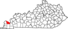 | |
| CDPs | ||
| Unincorporated communities | ||
| Footnotes | ‡This populated place also has portions in an adjacent county or counties | |
This article is issued from
Wikipedia.
The text is licensed under Creative Commons - Attribution - Sharealike.
Additional terms may apply for the media files.