Wong Tai Sin District
| Wong Tai Sin 黃大仙區 | |
|---|---|
| District | |
| Wong Tai Sin District | |
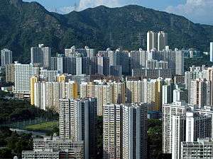
 Day view of San Po Kong in the Wong Tai Sin District | |
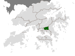 Location of Wong Tai Sin within Hong Kong | |
| Coordinates: 22°20′01″N 114°11′49″E / 22.33353°N 114.19686°ECoordinates: 22°20′01″N 114°11′49″E / 22.33353°N 114.19686°E | |
| Country |
|
| Region | Kowloon |
| Constituencies | 25 |
| Government | |
| • District Council Chairman | Li Tak-hong, JP (DAB) |
| • District Officer | William Shiu |
| Area | |
| • Total | 9.36 km2 (3.61 sq mi) |
| Population (2011[1]) | |
| • Total | 420,183 |
| • Density | 45,000/km2 (120,000/sq mi) |
| Time zone | UTC+8 (Hong Kong Time) |
| Website | Wong Tai Sin District Council |
| Wong Tai Sin District | |||||||||||||||
| Traditional Chinese | 黃大仙區 | ||||||||||||||
|---|---|---|---|---|---|---|---|---|---|---|---|---|---|---|---|
| Simplified Chinese | 黄大仙区 | ||||||||||||||
| Literal meaning | big yellow immortal district | ||||||||||||||
| |||||||||||||||
Wong Tai Sin District (Chinese: 黃大仙區; Cantonese Yale: Wòhngdaaihsīn kēui) is one of the 18 districts of Hong Kong. It is the only fully landlocked district in Hong Kong. It is located in Kowloon.
Geography
The district contains the areas of Diamond Hill, Wang Tau Hom, Lok Fu, Chuk Yuen, Wong Tai Sin, Tsz Wan Shan, Fung Wong, Choi Hung and Choi Wan, an area that includes several major public housing estates.
Demographics
Wong Tai Sin District has a population of 444,630 (2001 figures). The district has the least educated residents with the lowest income, the oldest residents and the second highest population density. Over 85% of the district's residents live in public housing.
Religion
The district derives its name from the Wong Tai Sin Temple, dedicated to Wong Tai Sin, which is located there. The district is also the location of the Chi Lin Nunnery, built in the Tang Dynasty style, a popular tourist attraction.
Education
Schools in Wong Tai Sin District include:
- Our Lady's Primary School (聖母小學), established in 1953
- Wong Tai Sin Catholic Primary School (黃大仙天主教小學), established in 1962.
- Bishop Walsh Primary School (華德學校), established in 1963.
- Baptist Rainbow Primary School (浸信會天虹小學), established in 1984.
Transport
Wong Tai Sin is served by Lung Cheung Road and the Kwun Tong Line of the MTR metro system. The stations are Lok Fu, Wong Tai Sin, Diamond Hill and Choi Hung. The old airport was located just behind this district.
Gallery
 Several public housing estates located in Wong Tai Sin |
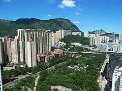 Diamond Hill |
See also
References
- ↑ "2011 Population Census: Summary Results" (in English and Chinese). Census and Statistics Department, Hong Kong Government. 2011. Retrieved 2012-06-11.
External links
- Wong Tai Sin District Council
- District Council Election 2007 - Electoral Boundary Maps - Wong Tai Sin (6.7MB pdf file)
- Wong Tai Sin 黃大仙 Articles on, and photos and videos of, the district and places accessible from Wong Tai Sin station.
Places adjacent to Wong Tai Sin District | ||||||||||
|---|---|---|---|---|---|---|---|---|---|---|
| ||||||||||