Tsz Wan Shan
.jpg)
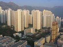
Tsz Wan Shan (Chinese: 慈雲山; Jyutping: ci4 wan4 saan1) is a residential area in Kowloon, Hong Kong. Located below Temple Hill, it is administratively part of Wong Tai Sin District. (Note that Temple Hill is also called Tsz Wan Shan 慈雲山, but Tsz Wan Shan usually refers to the area).
It is a densely populated residential area, consisting of several large public housing estates. The old Tsz Wan Shan housing blocks (64 buildings in total) were demolished between late 1980s and mid 1990s.
Features
Po Kong Village Road Park is located at 140 Po Kong Village Road. There are elevated cycling track (about 1 kilometre in length), cycling area and skater park. Three vertical rams of different difficulty levels are constructed for co-use by players of extreme sports, namely freestyle BMX, skateboarding and aggressive inline skating.[1]
In the very north of the district, a steep path leads to a Kwun Yam temple. The path goes to Temple Hill, part of the Ma On Shan Country Park and then joins the MacLehose Trail and the Wilson Trail, reaching across the New Territories.
Schools
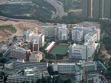
The first school village in Hong Kong was established in 2002 at Po Kong Village Road, Tsz Wan Shan. There are five schools including International Christian Quality Music Secondary and Primary School, Tsz Wan Shan Catholic Primary School, Po Leung Kuk Grandmont Primary School, St. Patrick's Catholic Primary School (Po Kong Village Road) and Po Leung Kuk Celine Ho Yam Tong College.
Transport
The only public transport access to the area is by bus (mainly KMB), green minibus (i.e. No. 37M from Wong Tai Sin, No. 20 from San Po Kong, No. 19M from Diamond Hill, No. 73M from Kowloon Tong, No. 74 from Chuk Yuen), and red minibus (i.e. from Mongkok, from Tsuen Wan, from Causeway Bay and from Castle Peak Road).
Due to the height and the steep inclination of the mountain, there are no railway connections at Tsz Wan Shan. In February 2008, during a site inspection for the Sha Tin to Central Link, the then Secretary for Transport and Housing, Eva Cheng, said the hilly terrain and geological conditions in Tsz Wan Shan made it technically difficult and risky to build a station in this location,[2] despite strong requests from Wong Tai Sin District Council and many local residents.[3]
See also
References
- ↑ Cycling tracks Archived 13 September 2014 at the Wayback Machine. "Archived copy". Archived from the original on 13 September 2014. Retrieved 13 September 2014. 23 April 2014
- ↑ Government to study Tsz Wan Shan pedestrian access to rail station http://www.info.gov.hk 2 February 2008
- ↑ Panel of Transport - Minutes of Hong Kong Legislative Council special meeting held on Monday, 22 October 2007, at 9:30 am Point 8
| Wikimedia Commons has media related to Tsz Wan Shan. |
Coordinates: 22°20′58″N 114°11′58″E / 22.34943°N 114.19949°E