Birkenwerder
| Birkenwerder | ||
|---|---|---|
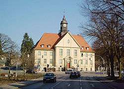 Town hall | ||
| ||
 Birkenwerder Location of Birkenwerder within Oberhavel district 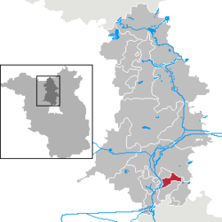 | ||
| Coordinates: 52°41′N 13°17′E / 52.683°N 13.283°ECoordinates: 52°41′N 13°17′E / 52.683°N 13.283°E | ||
| Country | Germany | |
| State | Brandenburg | |
| District | Oberhavel | |
| Government | ||
| • Mayor | Stephan Zimniok | |
| Area | ||
| • Total | 18.10 km2 (6.99 sq mi) | |
| Elevation | 32 - 56 m (−152 ft) | |
| Population (2017-12-31)[1] | ||
| • Total | 8,096 | |
| • Density | 450/km2 (1,200/sq mi) | |
| Time zone | CET/CEST (UTC+1/+2) | |
| Postal codes | 16547 | |
| Dialling codes | 03303 | |
| Vehicle registration | OHV | |
| Website | www.birkenwerder.de | |

Birkenwerder is a municipality in the Oberhavel district, in Brandenburg, Germany.
Geography
Birkenwerder is situated in the south of Oberhavel. The northern border of Berlin is 3 kilometres away. Birkenwerder shares his border with Oranienburg in the north, Mühlenbecker Land in the east and Hohen Neuendorf in the south and in the north. In the centre of Birkenwerder is the river Briese. In the west of Birkenwerder it empties in the River Havel. Briese and Lindenhof are districts (Wohnplätze) of Birkenwerder. More than 50% of the area consists of forest. There are many forest roads, also along the river Briese. Birkenwerder is connected to the motorway A 10 (Bundesautobahn 10), the B 96 (Bundesstraße 96) and the B 96a which ends in the centre of Birkenwerder.
Demography
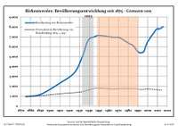 Development of population since 1875 within the current boundaries (blue line: population; dotted line: comparison to population development of Brandenburg state)
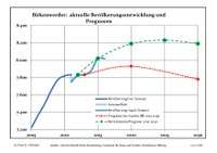 Recent Population Development (Blue Line) and Forecasts
| Birkenwerder: Population development within the current boundaries (2013)[2] | ||||||||||||||||||||||||||||||||||||||||||||||||||||||||||||||||||||||||||||||||||||||||||||||||||||||||||||||||||||||||||||||||||||||
|---|---|---|---|---|---|---|---|---|---|---|---|---|---|---|---|---|---|---|---|---|---|---|---|---|---|---|---|---|---|---|---|---|---|---|---|---|---|---|---|---|---|---|---|---|---|---|---|---|---|---|---|---|---|---|---|---|---|---|---|---|---|---|---|---|---|---|---|---|---|---|---|---|---|---|---|---|---|---|---|---|---|---|---|---|---|---|---|---|---|---|---|---|---|---|---|---|---|---|---|---|---|---|---|---|---|---|---|---|---|---|---|---|---|---|---|---|---|---|---|---|---|---|---|---|---|---|---|---|---|---|---|---|---|---|
|
|
| ||||||||||||||||||||||||||||||||||||||||||||||||||||||||||||||||||||||||||||||||||||||||||||||||||||||||||||||||||||||||||||||||||||
References
- ↑ "Bevölkerung im Land Brandenburg nach amtsfreien Gemeinden, Ämtern und Gemeinden 31. Dezember 2017 (Fortgeschriebene amtliche Einwohnerzahlen auf Grundlage des Zensus 2011)". Amt für Statistik Berlin-Brandenburg (in German). 2018.
- ↑ Detailed data sources are to be found in the Wikimedia Commons.Population Projection Brandenburg at Wikimedia Commons
Towns and municipalities in Oberhavel | ||
|---|---|---|
| Authority control |
|---|