Bihu Loukon
| Bihu Loukon | |
|---|---|
| Maklang, Manipur, India | |
 Bihu Loukon | |
| Coordinates | 24°48′19″N 93°49′10″E / 24.8052141°N 93.8195098°E |
| Height | 8 feet (2.4 m)[1] |
| Site information | |
| Owner |
|
| Controlled by | Archeological Survey of India |
| Open to the public | Yes |
| Condition | Dilapidated |
| Site history | |
| Materials | Mud fort |
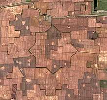
Bihu Loukon is an ancient star shaped mud fort located at Maklang, Imphal West in the Manipur state of North-Eastern India.[2][3] The mud ramparts which are approximately about 15 feet thick and about 5 feet in height. Each triangular arm of the star shaped fort is about 156 feet in length. The fort has eight arms encompassing a circumference of around 5/6 hectares, or 538,000 to 646,000 square feet.
Summary
The mud ramparts has been there since ancient times and used to be a lot thicker and higher. There was also a long canal where boats were raced. The area is also called ‘Thangapat’ now, but the canal had dried up and was consequently converted to arable land. There is another rectangular jig-saw shaped figure of mud wall, located about 200 feet approximately from the star shaped fort.This rectangular jig-saw shaped figure of mud wall surrounded the star shaped fort.It is said that this rectangular jig-saw shaped wall looked like Pakhangba Paphan (the loop of the dragon god Lord Pakhangba) Though much of the ramparts of the outer barrier has eroded with time and farming activity around it, the fort has remained in a much better condition. The design of the fort is star shaped, which is obvious only on satellite imagery and not from the ground perspective. The place was believed to be ruled by a king called Chakpa Charairongba. The star shaped fort may have been built with a military strategy as there are twin mud ramparts of different designs and the area is located with waterways on every direction. The age of the fort or the era in which it was built has not been verified as research is still underway.
According to an archeologist, Nanjesh Thongbam, the discovery of the fort was made somewhere in early 2013 when someone reported seeing the outline on Google Earth to the Kangla Fort Board. Although the age of the fort has not been established, Nanjesh Thongam, believes that radiometric dating can confirm its age but, for one, he is convinced that the fort is older than the Kangla Palace, Imphal, Manipur, India, as the mud structure is devoid of bricks. The site of the fort seems to be shrouded in local myths and it is said that cutting down of Heibi trees around the site brings bad omen, even death.Locals said there were seven Heibi trees in each corner of the rectangular jig-saw shaped wall,but only one Heibi tree is growing till now. Those who cut down the trees died soon.
As of November 2013, the state government declared Bihu Loukon a historical site.[4]
References
- ↑ "Manipur Times". The Peoples Chronicle. Retrieved 13 October 2015.
- ↑ Imphal Free Press (3 March 2013). "Ancient star shaped mud fort discovered at Maklang, Manipur". Kanglaonline.com. Retrieved 23 September 2015.
- ↑ "One-day seminar held". The Sangai Express. 9 June 2015. Retrieved 23 September 2015.
- ↑ "Bihu Loukon - The Sangai Express". The Sangai Express. 2013-11-03. Retrieved 2018-06-30.