Big Sable River
| Big Sable River | |
|---|---|
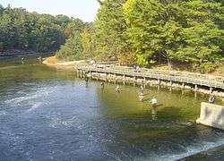 Fishing on the Big Sable, just below Hamlin Lake Dam | |
| Country | United States |
| Physical characteristics | |
| Main source |
confluence of Sauble Lakes chain and Bloody-Run Creek in Lake County, Michigan 44°03′38″N 85°56′11″W / 44.060564°N 85.93646°W[1] |
| River mouth |
Lake Michigan, Mason County, Michigan 44°01′49″N 86°30′25″W / 44.03028°N 86.50703°WCoordinates: 44°01′49″N 86°30′25″W / 44.03028°N 86.50703°W |
| Length | 52 mi (84 km) |
The Big Sable River is a 52-mile-long (84 km)[2] river in Michigan in the United States. It originates in Lake County in the chain of lakes known as Sauble Lakes and flows across Lake and Mason counties. It is dammed to form Hamlin Lake, and below the dam continues through Ludington State Park to empty into Lake Michigan. It is not navigable for the most part, but the section between Hamlin Lake and Lake Michigan is popular for tubing. It is considered an excellent river for fishing. It appears on maps as both "Big Sable" and "Big Sauble".
See also
References
- ↑ "Big Sable River". Geographic Names Information System. United States Geological Survey.
- ↑ U.S. Geological Survey. National Hydrography Dataset high-resolution flowline data. The National Map Archived 2012-04-05 at WebCite, accessed November 21, 2011
External links
| Wikimedia Commons has media related to Big Sable River. |
This article is issued from
Wikipedia.
The text is licensed under Creative Commons - Attribution - Sharealike.
Additional terms may apply for the media files.