Big Four Mountain
| Big Four Mountain | |
|---|---|
 Big Four Mountain | |
| Highest point | |
| Elevation | 6,160+ feet (1,880+ m) [1] |
| Prominence | 1,080 ft (330 m) [1] |
| Coordinates | 48°02′35″N 121°31′26″W / 48.0431619°N 121.524004°WCoordinates: 48°02′35″N 121°31′26″W / 48.0431619°N 121.524004°W [2] |
| Geography | |
| Location | Snohomish County, Washington, U.S. |
| Parent range | Cascade Range |
| Topo map | USGS Silverton |
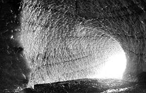
Big Four is a mountain in the Cascade Range, located about 20 miles (32 km) east of Granite Falls, Washington. Debris piles on the mountain's northern flank form as a result of avalanche activity. These fields of disturbed snow are able to remain year round in the shadow of the mountain. During the summer months snow-melt streams flow beneath the debris piles and cause caves to form in the ice. The caves vary in size from season to season and are unpredictably dangerous. The mountain is open to the public and a large snowfield can be reached by a short trail, but the snowfield itself is off-limits due to cave-ins and slides which have killed hikers in incidents in 1998, 2010, and 2015.[3]
History
Big Four is not named for the five peaks on its top but either for a figure 4 that is visible in one of its snowfields, or 4 husky brothers who were prospecting and trapping in the valley.[4]
See also
References
- 1 2 "Big Four Mountain, Washington". Peakbagger.com. Retrieved 2008-11-26.
- ↑ "Big Four Mountain". Geographic Names Information System. United States Geological Survey. Retrieved 2008-11-26.
- ↑ "Girl killed by falling ice at Big Four Ice Caves identified". Seattle Times. August 2, 2010.
- ↑ "History of Darrington > Origin Of Area Names > Big Four Mountain". Archived from the original on March 6, 2016. Retrieved May 30, 2016.
External links
- "Big Four Mountain". SummitPost.org. Retrieved 2011-05-07.