Big Four Ice Caves
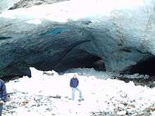
Big Four Mountain is a mountain in the Cascade Range of Washington, located 21 miles (34 km) east of Granite Falls. The mountain is about 6,180 ft (1,880 m) high. At the bottom of its steep, 4,200 ft (1,300 m) high north face, debris piles form from avalanches and are able to remain there year round because of the continuous shade provided by the mountain. At an elevation between 2,450 ft (750 m) and 1,950 ft (590 m), this ice forms the lowest-elevation glacier in the lower 49 states.[1] During the summer, snow-melt streams flow beneath the debris piles and cause caves to be formed in the ice.
The Big Four Ice Caves Trail, a designated National Recreation Trail,[1] (#723) is one of the most popular hikes in the Mount Baker-Snoqualmie National Forest attracting over 50,000 visitors per year. Frequently exceeding several hundred hikers per day, the trailhead's two separate parking areas are often filled beyond capacity occasionally forcing hikers to park along neighboring Mountain Loop Road.
A severe autumn storm in November 2006 caused flooding of the South Fork Stillaguamish River destroying a major footbridge to the Big Four Ice Caves. Estimated repair costs to replace the damaged span were approximately $425,000, and repairs were completed in June 2009.[2] While the trail is open to the public, the snowfield itself was closed temporarily[3] due to cave-ins and slides which have killed four hikers in incidents in 1998, 2010, and in 2015.[4][5]
References
- 1 2 "Big Four Ice Caves Trail". American Trails. 2011-06-08. Retrieved 2014-08-14.
- ↑ "Trail to ice caves reopens Saturday". Everett Herald. June 26, 2009. Retrieved July 1, 2009.
- ↑ Bray, Kari (February 14, 2016). "After deaths, Big Four Ice Caves to reopen with new signs". The Everett Herald. Retrieved January 11, 2018.
- ↑ "Girl killed by falling ice at Big Four Ice Caves identified". Seattle Times. August 2, 2010.
- ↑ "One killed, four injured in Snohomish Big Four Ice Caves collapse Monday". Seattle Times. July 6, 2015.
External links
- "US Forest Service, Mt Baker-Snoqualmie National Forest, Big Four Ice Caves Trail". usda.
- "Washington Trails Association, Big Four Ice Caves Trail". Washington Trails Association.
Coordinates: 48°03′14″N 121°31′11″W / 48.0539°N 121.5196°W