Bethany, Nebraska
| Bethany, Nebraska | |
|---|---|
| Neighborhood | |
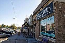 Cotner Boulevard in the Bethany neighborhood in Lincoln, NE. | |
| Coordinates: Community 40°49′57″N 96°38′00″W / 40.83250°N 96.63333°WCoordinates: Community 40°49′57″N 96°38′00″W / 40.83250°N 96.63333°W | |
| Country | United States |
| State | Nebraska |
| County | Lancaster |
| Incorporated | 1890 |
| Annexed by Lincoln, Nebraska | 1922 |
| Elevation | 1,224 ft (373 m) |
| Time zone | UTC-6 (Central (CST)) |
| • Summer (DST) | UTC-5 (CDT) |
| ZIP code | 68505 |
| Area code(s) | 402 |
| FIPS code | 31-04720 |
| GNIS feature ID | 827360[1] |
Bethany is a neighborhood and former town in the northeast region of the city of Lincoln, Nebraska.[2]
History
In 1889, Nebraska Christian University was established east of University Place, a town east of Lincoln centered around Nebraska Wesleyan University.[3] The town was incorporated as Bethany Heights in 1890 and the college was renamed Cotner College.[3] The town was named after the biblical village of Bethany, Israel.[4]
Bethany Heights did not enjoy the same success as Lincoln's other satellite communities.[5] In 1920, Bethany Heights reported a population of 1,078.[5] By comparison, University Place and College View, two other suburbs centered around religious colleges, reported populations of over 4,000 and 2,200 respectively in 1920.[5] Havelock, a suburb near Bethany, reported 3,600 residents in 1920.[5] Residents of Bethany Heights relied upon Lincoln for most services, including hospitals, lawyers, doctors, train depots, hotels, dry goods, and even cemeteries.[5] Due to this reliance, the town voted to be annexed as Bethany by the city of Lincoln in 1922.[3] However, the annexation did not come into effect until 1926 because its neighbor, University Place, had to be annexed first in order to create contiguous city limits.[3]
Unlike other Lincoln suburbs, such as Havelock, University Place, and College View, very little remains of the original town.[5] Cotner College was demolished in the early 1950s and the land on which it stood was divided into single-family residential lots.[5] The First State Bank of Bethany Heights is one of few landmarks from the original town and is not closely associated with the college or the town's foundation.[5]
See also
References
- ↑ "US Board on Geographic Names". United States Geological Survey. 2007-10-25. Retrieved 2008-01-31.
- ↑ U.S. Geological Survey Geographic Names Information System: Bethany, Nebraska
- 1 2 3 4 "Lincoln Lancaster County". University of Nebraska-Lincoln Virtual Nebraska. Retrieved 3 May 2015.
- ↑ Fitzpatrick, Lillian L. (1960). Nebraska Place-Names. University of Nebraska Press. p. 91. ISBN 0-8032-5060-6. A 1925 edition is available for download at University of Nebraska—Lincoln Digital Commons.
- 1 2 3 4 5 6 7 8 "Beattie, James A., House". National Register of Historic Places.
Municipalities and communities of Lancaster County, Nebraska, United States | ||
|---|---|---|
| Cities | ||
| Villages | ||
| CDPs | ||
| Other unincorporated communities | ||
| Footnotes | ‡This populated place also has portions in an adjacent county or counties | |