Bersabe
| באר שבע | |
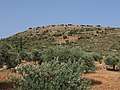
 View from atop of Bersabe (Khirbet Abu esh-Sheba) | |
 Shown within Mandatory Palestine  Bersabe (Israel) | |
| Alternative name | Beer Sheba of the Galilee |
|---|---|
| Location |
|
| Region | Between Upper and Lower Galilee |
| Coordinates | 32°55′23″N 35°25′07″E / 32.92306°N 35.41861°ECoordinates: 32°55′23″N 35°25′07″E / 32.92306°N 35.41861°E |
| History | |
| Periods | Iron Age, Persian, Hellenistic, Roman, Byzantine, Arab |
| Cultures | Jewish, Greco-Roman |
| Site notes | |
| Excavation dates | 1976, 1985, 2000, 2004 |
| Archaeologists | Mordechai Aviam, Oren Tal - Y. Tepper - Alexander Fantalkin, Uzi Leibner |
| Condition | Ruin |
Bersabe (Hebrew: באר שבע);(Greek: Βηρσαβέ), or Beer Sheba of the Galilee, was a Second Temple period Jewish village located near the town of Kefar Hananya which marked the boundary between the Upper Galilee and the Lower Galilee, as described by Josephus,[1][2] with Upper Galilee stretching from Bersabe in the Beit HaKerem Valley to Baca (Peki'in) in the north. Bersabe was one of several towns and villages of Galilee fortified by Josephus during the First Jewish–Roman War,[3] being one of the most defensible positions[4] and where insurgents from across Galilee had taken-up refuge against the Imperial Roman army when the surrounding countryside was plundered.[5]
The ancient village has been identified with the present site of Khirbet es-Saba, a hilltop ruin within a distance of less than a kilometer of the village Kafr 'Inan (Kefr ʿAnan), at the eastern fringe of the Beit HaKerem Valley, and rising some 472 metres (1,549 ft) above sea-level.[6] The same site has been rendered by other authors under the name Khirbet Abu esh-Shebaʿ, a little northwest of Kefr ʿAnan and closely adjoining Farradiyya/Parod to their southwest.[7][8] The site lies 5 kilometres (3.1 mi) eastward of the Arab town of er-Rameh, along Route 85, and about 8 kilometres (5.0 mi) southwest of Safed.
In 1873, Kitchener and Conder, on a surveying mission with the Palestine Exploration Fund, visited the site and mentioned it as being "a large ruin, which stands upon the terraced hill top."[9] A survey later conducted at the site reveal that the village had occupied an area of about 70 dunams (17.3 acres).[10]
From a prospect on Mount Kefir in the Mount Meron range, as one looks out over the hilltop ruin of Bersabe, the square layout or lines where once stood the walls of the town can still be distinguished.[11] The line of the ancient wall extended over an area comprising the upper third of the hill.[10] The thickness of the northernmost wall, where the hill was easily accessible, is measured at 2.8 metres (9.2 ft), and was built with three semi-circular watch towers. The easternmost wall was built in a zig-zag configuration. The walls were constructed of fieldstones.
Fate of town's defenders
| “ | From one end of Galilee to the other there was an orgy of fire and bloodshed; no horror, no calamity was spared; the only safety for the fugitive inhabitants was in the towns which Josephus had fortified.... | ” |
| — Josephus, The Jewish War 3.59 (3.4.1) [12] | ||
The fate of the town's defenders has not come down in writing, although Josephus alludes to it in his Life's Autobiography (§ 65) where he writes: “...I was in the power of the Romans before Jerusalem was besieged, and before the same time, Jotapata was taken by force, as well as many other fortresses, and a great many of the Galileans fell in the war.” This would have happened in the second year of the war, in the 13th year of Nero's reign, sometime between the capture of Jotapata (in the lunar month of Tammuz) and the capture of Tarichaea (in the month of Elul that same year), and which effectually brought an end to the war in Galilee.[13]
The usual Roman procedure in cases involving open rebellion was to kill the able-bodied men who rose up in rebellion, but to sell into slavery all captive women and children.[14]
Archaeological finds
Potsherds from the Iron Age, Persian, Hellenistic, Roman, Byzantine and Arab periods have been found on the site.[11] Only one square near the ancient wall has been excavated.[15] Mordechai Aviam who excavated the site has noted that the ancient ruin has yielded large quantities of "Galilean Coarse Ware" (GCW)[16] and other Hellenistic and Early Roman shards and coins.[17] Coins found at the site date from the fourth century BCE to the second century CE.[18] Unidentified razed structures and rock-cut cisterns are scattered across the hilltop, as well karst caves.
Pottery found at the site proves the continuation of the settlement deep into the 3rd century CE.[10]
Further reading
- Oren Tal, "Fortifications of Josephus in Beersheba of the Galilee", pub. in: Jerusalem and the Land of Israel: Sefer Arieh Kindler (ed. Amar & Zohar), Museum Eretz Israel: Ramat Gan 2000, pp. 155–163 (Hebrew)
- Meyers, E.M., Strange, J.F., and Groh, D.E., "The Meiron Excavation Project: Archaeological Survey in Galilee and Golan, 1976," in: Bulletin of the American Schools of Oriental Research (No. 230 - April 1978), pp. 1–24
Gallery
 The hill of Bersabe (Kh. Abu esh-Sheba) from western side
 Khirbet Abu esh-Sheba (Bersabe) seen from northern side
.jpg) View from Bersabe in Galilee
View from Bersabe in Galilee.jpg) Steep ascent to Khirbet Abu esh-Sheba (Bersabe)
Steep ascent to Khirbet Abu esh-Sheba (Bersabe).jpg) Cave at Bersabe (Kh. Abu esh-Sheba)
Cave at Bersabe (Kh. Abu esh-Sheba)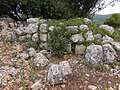 Old wall in Bersabe
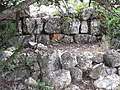 Ruins of Bersabe
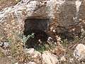 Tomb carved from rock at Bersabe
.jpg) Pit at Bersabe (Khirbet Abu esh-Sheba)
Pit at Bersabe (Khirbet Abu esh-Sheba).jpg) Ruins at Bersabe
Ruins at Bersabe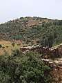 Hilltop ruin of Khirbet Abu esh-Sheba as seen from Farradiyya
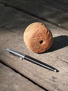 Loom weight discovered in Khirbet Abu esh-Sheba
References
- ↑ Josephus, Vita 188
- ↑ Josephus, De Bello Judaico (Wars of the Jews) II, 572; III, 35 (Wars of the Jews 3.3.1)
- ↑ Josephus, Vita § 37
- ↑ Josephus, De Bello Judaico (Wars of the Jews) II, 572 (Wars of the Jews 2.20.6)
- ↑ Josephus, De Bello Judaico (Wars of the Jews) III, 59 (Wars of the Jews 3.4.1); III, 110 (ibid. 3.6.1)
- ↑ M. Aviam & P. Richardson, "Josephus' Galilee in Archaeological Perspective", published in: Mason, Steve, ed. (2001). Life of Josephus. Flavius Josephus: Translation and Commentary. 9. BRILL. pp. 179;182. ISBN 9004117938.
- ↑ See p. 95 in: Avi-Yonah, Michael (1953). "The Missing Fortress of Flavius Josephus". Israel Exploration Journal. 3 (2): 94–98. JSTOR 27924515.
- ↑ Peter Thomsen, Loca Sancta, Hildesheim 1966, p. 43
- ↑ Conder, Claude Reignier; Kitchener, H. H. (1881). The Survey of Western Palestine: Memoirs of the Topography, Orography, Hydrography, and Archaeology. 1. London: Committee of the Palestine Exploration Fund. ,p. 235.
- 1 2 3 Aviam (2008), p. 41
- 1 2 See p. 38 in: Aviam, Mordechai (1983). "The Location and Function of Josephus' Fortifications in Galilee". Cathedra: For the History of Eretz Israel and Its Yishuv. 28: 33–46. JSTOR 23398973.
- ↑
Josephus (ed. G.A. Williamson). "The Jewish War". Penguin Books. Missing or empty
|url=(help);|access-date=requires|url=(help) - ↑ Josephus, De Bello Judaico (Wars of the Jews 4.1.1)
- ↑ As in the case of Jotapata (Wars of the Jews 3.336), Tarichaea (Wars of the Jews 3.532), Japha (Wars of the Jews 3.289), Machaerus (Wars of the Jews 7.216, in Penguin edition), Gerasa (Wars of the Jews 4.486), with Gamla being the only exception where men, women and children were killed.
- ↑ Aviam (2004), p. 92
- ↑ These ceramic ware vessels are coarse and handmade (only the rim is sometimes finished on a wheel) and the brown-red ware is characterized by the use of large inclusions, thus named by Mordechai Aviam "Galilean Coarse Ware" (GCW). This ware first appeared during the Persian period and was used extensively during the Hellenistic period (Frankel et al. 2001).
- ↑ Aviam (2004), p. 63
- ↑ Aviam (2004), p. 95
Bibliography
- Aviam, Mordechai (2004). Jews, Pagans and Christians in the Galilee (Land of Galilee 1), University of Rochester Press: Rochester. ISBN 1-58046-171-9
- Aviam, Mordechai (2008). The Great Revolt in Galilee (Exhibition Catalogue 28), Hecht Museum, University of Haifa: Haifa, pp. 39–52 ISBN 965-7034-18-3
External links
- Survey of Western Palestine, Map 4: IAA, Wikimedia commons
- Beer Sheba of the Galilee