Berrien Springs, Michigan
| Berrien Springs, Michigan | |
|---|---|
| Village | |
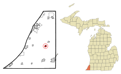 Location of Berrien Springs, Michigan | |
| Coordinates: 41°56′51″N 86°20′25″W / 41.94750°N 86.34028°WCoordinates: 41°56′51″N 86°20′25″W / 41.94750°N 86.34028°W | |
| Country | United States |
| State | Michigan |
| County | Berrien |
| Area[1] | |
| • Total | 1.02 sq mi (2.64 km2) |
| • Land | 0.94 sq mi (2.43 km2) |
| • Water | 0.08 sq mi (0.21 km2) |
| Elevation | 673 ft (205 m) |
| Population (2010)[2] | |
| • Total | 1,800 |
| • Estimate (2016)[3] | 1,752 |
| • Density | 1,800/sq mi (680/km2) |
| Time zone | UTC-5 (Eastern (EST)) |
| • Summer (DST) | UTC-4 (EDT) |
| ZIP codes | 49103-49104 |
| Area code(s) | 269 |
| FIPS code | 26-07860[4] |
| GNIS feature ID | 2398105[5] |
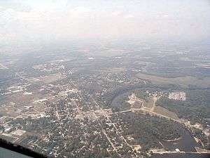
Berrien Springs is a village in Berrien County in the U.S. state of Michigan. The population was 1,800 at the 2010 census. The village is located within Oronoko Charter Township. Berrien Springs is best known for its Seventh-day Adventist community and Andrews University. Reflecting the community's population, many of the businesses in the village are closed on Saturdays.
History
Berrien Springs, like Berrien County, is named for John M. Berrien; "Springs" was added after mineral springs were discovered in the area.[6] The village is the site of the earliest settlement in Oronoko Township, and was first known as "Wolf's Prairie" in reference to the 1,000-acre prairie in which it was situated. The site had been a village under the leadership of a Potawatamie man named Wolf.[7] The first permanent settlers, John Pike and his family, arrived in 1829.[8]
The village of Berrien was platted in 1831,[8] and the village of Berrien Springs was incorporated in 1863.[9] Berrien Springs was the county seat from 1837 until 1894, when St. Joseph became county seat.[10] The Berrien Springs post office opened with the name Berrien on December 4, 1832 and changed to Berrien Springs on April 18, 1836.[11]
1839 Courthouse
When Berrien Springs became the county seat, its courthouse, designed by local architect Gilbert B. Avery, was completed in 1839. The Greek Revival-style courthouse emulated the architecture of ancient Greece with its large columns, triangular pediment and white paint. After the county seat was moved in 1894, the building was put to various uses and briefly was vacant. In 1967, efforts to preserve and restore the courthouse began.[12]
The restored courthouse square contains Michigan's oldest courthouse as part of the Midwest's most complete surviving mid-nineteenth century county government complex. Today the square houses a county museum and archives and serves as headquarters for the Berrien County Historical Association. Its original buildings are listed on the National Register of Historic Places. The gallery on the first floor of the 1839 Courthouse is devoted to exhibits on Berrien County history. Topics covered include early colonial forts, the fur trade, railroads, the Civil War, early Berrien County industries, Native Americans and area pre-history. The Sheriff's House gallery hosts changing exhibits. Classroom programs include living history presentations. Teachers can invite a Civil War soldier or French voyageur to speak to their class.
Geography
According to the United States Census Bureau, the village has a total area of 1.02 square miles (2.64 km2), of which 0.94 square miles (2.43 km2) is land and 0.08 square miles (0.21 km2) is water.[1] The village is situated on the St. Joseph River.
Demographics
| Historical population | |||
|---|---|---|---|
| Census | Pop. | %± | |
| 1870 | 662 | — | |
| 1880 | 758 | 14.5% | |
| 1890 | 745 | −1.7% | |
| 1900 | 808 | 8.5% | |
| 1910 | 880 | 8.9% | |
| 1920 | 918 | 4.3% | |
| 1930 | 1,413 | 53.9% | |
| 1940 | 1,510 | 6.9% | |
| 1950 | 1,761 | 16.6% | |
| 1960 | 1,953 | 10.9% | |
| 1970 | 1,951 | −0.1% | |
| 1980 | 2,042 | 4.7% | |
| 1990 | 1,927 | −5.6% | |
| 2000 | 1,862 | −3.4% | |
| 2010 | 1,800 | −3.3% | |
| Est. 2016 | 1,752 | [3] | −2.7% |
| U.S. Decennial Census[13] | |||
2010 census
As of the census[2] of 2010, there were 1,800 people, 756 households, and 463 families residing in the village. The population density was 1,914.9 inhabitants per square mile (739.3/km2). There were 837 housing units at an average density of 890.4 per square mile (343.8/km2). The racial makeup of the village was 72.7% White, 12.9% African American, 0.4% Native American, 5.1% Asian, 0.4% Pacific Islander, 3.8% from other races, and 4.7% from two or more races. Hispanic or Latino of any race were 12.9% of the population.
There were 756 households of which 30.2% had children under the age of 18 living with them, 40.9% were married couples living together, 16.0% had a female householder with no husband present, 4.4% had a male householder with no wife present, and 38.8% were non-families. 32.0% of all households were made up of individuals and 11.2% had someone living alone who was 65 years of age or older. The average household size was 2.35 and the average family size was 2.95.
The median age in the village was 34.6 years. 22.8% of residents were under the age of 18; 13.1% were between the ages of 18 and 24; 27.2% were from 25 to 44; 23.3% were from 45 to 64; and 13.7% were 65 years of age or older. The gender makeup of the village was 47.9% male and 52.1% female.
2000 census
As of the census[4] of 2000, there were 1,862 people, 732 households, and 475 families residing in the village. The population density was 2,059.6 per square mile (798.8/km²). There were 787 housing units at an average density of 870.5 per square mile (337.6/km²). The racial makeup of the village was 77.12% White, 11.06% African American, 0.43% Native American, 4.03% Asian, 0.16% Pacific Islander, 4.30% from other races, and 2.90% from two or more races. Hispanic or Latino of any race were 8.92% of the population.
There were 732 households out of which 30.2% had children under the age of 18 living with them, 49.2% were married couples living together, 11.6% had a female householder with no husband present, and 35.0% were non-families. 29.8% of all households were made up of individuals and 10.7% had someone living alone who was 65 years of age or older. The average household size was 2.46 and the average family size was 3.05.
In the village, the population was spread out with 23.0% under the age of 18, 11.9% from 18 to 24, 28.7% from 25 to 44, 21.0% from 45 to 64, and 15.3% who were 65 years of age or older. The median age was 36 years. For every 100 females, there were 95.0 males. For every 100 females age 18 and over, there were 88.1 males.
The median income for a household in the village was $32,396, and the median income for a family was $41,250. Males had a median income of $31,467 versus $21,750 for females. The per capita income for the village was $16,093. About 12.4% of families and 17.5% of the population were below the poverty line, including 25.4% of those under age 18 and 4.1% of those age 65 or over.
Schools
Elementary
- Mars Elementary – Public, Grades K-2
- Sylvester Elementary – Public, Grades 3–5
- Berrien Springs Middle School – Public, Grades 6–8
- Trinity Lutheran School – Private, Religious (Lutheran), Grades PreK – 8
- Ruth Murdoch Elementary – Private, Religious (Seventh-day Adventist), Grades K-8
- Village SDA Elementary – Private, Religious (Seventh-day Adventist), Grades K-8
Secondary
- Andrews Academy – Private, Religious (Seventh-day Adventist), Grades 9–12
- Berrien Springs High School – Public, Grades 9–12; team name: Shamrocks; team colors: green and white
Post-secondary
- Andrews University is located outside of town, but still in Oronoko Charter Township. It is serviced by the Berrien Springs post office.
Notable people
- Muhammad Ali, professional boxer, generally considered among the greatest heavyweights in the sport's history; owned a home in the Berrien Springs area.[14][15]
- Regan Upshaw, defensive lineman for five NFL teams; born in Berrien Springs (1975)
References
Notes
- 1 2 "US Gazetteer files 2010". United States Census Bureau. Archived from the original on 2012-07-14. Retrieved 2012-11-25.
- 1 2 "American FactFinder". United States Census Bureau. Retrieved 2012-11-25.
- 1 2 "Population and Housing Unit Estimates". Retrieved June 9, 2017.
- 1 2 "American FactFinder". United States Census Bureau. Archived from the original on 2013-09-11. Retrieved 2008-01-31.
- ↑ U.S. Geological Survey Geographic Names Information System: Berrien Springs, Michigan
- ↑ "Origins - Old Place Names". Berrien County Genealogical Society. Retrieved 13 March 2018.
- ↑ Romig 1986, p. 58.
- 1 2 Coolidge, Orville W. (1906). A Twentieth Century History of Berrien County, Michigan, pp. 198-99. The Lewis Publishing Company.
- ↑ Capace, Nancy (2008-2009 ed.) The Encyclopedia of Michigan 1999, Volume 1, p. 176. Somerset Publishers, Inc.
- ↑ Community Profile, Village of Berrien Springs Archived August 20, 2008, at the Wayback Machine. – Berrien County official site
- ↑ U.S. Geological Survey Geographic Names Information System: Berrien Springs Post Office
- ↑ Fedynsky, John (2010). Michigan's County Courthouses, pp. 24-25. The University of Michigan Press.
- ↑ "Census of Population and Housing". Census.gov. Archived from the original on May 12, 2015. Retrieved June 4, 2015.
- ↑ Tokars, Leanne (2007-01-18). "Muhammad Ali: Still missed in Michigan". South Bend Tribune. Retrieved 2008-07-30.
- ↑ Mumford, Lou (2007-01-21). "Ali's move could sting". South Bend Tribune. Retrieved 2008-07-30.
Sources
- Romig, Walter (October 1, 1986) [1973]. Michigan Place Names: The History of the Founding and the Naming of More Than Five Thousand Past and Present Michigan Communities. Great Lakes Books Series (Paperback). Detroit, Michigan: Wayne State University Press. ISBN 0-8143-1838-X. ISBN 978-0814318386.
Municipalities and communities of Berrien County, Michigan, United States | ||
|---|---|---|
| Cities | 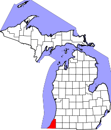 | |
| Villages | ||
| Charter townships | ||
| General law townships | ||
| CDPs | ||
| Other unincorporated communities | ||
| Footnotes | ‡This populated place also has portions in an adjacent county or counties | |