Berlengas
| Berlengas | |
| Archipelago (Arquipélago) | |
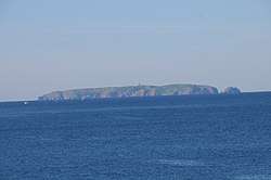 Panoramic view of Berlengas islands. | |
| Official name: Arquipélago das Berlengas | |
| Nickname: Ilhas das Berlengas | |
| Country | |
|---|---|
| Region | Beira |
| Sub-region | Oeste |
| District | Leiria |
| Municipality | Peniche |
| Location | Atlantic Ocean |
| Islands | Berlenga Grande, Estelas, Farilhões, Forcados |
| Landmark | Fort of São João Baptista |
| Highest point | Berlenga Grande |
| - elevation | 75 m (246 ft) |
| - coordinates | 39°24′55″N 9°30′34″W / 39.41528°N 9.50944°W |
| Lowest point | Sea level |
| - location | Atlantic Ocean |
| - elevation | 0 m (0 ft) |
| Length | 1.99 km (1 mi), Northwest-Southeast |
| Width | 8.57 km (5 mi), Southwest-Northeast |
| Area | 0.99 km2 (0 sq mi) |
| Biomes | Temperate, Mediterranean |
| Ethnic groups | Portuguese |
 Location of the archipelago of the Berlengas | |
| Wikimedia Commons: Berlengas | |
The Berlengas archipelago is a group of small islands 10 to 15 kilometres (6.2–9.3 miles) off the Portuguese coast, west of the town of Peniche in Oeste region. These islands were traditionally known to British mariners as "the Burlings".[1][2][3][4] The only habitable island is the largest island, Berlenga Grande, although there is no permanent habitation there at present.[5] The other islands are grouped into two groups of islets, the Estelas Islets and the Farilhões-Forcados Islets.
History
.jpg)
Human occupation on Berlenga Grande dates back to antiquity: the islands are referred to in Ptolemy's Geography as Λονδοβρίς (Londobris).[6] Much later it was referred to as the island of Saturno by Roman geographers, and was visited successively by Muslims, Vikings and pirates/privateers from England and France.
In 1513, with the support of Queen Eleanor of Viseu, monks from the Order of São Jerónimo established a settlement on the island to offer assistance to navigation and victims of frequent shipwrecks. The monastery founded there (the Monastery of the Misericórdia da Berlenga), remained until the 16th century, when disease, lack of communication (due to constant inclement weather) and regular assaults by pirates and privateers (from England and France), forced the monks to abandon their service on the island.
After the Portuguese Restoration War, during the reign of King John IV, the Council of War determined that the demolition of the monastery ruins, and the use of their rocks to build a coastal defense would help protect the coastal settlements; the Fort of São João Baptista das Berlengas was constructed from the remnants of the monastery ruins. By 1655, it had already, during its construction, resisted an assault by three Barbary coast pirates.
The island's lighthouse (dubbed Duke of Braganza by locals) was constructed in 1841. In the 20th century a solar panel was installed in the lighthouse's 29 metres (95 ft) column, providing a 50 kilometres (31 mi) field of vision.
The International Coordinating Council of UNESCO’s Man and the Biosphere Programme (MAB), meeting in Dresden (Germany) from 28 June to 1 July, while adding 18 new sites, included the Berlengas to the World Network of Biosphere Reserves (WNBR): in a statement on 30 June 2011, the list of classified reserves were presented.[7]
Geography
The archipelago is made up of the largest island, Berlenga Grande, and two groups of smaller islets, the Estelas Inlets and the Farilhões-Forcados Islets. As the archipelago has been declared a reservation area for the protection of the local fauna (primarily sea birds), it is only visited by scientists and, in the summer, by a small number of tourists.[8]
There is little soil on the rocky archipelago, so little plant life is supported.[9] Sea birds and marine life, such as mackerel, mullet, and swordfish are abundant.[9]
Berlenga Grande
.jpg)

At 1.5 kilometres (0.93 mi) long and .8 kilometres (0.50 mi) wide, Berlenga Grande is the largest of the islands of the Berlengas Archipelago.[9] At its highest, it rises to 75 m above sea level. The island has a number of notable caves, including the Gruta Azul (English: "Blue Grotto") and the Furado Grande (English: "Big Hole"). The Furado Grande is a natural tunnel 70 metres (230 ft) wide and 20 metres (66 ft) tall which crosses through the entire island before opening up into a dramatic bay.[8][9]
The Fort of São João Baptista (English: "Fort of St. John the Baptist") is located in the waters off the southeastern coast of Berlenga Grande, on a small islet connected to the island by a causeway/arch-bridge and anchorage to the north.[10] It has been retrofitted as a rest house for tourists to stay at while visiting the islands.[8]
Wrecks
A number of ships have wrecked on the Berlengas throughout documented history.
In 1808, HMS Milbrook wrecked on Berlenga Grande in a gale, though without loss of life.[11]
See also
References
- ↑ Wreck Report for SS Corsica 1881
- ↑ Wreck Report for Brixham 1884
- ↑ Catalog of the latest and most approved charts pilots and navigation, published 1817, on Google Books, page 4. Item 62 "The Coast of Portugal including Part of the Coast of Spain from Cape Penas to Gibraltar with particular Plans of the Harbours of Ferrol Corunna Vigo Oporto Lisbon Cádiz and the Burlings drawn from the Surveys of Tofino Franzini and others 7 6"
- ↑ Newspaper report of shipwreck of the Dorunda, which names the location as the Burlings and includes a map
- ↑ Although tourists do travel to the island, there are no fixed residents on this group. Berlenga Grande did star in a pre-revolutionary Portuguese movie called O Rei das Berlengas (English: The King of the Berlengas), a comedy about someone who decides to become king of the said archipelago. Due to this movie, several people, tourists and residents from the nearby towns, have declared the independence of the islands, and declare themselves as king, prince or president of the Berlengas. These declarations and liberation armies are nothing more than fiction intended for amusement.
- ↑ The Geography of Claudius Ptolemy
- ↑ UNESCO, ed. (30 June 2011). "18 new Biosphere Reserves added to UNESCO's Man and the Biosphere (MAB) Programme". Paris, France: UNESCO/Natural Sciences UNESCOPRESS. Retrieved 30 June 2011.
- 1 2 3 Portugal, TCP/ARPT Centro de. "Berlengas • Centro de Portugal". Centro de Portugal. Retrieved 2017-02-21.
- 1 2 3 4 Scheffel, Richard L.; Wernet, Susan J., eds. (1980). Natural Wonders of the World. United States of America: Reader's Digest Association, Inc. p. 78. ISBN 0-89577-087-3.
- ↑ "Monumentos". Archived from the original on 2016-03-05. Retrieved 2017-02-21.
- ↑ Hepper, David J. (1994). British Warship Losses in the Age of Sail, 1650–1859, p. 123. Rotherfield: Jean Boudriot. ISBN 0-948864-30-3