Leiria District
| District of Leiria | |
|---|---|
| District | |
 | |
| Country | Portugal |
| Region | Centro |
| Historical province |
Beira Litoral and Estremadura |
| No. of municipalities | 16 |
| No. of parishes | 148 |
| Capital | Leiria |
| Area | |
| • Total | 3,515 km2 (1,357 sq mi) |
| Population | |
| • Total | 459,450 |
| • Density | 130/km2 (340/sq mi) |
| ISO 3166 code | PT-10 |
| No. of parliamentary representatives | 10 |
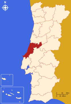
The District of Leiria (Portuguese pronunciation: [lɐjˈɾi.ɐ], Portuguese: Distrito de Leiria) is located in Central Portugal. The district capital is the city of Leiria, which is also the largest and most populous city with about 55,000 in the city/urbanised area.
| Name | Status |
|---|---|
| Alcobaça | C |
| Alvaiázere | T |
| Ansião | T |
| Batalha | T |
| Bombarral | T |
| Caldas da Rainha | C |
| Castanheira de Pera | T |
| Figueiró dos Vinhos | T |
| Leiria | C |
| Marinha Grande | C |
| Nazaré | T |
| Óbidos | T |
| Pedrógão Grande | T |
| Peniche | C |
| Pombal | C |
| Porto de Mós | T |
Summary of votes and seats won 1976-2011
Summary of election results from Leiria district, 1976-2011
| Parties | % | S | % | S | % | S | % | S | % | S | % | S | % | S | % | S | % | S | % | S | % | S | % | S | % | S |
|---|---|---|---|---|---|---|---|---|---|---|---|---|---|---|---|---|---|---|---|---|---|---|---|---|---|---|
| 1976 | 1979 | 1980 | 1983 | 1985 | 1987 | 1991 | 1995 | 1999 | 2002 | 2005 | 2009 | 2011 | ||||||||||||||
| PS | 31.1 | 4 | 23.2 | 3 | 22.7 | 3 | 32.7 | 4 | 19.6 | 2 | 18.7 | 2 | 23.0 | 3 | 36.7 | 4 | 36.8 | 4 | 29.5 | 3 | 35.6 | 4 | 30.1 | 4 | 20.7 | 3 |
| PSD | 31.2 | 4 | 35.6 | 4 | 38.6 | 5 | 60.8 | 9 | 61.2 | 7 | 43.3 | 5 | 42.6 | 5 | 50.8 | 6 | 39.8 | 5 | 34.9 | 4 | 47.0 | 6 | ||||
| CDS-PP | 19.4 | 2 | 16.2 | 2 | 12.2 | 1 | 6.0 | 4.8 | 11.4 | 1 | 9.9 | 1 | 9.8 | 1 | 8.9 | 1 | 12.6 | 1 | 12.8 | 1 | ||||||
| PCP/APU/CDU | 7.3 | 1 | 10.9 | 1 | 9.7 | 1 | 9.5 | 1 | 7.9 | 1 | 5.9 | 4.5 | 4.5 | 5.3 | 4.1 | 4.6 | 5.1 | 5.0 | ||||||||
| BE | 1.7 | 2.2 | 5.5 | 9.5 | 1 | 5.1 | ||||||||||||||||||||
| AD | 56.2 | 7 | 59.8 | 7 | ||||||||||||||||||||||
| PRD | 15.3 | 2 | 3.0 | |||||||||||||||||||||||
| Source: Comissão Nacional de Eleições | ||||||||||||||||||||||||||
See also
- Casal de São Simåo, a village in the district of Leiria
This article is issued from
Wikipedia.
The text is licensed under Creative Commons - Attribution - Sharealike.
Additional terms may apply for the media files.