Berkane
| Berkane Berkan / ⴱⴻⵔⴽⴰⵏ / بركان | |
|---|---|
| City | |
    The clementine, sculpture in the city centre of Berkane | |
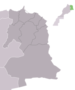
 Berkane Location in Morocco | |
| Coordinates: 34°55′N 2°19′W / 34.917°N 2.317°W | |
| Country |
|
| Region | Oriental |
| Province | Berkane |
| Population (2014)[1] | |
| • Total | 109,237 |
| Time zone | UTC+0 (WET) |
| • Summer (DST) | UTC+1 (WEST) |
| Postal code | 63300 |
Berkane or (Berber: Berkan, ⴱⴻⵔⴽⴰⵏ, Arabic: بَركان) is a city in northeastern Morocco, (in the Rif region), in the area of Trifa, limited by the Mediterranean to its north, the Kiss Oued (Moroccan-Algerian border) and Oujda Province in the east, Nador Province to the west, and Taourirt Province in the south. It is the capital of Berkane Province. The city recorded a population of 109,237 in the 2014 Moroccan census.[1] The inhabitants of Berkane originate primarily from Yat Iznasen, a major tribe which consists of Berber clans. The tribe's descendants are also spread over the rest of eastern Morocco, in cities like Ahfir, Saïdia and Oujda. Because of recent immigration from all over Morocco, the eastern dialect of Moroccan Arabic is spoken by most of the citizens, although Berber is still spoken by many of the adults.
Berkane is considered the capital of the citrus fruit industry of Morocco, and high-quality fresh fruit and vegetables are plentiful year round. It is known for its farms of clementines mostly owned by the pro French protectorate Algerians such as Belhaj or Belhaj Bouabdallah family and the Ex drug lord Hoummad Kantari, also a large statue of an orange is at the center of town. It is very close to Saïdia, a popular beach resort town on the Mediterranean, as well as Tafoughalt, a small village in the nearby mountains known for its healthy air and herb markets. Berkane is also famous for being the birthplace of the Olympic athlete Hicham El Guerrouj, who holds the world record for the fastest mile.
Berkane is a sprawling city centered on Avenue Mohammed V, a commercial and business strip, and boulevard Ibn Sina/Rue Dehb or Alhob(meaning "The Street of Gold and or street of love"), which is lined with many of the most popular cafes and jewelry shops. The city sprawls into the hillsides and connects via bridge to a small neighboring town named Sidi Slimane, giving the impression that it is much larger than the census claims.
The name of the city (Berkan > aberkan) means "black" in the Berber language.
References
- 1 2 "POPULATION LÉGALE DES RÉGIONS, PROVINCES, PRÉFECTURES, MUNICIPALITÉS, ARRONDISSEMENTS ET COMMUNES DU ROYAUME D'APRÈS LES RÉSULTATS DU RGPH 2014" (in Arabic and French). High Commission for Planning, Morocco. 8 April 2015. Retrieved 29 September 2017.
External links
![]()
- Nador Rif News شبكة أخبار الناظور و الريف أريفينو.نت ; www.ariffino.net
- Berkane entry in lexicorient
- Berkane Fort Web Site