Beni Ansar
| Beni Ensar / Aït Nsar Aït Nṣar / بْني نصار ⴰⵢⵝ ⵏⵚⴰⵔ أيث نْصار | |
|---|---|
| Town | |
  .jpg) 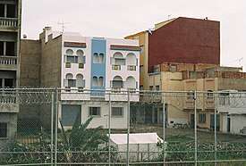 | |
| Coordinates: 35°15′40″N 2°55′51″W / 35.26111°N 2.93083°W | |
| Country |
|
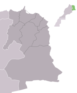
| Region | Oriental |
| Province | Nador |
| Elevation | 37 m (121 ft) |
| Population (2014)[1] | |
| • Total | 56,582 |
| Time zone | UTC+0 (WET) |
| • Summer (DST) | UTC+1 (WEST) |
Beni Ensar or Aït Nsar (Berber: Aït Nṣar or Ayt Nṣar; Arabic: بْني نصار or أيث نصار) is a town in Nador Province, Oriental, Morocco, located 12 km north of the city of Nador. It is bordered on the north by the Spanish-controlled city of Melilla. According to the 2014 census Beni Ensar has a population of 56,582,[1] and its area is 20 hectares (0.2 km²).
The port of Beni Ensar is one of the main ports of Morocco, serving the city of Nador (Beni Ansar port is usually referred to as Nador Port). The urban area is bordered on the west by Mount Gurugu (Adrar n Gurugu) and a highway, and on the east by the Lagoon of Nador (Mar Chica or Řebḥar Ameẓẓyan), the railway, and the industrial zone around the port.
References
| Wikimedia Commons has media related to Beni Ansar. |
- 1 2 "POPULATION LÉGALE DES RÉGIONS, PROVINCES, PRÉFECTURES, MUNICIPALITÉS, ARRONDISSEMENTS ET COMMUNES DU ROYAUME D'APRÈS LES RÉSULTATS DU RGPH 2014" (in Arabic and French). High Commission for Planning, Morocco. 8 April 2015. Retrieved 29 September 2017.
Coordinates: 35°16′00″N 2°56′00″W / 35.266701°N 2.9333°W