Lauterbrunnen–Mürren Mountain Railway
| Lauterbrunnen-Mürren Mountain Railway | ||||||||||||||||||||||||||||||||||||||||||
|---|---|---|---|---|---|---|---|---|---|---|---|---|---|---|---|---|---|---|---|---|---|---|---|---|---|---|---|---|---|---|---|---|---|---|---|---|---|---|---|---|---|---|
 | ||||||||||||||||||||||||||||||||||||||||||
| Overview | ||||||||||||||||||||||||||||||||||||||||||
| Other name(s) | Mürrenbahn, Grütschalpbahn | |||||||||||||||||||||||||||||||||||||||||
| Native name | Bergbahn Lauterbrunnen–Mürren BLM | |||||||||||||||||||||||||||||||||||||||||
| Type | Mountain aerial cableway and mountain railway | |||||||||||||||||||||||||||||||||||||||||
| Status | operating daily with brief maintenance breaks in spring and late autumn | |||||||||||||||||||||||||||||||||||||||||
| Locale | Bernese Highlands | |||||||||||||||||||||||||||||||||||||||||
| Termini |
Lauterbrunnen Mürren | |||||||||||||||||||||||||||||||||||||||||
| Stations | 4[1] | |||||||||||||||||||||||||||||||||||||||||
| Services | 1 | |||||||||||||||||||||||||||||||||||||||||
| Website | BLM | |||||||||||||||||||||||||||||||||||||||||
| Operation | ||||||||||||||||||||||||||||||||||||||||||
| Opened | 1891 (railway), 2006 (aerial cableway) | |||||||||||||||||||||||||||||||||||||||||
| Closed | 2006 (funicular) | |||||||||||||||||||||||||||||||||||||||||
| Owner | Bergbahn Lauterbrunnen-Mürren AG[1] | |||||||||||||||||||||||||||||||||||||||||
| Operator(s) | BLM | |||||||||||||||||||||||||||||||||||||||||
| Character | Small commuter, but mainly touristic mountain rail-/cableway | |||||||||||||||||||||||||||||||||||||||||
| Technical | ||||||||||||||||||||||||||||||||||||||||||
| Line length |
| |||||||||||||||||||||||||||||||||||||||||
| Number of tracks | Single track with one passing loop | |||||||||||||||||||||||||||||||||||||||||
| Track gauge | 1,000 mm (3 ft 3 3⁄8 in)[1] | |||||||||||||||||||||||||||||||||||||||||
| Electrification | 550 V DC, Overhead line[1] | |||||||||||||||||||||||||||||||||||||||||
| Highest elevation | 1,638 m (5,374 ft) | |||||||||||||||||||||||||||||||||||||||||
| Maximum incline | 5%[1] | |||||||||||||||||||||||||||||||||||||||||
| ||||||||||||||||||||||||||||||||||||||||||
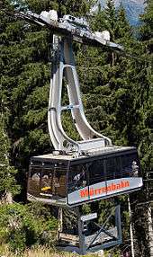

The Lauterbrunnen–Mürren Mountain Railway (German: Bergbahn Lauterbrunnen–Mürren, BLM, also known as Mürrenbahn) is a hybrid transport system in the Bernese Oberland area of Switzerland, which connects the villages of Lauterbrunnen and Mürren. The system consists of a connected aerial cableway, also known as the Grütschalpbahn, and an adhesion worked mountain railway.[1][2][3]
The line provides a vital passenger and goods link to the resort village of Mürren, which is situated above the cliffs of the Lauterbrunnen Valley and has poor road access. It also commands a view of the Eiger, Mönch and Jungfrau mountains across the depths of that valley.[2][4]
The line is owned by the Bergbahn Lauterbrunnen-Mürren AG, a subsidiary of the Jungfraubahn Holding AG, a holding company that also owns the Wengernalpbahn, Jungfraubahn, Harderbahn, and Firstbahn. Through that holding company it is part of the Allianz - Jungfrau Top of Europe marketing alliance, which also includes the separately owned Berner Oberland-Bahn and Schynige Platte-Bahn.[1][5]
History
The key milestones in the history of the line are:
- 1887 Concession obtained for the construction of the railways.
- 1889 The company is formed and construction starts.
- 1891 Railway opens. The planned opening on 1 June is delayed until 14 August due to a derailment.
- 1902 The funicular railway is converted from water gravity power to electric power .
- 1910 First winter operations started.
- 1912 Replacement of the locomotives on the Mürren to Grütschalp section by motor coaches (type BDe 2/4).
- 1949 New vehicles and rope are installed on the Lauterbrunnen to Grütschalp section.
- 1965 The new station at Mürren is opened.
- 1994 The freight loading operations at Grütschalp are rebuilt.
- 2006 Last operation of the funicular from Lauterbrunnen to Grütschalp was on 23 April and the first operation of the replacement cable car was on 16 December.
Route
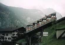
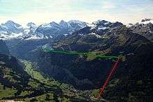
The BLM commences from Lauterbrunnen, using a terminus that is directly opposite the platforms of the Berner Oberland-Bahn (BOB) to Interlaken, and the Wengernalpbahn (WAB) to Kleine Scheidegg and Grindelwald. The first section of the line is an aerial cableway that rises 690 m (2,263.8 ft) in a distance of 1.4 km (0.9 mi). The cableway follows the line of the funicular that preceded it, and the remains of the funicular are visible at many points.[2][6]
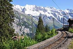
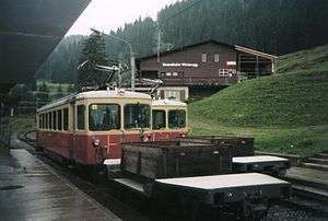
The aerial cableway and railway connect at Grütschalp station, which also contains the line's workshop. From Grütschalp to Mürren the line is continued as a 4.27 km (2.7 mi) long narrow gauge electric railway, which rises 152 m (498.7 ft). Through most of its length, the rail line commands a view of the Eiger, Mönch and Jungfrau across the depths of the Lauterbrunnen Valley.[2][4]
The railway is single-track, with a passing loop at Winteregg station, and runs to a terminus at Mürren, where the platforms used by passengers are enclosed within a modern station building. Just before the station is reached, the line passes a large freight depot, used in the carriage of freight to Mürren.[2]
Operation
The cable car section of the line is operated by a single cable car, which shuttles between Lauterbrunnen and Grütschalp carrying up to 100 passengers and 6 tonnes of freight in a journey time of 4 minutes. The rail section is operated by single electric railcars, often towing or pushing a flat car for goods, with a journey time of 14 minutes. The two are scheduled together to provide a frequency of between two and four services per hour.[7][8]
The rail line has a track gauge of 1,000 mm (3 ft 3 3⁄8 in) and is electrified at 550 V DC supplied by overhead line. The line is operated using rail adhesion only, and has a maximum gradient of 5%. The former funicular shared the same track gauge, enabling the use of the funicular to transfer rolling stock to and from the electric railway.[2][6]
A complex transfer machine in the Grütschalp station is used to transfer goods between the two sections and is well used since road access to Mürren is virtually impossible. The same machine was used to transfer goods between the funicular and rail, and has been retained for use with the cable car.[6]
See also
References
- 1 2 3 4 5 6 7 8 "BLM - Panoramic views from the train". Interlaken, Switzerland: Jungfraubahnen Management AG. Retrieved 2017-05-18.
- 1 2 3 4 5 6 Eisenbahnatlas Schweiz. Verlag Schweers + Wall GmbH. 2012. p. 82. ISBN 978-3-89494-130-7.
- ↑ Buckley, R.J. (1984). Tramways and Light Railways of Switzerland and Austria. Light Rail Transit Association. ISBN 0-900433-96-5.
- 1 2 Allen, Cecil J. (1958). Switzerland's Amazing Railways. London: Thomas Nelson and Sons. p. 140.
- ↑ "Companies". Interlaken, Switzerland: Jungfraubahnen Management AG. Retrieved 2017-05-17.
- 1 2 3 "GB - Gurten Bahn". Funimag. Retrieved 2013-02-10.
- ↑ "Lauterbrunnen–Mürren" (PDF). Bundesamt für Verkehr. Retrieved 2013-01-28.
- ↑ "BLM - History". Jungfraubahn. Archived from the original on 2014-02-21. Retrieved 2013-02-12.
External links

- Page on the BLM from the Jungfraubahn web site
- Bergbahn Lauterbrunnen-Mürren in English. Part of a site about the Swiss narrow gauge railways.
- Video of the cable car ride from Lauterbrunnen to Grütschalp
- Video of the transfer machinery at Grütschalp in operation
- Video footage of Winteregg Station