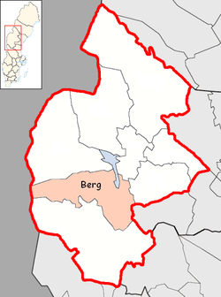
Berg Municipality
| Berg Municipality Bergs kommun | ||
|---|---|---|
| Municipality | ||
| ||
 | ||
| Country | Sweden | |
| County | Jämtland County | |
| Seat | Svenstavik | |
| Area[1] | ||
| • Total | 6,145.45 km2 (2,372.77 sq mi) | |
| • Land | 5,711.34 km2 (2,205.16 sq mi) | |
| • Water | 434.11 km2 (167.61 sq mi) | |
| Area as of 1 January 2014. | ||
| Population (31 December 2017)[2] | ||
| • Total | 7,122 | |
| • Density | 1.2/km2 (3.0/sq mi) | |
| Time zone | UTC+1 (CET) | |
| • Summer (DST) | UTC+2 (CEST) | |
| ISO 3166 code | SE | |
| Province | Jämtland and Härjedalen | |
| Municipal code | 2326 | |
| Website | www.berg.se | |

Berg Municipality (Swedish: Bergs kommun) is a municipality in Jämtland County in northern Sweden. Its seat is located in Svenstavik.
The present municipality was formed in 1971 when "old" Berg Municipality was amalgamated with four other entities.
As often in northern Sweden the municipality is one of the larger in terms of area, but one of the smaller in terms of population.
The nature reserve Hoverberget lies within Berg Municipality, near Svenstavik. The high mountain Helags and Sweden's highest public road, over Flatruet, are located in the western end of Berg Municipality. Berg means mountain in Swedish, and the name of the municipality (and the Berg Parish) comes from Hoverberget.
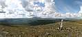 Panorama from Dunsjöfjället. In the center of the picture is Helagsfjället.
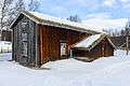 The oldest buildings in Ljungdalen (a small village in Berg). The house was probably built in the early 18th century, and is today part of a local heritage center.
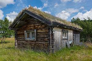 Building in Ljungris, owned by the Sámi community and used especially for Reindeer calf marking in the summer.
Localities
There are six localities (or urban areas) in Berg Municipality:[3]
| # | Locality | Population |
|---|---|---|
| 1 | Svenstavik | 948 |
| 2 | Hackås | 518 |
| 3 | Klövsjö | 312 |
| 4 | Åsarna | 271 |
| 5 | Myrviken | 224 |
| 6 | Rätan | 168 |
The municipal seat in bold
Notable people
- Georg Adlersparre (1760–1835), Swedish army commander, born in Hovermo now part of Berg Municipality.
- Thomas Wassberg, resident here (born elsewhere), Olympic Gold medalist.
Politics
Result of the 2010 election
Moderate Party 21,37%
Centre party 17,54%
Liberal People's Party 2,68%
Christian Democrats 2,57%
Swedish Social Democratic Party 39,44%
Left Party 5,29%
Green Party 5,31%
Sweden Democrats 4,65%
Other Parties 1,16%
See also
References
- ↑ "Statistiska centralbyrån, Kommunarealer den 1 januari 2014" (Microsoft Excel) (in Swedish). Statistics Sweden. Retrieved 2014-04-18.
- ↑ "Folkmängd i riket, län och kommuner 31 december 2017" (in Swedish). Statistics Sweden. February 21, 2018. Retrieved February 21, 2018.
- ↑ Statistics Sweden as of December 31, 2005
External links
| Wikimedia Commons has media related to Berg Municipality. |
Municipalities and seats of Jämtland County | ||
|---|---|---|
| Municipalities | ||
| Municipal seats | ||